FAA INFORMATION EFFECTIVE 17 APRIL 2025
Location
| FAA Identifier: | RDK |
| Lat/Long: | 41-00-39.0000N 095-15-31.9000W
41-00.650000N 095-15.531667W
41.0108333,-95.2588611
(estimated) |
| Elevation: | 1045 ft. / 318.5 m (surveyed) |
| Variation: | 04E (2000) |
| From city: | 2 miles W of RED OAK, IA |
| Time zone: | UTC -5 (UTC -6 during Standard Time) |
| Zip code: | 51566 |
Airport Operations
| Airport use: | Open to the public |
| Activation date: | 12/1941 |
| Control tower: | no |
| ARTCC: | MINNEAPOLIS CENTER |
| FSS: | FORT DODGE FLIGHT SERVICE STATION |
| NOTAMs facility: | RDK (NOTAM-D service available) |
| Attendance: | MON-FRI 0800-1700
ON CALL WKENDS AND HOLIDAYS 712-370-1511. |
| Wind indicator: | lighted |
| Segmented circle: | yes |
| Lights: | ACTVT MIRL RYS 17/35 & 05/23; PAPIS RYS 05/23 & 17/35 AND REIL RYS 05/23 & 17/35- CTAF. |
| Beacon: | white-green (lighted land airport)
Operates sunset to sunrise. |
Airport Communications
| CTAF/UNICOM: | 122.8 |
| WX AWOS-3P: | 123.925 (712-623-3220) |
| OMAHA APPROACH: | 124.5 |
| OMAHA DEPARTURE: | 124.5 |
| WX AWOS-3 at SDA (17 nm SW): | 125.525 (712-246-4021) |
- APCH/DEP SVC PRVDD BY OMAHA APCH CTL (R90) 0N 124.5/263.0.
Nearby radio navigation aids
| VOR radial/distance | | VOR name | | Freq | | Var |
|---|
| OVRr105/23.6 | | OMAHA VORTAC | | 116.30 | | 08E |
| NDB name | | Hdg/Dist | | Freq | | Var | | ID |
|---|
| PLATTSMOUTH | | 077/29.9 | | 329 | | 05E | | PMV | .--. -- ...- |
Airport Services
| Fuel available: | 100LL JET-A |
| Parking: | hangars and tiedowns |
| Airframe service: | MAJOR |
| Powerplant service: | MAJOR |
| Bottled oxygen: | NONE |
| Bulk oxygen: | NONE |
Runway Information
Runway 5/23
| Dimensions: | 5100 x 75 ft. / 1554 x 23 m |
| Surface: | concrete, in good condition |
| Weight bearing capacity: | | PCN 9 /R/C/W/T | | Single wheel: | 30.0 | | Double wheel: | 42.0 |
|
| Runway edge lights: | medium intensity |
| RUNWAY 5 | | RUNWAY 23 |
| Latitude: | 41-00.422223N | | 41-00.868563N |
| Longitude: | 095-16.003262W | | 095-15.064133W |
| Elevation: | 1042.1 ft. | | 1045.0 ft. |
| Traffic pattern: | left | | left |
| Runway heading: | 054 magnetic, 058 true | | 234 magnetic, 238 true |
| Displaced threshold: | 1000 ft. | | no |
| Markings: | nonprecision, in good condition | | nonprecision, in good condition |
| Visual slope indicator: | 2-light PAPI on left (3.00 degrees glide path) | | 2-light PAPI on left (3.00 degrees glide path) |
| Runway end identifier lights: | yes | | yes |
| Touchdown point: | yes, no lights | | yes, no lights |
| Obstructions: | 60 ft. rr, 1752 ft. from runway, 25:1 slope to clear | | 76 ft. trees, 1796 ft. from runway, 111 ft. left of centerline, 21:1 slope to clear |
Runway 17/35
| Dimensions: | 2901 x 60 ft. / 884 x 18 m |
| Surface: | concrete, in fair condition |
| Weight bearing capacity: | | PCN 8 /R/C/W/T | | Single wheel: | 12.5 |
|
| Runway edge lights: | medium intensity |
| RUNWAY 17 | | RUNWAY 35 |
| Latitude: | 41-00.857878N | | 41-00.382443N |
| Longitude: | 095-15.634430W | | 095-15.572983W |
| Elevation: | 1044.8 ft. | | 1038.7 ft. |
| Traffic pattern: | left | | left |
| Runway heading: | 170 magnetic, 174 true | | 350 magnetic, 354 true |
| Markings: | nonprecision, in good condition | | nonprecision, in good condition |
| Visual slope indicator: | 2-light PAPI on left (3.00 degrees glide path) | | 2-light PAPI on left (3.00 degrees glide path) |
| Runway end identifier lights: | yes | | yes |
| Touchdown point: | yes, no lights | | yes, no lights |
| Obstructions: | 23 ft. road, 680 ft. from runway, 20:1 slope to clear | | 44 ft. pline, 1124 ft. from runway, 83 ft. right of centerline, 21:1 slope to clear |
Runway 13/31
| Dimensions: | 2050 x 210 ft. / 625 x 64 m |
| Surface: | turf, in fair condition |
| Runway edge markings: | 13/31 ENDS & SIDES MARKED WITH YELLOW CONES. |
| Operational restrictions: | RUNWAY IS NOT MAINTAINED NOV-APR. |
| RUNWAY 13 | | RUNWAY 31 |
| Latitude: | 41-00.834843N | | 41-00.570452N |
| Longitude: | 095-15.561923W | | 095-15.284668W |
| Elevation: | 1042.4 ft. | | 1038.7 ft. |
| Traffic pattern: | left | | left |
| Runway heading: | 138 magnetic, 142 true | | 318 magnetic, 322 true |
| Touchdown point: | yes, no lights | | yes, no lights |
| Obstructions: | 27 ft. road, 900 ft. from runway, 33:1 slope to clear | | 51 ft. pole, 1210 ft. from runway, 23:1 slope to clear |
Airport Ownership and Management from official FAA records
| Ownership: | Publicly-owned |
| Owner: | CITY OF RED OAK
601 6TH ST
RED OAK, IA 51566
Phone 712-370-1511
NICK HILDRETH - CHMN - 402-658-1782 |
| Manager: | KEVIN MCGREW
1674 200TH ST
RED OAK, IA 51566
Phone 712-370-1511 |
Additional Remarks
| - | ULTRALIGHTS ON & INVOF ARPT. |
| - | +44' P/POLES AT 1650' RY 35. |
| - | RY 23 IS CALM WIND RY. |
| - | FOR CD CTC OMAHA APCH AT 402-682-4395. |
Instrument Procedures
NOTE: All procedures below are presented as PDF files. If you need a reader for these files, you should download the free Adobe Reader.NOT FOR NAVIGATION. Please procure official charts for flight.
FAA instrument procedures published for use from 17 April 2025 at 0901Z to 15 May 2025 at 0900z.
IAPs - Instrument Approach Procedures |
|---|
| RNAV (GPS) RWY 05 | |
download (231KB) |
| RNAV (GPS) RWY 17 | |
download (201KB) |
| VOR/DME-A | |
download (167KB) |
| NOTE: Special Alternate Minimums apply | |
download (61KB) |
| NOTE: Special Take-Off Minimums/Departure Procedures apply | |
download (158KB) |
Other nearby airports with instrument procedures:
KSDA - Shenandoah Municipal Airport (17 nm SW)
KICL - Schenck Field Airport (20 nm SE)
KCRZ - Corning Municipal Airport (23 nm E)
KAIO - Atlantic Municipal Airport (25 nm N)
KCBF - Council Bluffs Municipal Airport (27 nm NW)
|
|

Road maps at:
MapQuest
Bing
Google
| Aerial photo |
|---|
WARNING: Photo may not be current or correct

Do you have a better or more recent aerial photo of Red Oak Municipal Airport that you would like to share? If so, please send us your photo.
|
| Sectional chart |
|---|
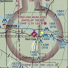
|
| Airport distance calculator |
|---|
|
|
| Sunrise and sunset |
|---|
|
Times for 17-Apr-2025
| | Local
(UTC-5) | | Zulu
(UTC) |
|---|
| Morning civil twilight | | 06:11 | | 11:11 |
| Sunrise | | 06:40 | | 11:40 |
| Sunset | | 20:02 | | 01:02 |
| Evening civil twilight | | 20:30 | | 01:30 |
|
| Current date and time |
|---|
| Zulu (UTC) | 17-Apr-2025 09:37:07 |
|---|
| Local (UTC-5) | 17-Apr-2025 04:37:07 |
|---|
|
| METAR |
|---|
| KRDK | 170915Z AUTO 17011KT 10SM SCT170 BKN190 OVC210 17/09 A2965 RMK AO2
|
KSDA
17nm SW | 170915Z AUTO 17014G20KT 10SM CLR 19/11 A2963 RMK AO2
|
|
| TAF |
|---|
KOFF
30nm W | 170200Z 1702/1808 15012G18KT 9999 SCT250 QNH2958INS BECMG 1713/1714 17015G25KT 9999 BKN025 BKN250 QNH2954INS BECMG 1717/1718 17015G25KT 9999 SCT030 BKN120 BKN250 QNH2936INS BECMG 1723/1724 VRB06KT 8000 -TSRA BKN040CB OVC100 QNH2931INS TEMPO 1800/1803 VRB30G50KT 4800 TSRAGR OVC020CB BECMG 1802/1803 36012G18KT 9000 -SHRA OVC020 QNH2935INS BECMG 1804/1805 36012G18KT 9999 NSW BKN015 QNH2940INS TX29/1722Z TN16/1712Z
|
KOMA
34nm NW | 170520Z 1706/1806 15013KT P6SM BKN250 WS017/20050KT FM171300 17015G25KT P6SM SCT025 BKN070 TEMPO 1714/1717 BKN025 FM180000 17012KT 6SM -TSRA SCT050CB OVC180 FM180200 35014KT P6SM SCT025 OVC150
|
|
| NOTAMs |
|---|
NOTAMs are issued by the DoD/FAA and will open in a separate window not controlled by AirNav.
|
|


