FAA INFORMATION EFFECTIVE 15 MAY 2025
Location
| FAA Identifier: | WWD |
| Lat/Long: | 39-00-30.1300N 074-54-30.6320W
39-00.502167N 074-54.510533W
39.0083694,-74.9085089
(estimated) |
| Elevation: | 21.7 ft. / 6.6 m (surveyed) |
| Variation: | 10W (1980) |
| From city: | 4 miles NW of WILDWOOD, NJ |
| Time zone: | UTC -4 (UTC -5 during Standard Time) |
| Zip code: | 08242 |
Airport Operations
| Airport use: | Open to the public |
| Activation date: | 05/1943 |
| Control tower: | no |
| ARTCC: | WASHINGTON CENTER |
| FSS: | MILLVILLE FLIGHT SERVICE STATION |
| NOTAMs facility: | WWD (NOTAM-D service available) |
| Attendance: | 0800-1700 |
| Wind indicator: | lighted |
| Segmented circle: | no |
| Lights: | ACTVT PAPI RWY 01, 10, 19, & 28; HIRL RWY 01/19; MIRL RWY 10/28 - CTAF. |
| Beacon: | white-green (lighted land airport)
Operates sunset to sunrise. |
Airport Communications
| CTAF/UNICOM: | 122.7 |
| WX AWOS-3PT: | 118.275 (609-886-9089) |
| ATLANTIC CITY APPROACH: | 124.6 |
| ATLANTIC CITY DEPARTURE: | 124.6 |
| CLEARANCE DELIVERY: | 121.7 |
| WX AWOS-3 at OBI (14 nm NE): | 120.475 (609-861-0610) |
Nearby radio navigation aids
| VOR radial/distance | | VOR name | | Freq | | Var |
|---|
| SIEr233/7.3 | | SEA ISLE VORTAC | | 114.80 | | 09W |
| ATRr059/18.5 | | WATERLOO VOR/DME | | 112.60 | | 09W |
| ACYr220/31.0 | | ATLANTIC CITY VORTAC | | 117.15 | | 10W |
| ENOr124/31.3 | | SMYRNA VORTAC | | 111.40 | | 09W |
| VCNr185/31.9 | | CEDAR LAKE VOR/DME | | 115.20 | | 10W |
| NDB name | | Hdg/Dist | | Freq | | Var | | ID |
|---|
| RAINBOW | | 168/26.7 | | 363 | | 11W | | RNB | .-. -. -... |
Airport Services
| Fuel available: | 100LL JET-A
100LL:SELF SERV AVBL H24 WITH CREDIT CARD LCTD ON APRON NEAR INTXN OF TWY A & F. |
| Parking: | hangars and tiedowns |
| Airframe service: | MINOR |
| Powerplant service: | MINOR |
| Bottled oxygen: | NONE |
| Bulk oxygen: | NONE |
Runway Information
Runway 1/19
| Dimensions: | 5252 x 150 ft. / 1601 x 46 m |
| Surface: | asphalt, in good condition |
| Weight bearing capacity: | | PCN 39 /F/C/X/T | | Single wheel: | 83.0 | | Double wheel: | 121.0 | | Double tandem: | 190.0 |
|
| Runway edge lights: | high intensity |
| RUNWAY 1 | | RUNWAY 19 |
| Latitude: | 39-00.136753N | | 39-01.001865N |
| Longitude: | 074-54.337648W | | 074-54.344972W |
| Elevation: | 21.7 ft. | | 15.2 ft. |
| Traffic pattern: | left | | left |
| Runway heading: | 010 magnetic, 360 true | | 190 magnetic, 180 true |
| Displaced threshold: | no | | 215 ft. |
| Declared distances: | TORA:5252 TODA:5252 ASDA:5036 LDA:5036 | | TORA:5252 TODA:5252 ASDA:5252 LDA:5036 |
| Markings: | nonprecision, in good condition | | nonprecision, in good condition |
| Visual slope indicator: | 4-light PAPI on left (3.00 degrees glide path) | | 4-light PAPI on left (3.00 degrees glide path) |
| Touchdown point: | yes, no lights | | yes, no lights |
| Instrument approach: | | | LOCALIZER |
| Obstructions: | 55 ft. tree, 1140 ft. from runway, 130 ft. left of centerline, 17:1 slope to clear | | 13 ft. road, 260 ft. from runway, 4:1 slope to clear
APCH RATIO 22:1 TO DSPLCD THR. |
Runway 10/28
| Dimensions: | 5000 x 150 ft. / 1524 x 46 m |
| Surface: | asphalt, in good condition |
| Weight bearing capacity: | | Single wheel: | 45.0 | | Double wheel: | 75.0 | | Double tandem: | 120.0 |
|
| Runway edge lights: | medium intensity |
| RUNWAY 10 | | RUNWAY 28 |
| Latitude: | 39-00.428852N | | 39-00.434403N |
| Longitude: | 074-55.216050W | | 074-54.160497W |
| Elevation: | 15.5 ft. | | 19.0 ft. |
| Traffic pattern: | left | | left |
| Runway heading: | 100 magnetic, 090 true | | 280 magnetic, 270 true |
| Markings: | nonprecision, in good condition | | nonprecision, in good condition |
| Visual slope indicator: | 4-light PAPI on left (3.00 degrees glide path) | | 4-light PAPI on left (3.00 degrees glide path) |
| Touchdown point: | yes, no lights | | yes, no lights |
| Obstructions: | 80 ft. trees, 2000 ft. from runway, 22:1 slope to clear | | 297 ft. tower, 9290 ft. from runway, 660 ft. right of centerline, 30:1 slope to clear |
Airport Ownership and Management from official FAA records
| Ownership: | Publicly-owned |
| Owner: | DELAWARE RIVER BAY AUTHORITY
PO BOX 71
NEW CASTLE, DE 19720
Phone 609-224-0303
DRBA IS LESSEE. PROPERTY OWNED BY CAPE MAY COUNTY, PO BOX 365, CAPE MAY COURT HOUSE, N.J. 08210. 609-886-0901. |
| Manager: | JOE MULHERON
201 FORRESTAL RD
RIO GRANDE, NJ 08242
Phone 302-757-2952 |
Additional Remarks
| A30A-19 | CALM WIND RWY. |
| - | BIRDS ON & INVOF ARPT. |
| - | PAEW WITHIN THE SAFETY AREAS OF ALL RYS AND TWYS DAILY MAY THRU OCT. |
| - | TWY A WEST OF TWY F CAN ONLY BE USED BY ACFT WITH WINGSPANS LESS THAN 79 FT. |
| - | UNMANNED AIRCRAFT SYSTEMS (UAS) ACTIVITY ON AND AROUND AIRFIELD. |
| - | ALL ULTRALIGHT ACFT, GLIDER OPS AND FORMATION FLTS PPR. CALL (609) 886-8652 MON-FRI 0800-1600. |
| - | FOR CD CTC ATLANTIC CITY APCH AT 609-485-6192. |
| - | TWY C IS AN FAA RESEARCH TWY AND IS RSTRD TO ACFT WITH WT LMT OF 28,000 LB AND SHOULD NOT BE USED BY ACFT GTR THAN 28,000 LB. |
| - | ARPT SFC CONDS NOT RPRTD 0800-1600. |
| - | TWY B SOUTH OF TWY A CAN ONLY BE USED BY ACFT WITH WINGSPANS LESS THAN 79 FT. |
Instrument Procedures
NOTE: All procedures below are presented as PDF files. If you need a reader for these files, you should download the free Adobe Reader.NOT FOR NAVIGATION. Please procure official charts for flight.
FAA instrument procedures published for use from 15 May 2025 at 0901Z to 13 June 2025 at 0900z.
IAPs - Instrument Approach Procedures |
|---|
| RNAV (GPS) RWY 01 | |
download (187KB) |
| RNAV (GPS) RWY 10 | |
download (232KB) |
| RNAV (GPS) RWY 19 | |
download (254KB) |
| RNAV (GPS) RWY 28 | |
download (219KB) |
| LOC RWY 19 | |
download (284KB) |
| VOR-A | |
download (196KB) |
| NOTE: Special Alternate Minimums apply | |
download (518KB) |
| NOTE: Special Take-Off Minimums/Departure Procedures apply | |
download (441KB) |
Other nearby airports with instrument procedures:
KOBI - Woodbine Municipal Airport (14 nm NE)
26N - Ocean City Municipal Airport (21 nm NE)
KMIV - Millville Municipal Airport (23 nm N)
KDOV - Dover Air Force Base (27 nm W)
KGED - Delaware Coastal Airport (29 nm SW)
|
|

Road maps at:
MapQuest
Bing
Google
| Aerial photo |
|---|
WARNING: Photo may not be current or correct
 Photo by David Newcomer
Photo taken 15-Jun-2018
looking northwest from 5,000'
Photo by David Newcomer
Photo taken 15-Jun-2018
looking northwest from 5,000'
Do you have a better or more recent aerial photo of Cape May County Airport that you would like to share? If so, please send us your photo.
|
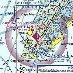
| Sectional chart |
|---|
|
CAUTION: Diagram may not be current

| Airport distance calculator |
|---|
|
|
| Sunrise and sunset |
|---|
|
Times for 20-May-2025
| | Local
(UTC-4) | | Zulu
(UTC) |
|---|
| Morning civil twilight | | 05:13 | | 09:13 |
| Sunrise | | 05:44 | | 09:44 |
| Sunset | | 20:09 | | 00:09 |
| Evening civil twilight | | 20:39 | | 00:39 |
|
| Current date and time |
|---|
| Zulu (UTC) | 20-May-2025 20:01:12 |
|---|
| Local (UTC-4) | 20-May-2025 16:01:12 |
|---|
|
| METAR |
|---|
| KWWD | 201956Z AUTO VRB06KT 10SM CLR 19/08 A2996 RMK AO2 SLP146 T01890083
|
|
| TAF |
|---|
KMIV
23nm N | 201727Z 2018/2118 34008KT P6SM FEW080 SCT250 FM202100 VRB04KT P6SM BKN150 FM210100 10003KT P6SM BKN070 FM210800 10004KT P6SM VCSH OVC050 FM211000 10006KT 6SM -RA BR OVC020 FM211300 11009KT 3SM -RA BR OVC008
|
KDOV
27nm W | 201600Z 2016/2122 33012G18KT 9999 SKC QNH2989INS BECMG 2022/2023 VRB03KT 9999 SCT030 BKN200 QNH2989INS BECMG 2105/2106 15009KT 9000 -SHRA FEW010 BKN030 OVC090 QNH2988INS BECMG 2111/2112 13012G18KT 6000 RA SCT007 BKN010 OVC030 QNH2983INS TEMPO 2113/2115 13012G20KT 1600 +RA VCTS BKN007CB OVC010 BECMG 2116/2117 11015G25KT 4800 SHRA SCT007 BKN010 OVC030 QNH2974INS TX21/2022Z TN13/2111Z
|
|
| NOTAMs |
|---|
NOTAMs are issued by the DoD/FAA and will open in a separate window not controlled by AirNav.
|
|


