FAA INFORMATION EFFECTIVE 20 FEBRUARY 2025
Location
| FAA Identifier: | Y93 |
| Lat/Long: | 44-59-48.8216N 084-07-38.0437W
44-59.813693N 084-07.634062W
44.9968949,-84.1272344
(estimated) |
| Elevation: | 880 ft. / 268 m (estimated) |
| Variation: | 06W (1985) |
| From city: | 1 mile SE of ATLANTA, MI |
| Time zone: | UTC -5 (UTC -4 during Daylight Saving Time) |
| Zip code: | 49709 |
Airport Operations
| Airport use: | Open to the public |
| Activation date: | 04/1940 |
| Control tower: | no |
| ARTCC: | MINNEAPOLIS CENTER |
| FSS: | LANSING FLIGHT SERVICE STATION |
| NOTAMs facility: | LAN (NOTAM-D service available) |
| Attendance: | ON CALL
FOR SVC CALL AMGR. |
| Wind indicator: | lighted |
| Segmented circle: | yes |
| Lights: | ACTVT PAPI RWY 23; LIRL RWY 05/23 & 13/31 - CTAF. |
Airport Communications
Nearby radio navigation aids
| VOR radial/distance | | VOR name | | Freq | | Var |
|---|
| APNr265/24.7 | | ALPENA VORTAC | | 116.50 | | 07W |
| CGGr060/(31.8) | | GRAYLING VOR | | 109.80 | | 06W |
| NDB name | | Hdg/Dist | | Freq | | Var | | ID |
|---|
| GRAYLING | | 070/33.3 | | 359 | | 06W | | GYG | --. -.-- --. |
Airport Services
Runway Information
Runway 5/23
| Dimensions: | 3000 x 60 ft. / 914 x 18 m |
| Surface: | asphalt, in fair condition |
| Runway edge lights: | low intensity |
| Runway edge markings: | FADED. |
| Operational restrictions: | CFM WINTER CONDS & SNOW REMOVAL PRIOR TO USE - CALL AMGR OR ASST AMGR. |
| RUNWAY 5 | | RUNWAY 23 |
| Latitude: | 44-59.624167N | | 44-59.963167N |
| Longitude: | 084-07.884000W | | 084-07.378167W |
| Elevation: | 880.0 ft. | | 872.0 ft. |
| Traffic pattern: | left | | left |
| Runway heading: | 053 magnetic, 047 true | | 233 magnetic, 227 true |
| Displaced threshold: | 1494 ft. | | 370 ft. |
| Markings: | basic, in poor condition | | basic, in poor condition |
| Visual slope indicator: | | | 2-light PAPI on left (4.00 degrees glide path) |
| Obstructions: | 54 ft. trees, 442 ft. from runway, 93 ft. left of centerline, 4:1 slope to clear
APCH RATIO 20:1 TO DTHR. | | 15 ft. road, 393 ft. from runway, 125 ft. left and right of centerline, 12:1 slope to clear
APCH RATIO 20:1 TO DTHR. |
Runway 13/31
| Dimensions: | 3223 x 100 ft. / 982 x 30 m |
| Surface: | turf, in fair condition |
| Runway edge lights: | low intensity
LIRL OPRS JUN-SEP. |
| Runway edge markings: | YELLOW CONES. |
| Operational restrictions: | CLSD NOV-APR & WHEN SNOW COVD. NO SNOW REMOVAL. |
| RUNWAY 13 | | RUNWAY 31 |
| Latitude: | 44-59.992000N | | 44-59.672667N |
| Longitude: | 084-07.935333W | | 084-07.338333W |
| Elevation: | 876.0 ft. | | 872.8 ft. |
| Traffic pattern: | left | | left |
| Runway heading: | 133 magnetic, 127 true | | 313 magnetic, 307 true |
| Displaced threshold: | 758 ft. | | 569 ft. |
| Obstructions: | 61 ft. trees, 10 ft. from runway, 124 ft. left of centerline, 1:1 slope to clear
APCH RATIO 20:1 TO DTHR. | | 55 ft. trees, 208 ft. from runway, 57 ft. right of centerline, 3:1 slope to clear
APCH RATIO 12:1 TO DTHR OVR +62 FT TREE, 789 FT DIST, 112 FT R. |
Airport Ownership and Management from official FAA records
| Ownership: | Publicly-owned |
| Owner: | BRILEY & AVERY TWPS
PO BOX 322
ATLANTA, MI 49709-0322
Phone 989-785-4050
BRILEY TWP OFC. |
| Manager: | DALE LA CLAIR
11746 COUNTY ROAD 487
ATLANTA, MI 49709-9204
Phone 989-306-6408
ASST AMGR 989-306-0926. |
Additional Remarks
| - | FOR CD CTC MINNEAPOLIS ARTCC AT 651-463-5588. |
| - | DEER & LRG BIRDS ON & INVOF ARPT. |
Instrument Procedures
There are no published instrument procedures at Y93.
Some nearby airports with instrument procedures:
KGLR - Gaylord Regional Airport (24 nm W)
KAPN - Alpena County Regional Airport (25 nm E)
KPZQ - Presque Isle County Airport (28 nm NE)
KGOV - Grayling Army Airfield (32 nm SW)
KBFA - Boyne Mountain Airport (35 nm W)
|
|

Road maps at:
MapQuest
Bing
Google
| Aerial photo |
|---|
WARNING: Photo may not be current or correct

Do you have a better or more recent aerial photo of Atlanta Municipal Airport that you would like to share? If so, please send us your photo.
|
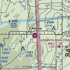
| Sectional chart |
|---|
|
| Airport distance calculator |
|---|
|
|
| Sunrise and sunset |
|---|
|
Times for 11-Mar-2025
| | Local
(UTC-5) | | Zulu
(UTC) |
|---|
| Morning civil twilight | | 06:28 | | 11:28 |
| Sunrise | | 06:57 | | 11:57 |
| Sunset | | 18:36 | | 23:36 |
| Evening civil twilight | | 19:05 | | 00:05 |
|
| Current date and time |
|---|
| Zulu (UTC) | 12-Mar-2025 03:01:34 |
|---|
| Local (UTC-5) | 11-Mar-2025 22:01:34 |
|---|
|
| METAR |
|---|
KAPN
24nm E | 120254Z AUTO 31004KT 10SM CLR M03/M09 A3003 RMK AO2 SLP178 T10331094 51019
|
KPZQ
28nm NE | 120255Z AUTO 00000KT 10SM CLR M04/M09 A3003 RMK AO2 T10401089
|
KGOV
32nm SW | 120255Z AUTO 00000KT 10SM CLR M04/M08 A2998 RMK AO2 SLP173 T10411082 52013 $
|
KBFA
35nm W | 120235Z AUTO 00000KT 10SM CLR M04/M09 A3002 RMK AO2
|
KMGN
42nm NW | 120255Z AUTO 00000KT 10SM CLR M03/M11 A3001 RMK AO2 T10321109
|
KSLH
42nm NW | 120255Z AUTO 00000KT 10SM CLR M04/M08 A3003 RMK AO2
|
KPLN
44nm NW | 120254Z AUTO 00000KT 10SM CLR M04/M09 A3002 RMK AO2 SLP178 T10391089 53007
|
KHTL
45nm SW | 120253Z AUTO 00000KT 10SM CLR M03/M09 A2999 RMK AO2 SLP170 T10331089 51015
|
KOSC
45nm SE | 120255Z AUTO 05003KT 10SM CLR M04/M07 A3001 RMK AO2
|
KY31
45nm S | 120255Z AUTO 00000KT 10SM CLR M04/M06 A3000 RMK AO2 T10421058
|
|
| TAF |
|---|
KAPN
24nm E | 111733Z 1118/1218 36014G25KT P6SM SCT035 FM112100 33009G21KT P6SM SCT030 BKN045 FM120000 VRB03KT P6SM SCT120 BKN200
|
|
| NOTAMs |
|---|
NOTAMs are issued by the DoD/FAA and will open in a separate window not controlled by AirNav.
|
|


