FAA INFORMATION EFFECTIVE 22 JANUARY 2026
Location
| FAA Identifier: | C91 |
| Lat/Long: | 41-59-34.5000N 086-07-41.8000W
41-59.575000N 086-07.696667W
41.9929167,-86.1282778
(estimated) |
| Elevation: | 747.3 ft. / 227.8 m (surveyed) |
| Variation: | 05W (2010) |
| From city: | 1 mile NW of DOWAGIAC, MI |
| Time zone: | UTC -5 (UTC -4 during Daylight Saving Time) |
| Zip code: | 49047 |
Airport Operations
| Airport use: | Open to the public |
| Activation date: | 07/1974 |
| Control tower: | no |
| ARTCC: | CHICAGO CENTER |
| FSS: | LANSING FLIGHT SERVICE STATION |
| NOTAMs facility: | LAN (NOTAM-D service available) |
| Attendance: | UNATNDD |
| Pattern altitude: | 1547.3 ft. MSL |
| Wind indicator: | lighted |
| Segmented circle: | yes |
| Lights: | ACTVT MIRL RWY 09/27; PAPI RWYS 09 & RWY 27; & REIL RWYS 09 & 27 - CTAF. |
| Beacon: | white-green (lighted land airport)
Operates sunset to sunrise. |
Airport Communications
| CTAF/UNICOM: | 122.8 |
| SOUTH BEND APPROACH: | 118.55 |
| SOUTH BEND DEPARTURE: | 118.55 |
| WX ASOS at BEH (16 nm NW): | 121.55 (269-925-9008) |
| WX AWOS-3 at EKM (17 nm S): | 124.475 (574-264-9002) |
| WX ASOS at SBN (19 nm SW): | 120.675 (574-200-0869) |
- APCH/DEP SVC PRVDD BY CHICAGO ARTCC ON 127.55/307.175 (GOSHEN RCAG) WHEN SOUTH BEND APCH CTL CLSD.
Nearby radio navigation aids
| VOR radial/distance | | VOR name | | Freq | | Var |
|---|
| GIJr032/15.9 | | GIPPER VORTAC | | 115.40 | | 00E |
| PMMr182/28.4 | | PULLMAN VOR/DME | | 112.10 | | 00E |
| NDB name | | Hdg/Dist | | Freq | | Var | | ID |
|---|
| STURGIS | | 293/32.8 | | 382 | | 04W | | IRS | .. .-. ... |
Airport Services
| Fuel available: | 100LL
100LL:SELF SVC FUEL AVBL 24 HR. |
| Parking: | tiedowns |
Runway Information
Runway 9/27
| Dimensions: | 4700 x 100 ft. / 1433 x 30 m |
| Surface: | asphalt, in good condition |
| Weight bearing capacity: | | Single wheel: | 30.0 | | Double wheel: | 60.0 |
|
| Runway edge lights: | medium intensity |
| RUNWAY 9 | | RUNWAY 27 |
| Latitude: | 41-59.621735N | | 41-59.620635N |
| Longitude: | 086-08.343092W | | 086-07.305887W |
| Elevation: | 735.8 ft. | | 746.7 ft. |
| Traffic pattern: | left | | right |
| Runway heading: | 095 magnetic, 090 true | | 275 magnetic, 270 true |
| Markings: | nonprecision, in good condition | | nonprecision, in good condition |
| Visual slope indicator: | 4-light PAPI on left (3.00 degrees glide path) | | 4-light PAPI on left (3.00 degrees glide path) |
| Runway end identifier lights: | yes | | yes |
| Touchdown point: | yes, no lights | | yes, no lights |
| Obstructions: | 54 ft. tree, 930 ft. from runway, 320 ft. right of centerline, 13:1 slope to clear
+2 FT CROPS, 2 FT TALL, 75 DIST, 250 L & R. | | 60 ft. trees, 947 ft. from runway, 266 ft. right of centerline, 12:1 slope to clear |
Runway 4/22
| Dimensions: | 2176 x 100 ft. / 663 x 30 m |
| Surface: | turf, in fair condition |
| Runway edge markings: | RWY 04/22 & RWY 22 DSPLCD THR MKD WITH 3 FT YELLOW CONES. |
| RUNWAY 4 | | RUNWAY 22 |
| Latitude: | 41-59.344667N | | 41-59.603667N |
| Longitude: | 086-07.584833W | | 086-07.253000W |
| Elevation: | 742.0 ft. | | 746.8 ft. |
| Traffic pattern: | left | | right |
| Runway heading: | 049 magnetic, 044 true | | 229 magnetic, 224 true |
| Displaced threshold: | no | | 388 ft. |
| Markings: | basic, in good condition | | basic, in good condition |
| Runway end identifier lights: | no | | no |
| Touchdown point: | yes, no lights | | yes, no lights |
| Obstructions: | 65 ft. tree, 1042 ft. from runway, 255 ft. left of centerline, 16:1 slope to clear | | 81 ft. tree, 921 ft. from runway, 231 ft. right of centerline, 11:1 slope to clear
APCH RATIO 20:1 AT DSLPD THR. |
Airport Ownership and Management from official FAA records
| Ownership: | Publicly-owned |
| Owner: | CITY OF DOWAGIAC
241 S. FRONT ST., 241 S FRONT ST
DOWAGIAC, MI 49047-1738
Phone 269-782-2195 |
| Manager: | OSCAR AZEVEDO
241 S. FRONT ST., 241 S FRONT ST
DOWAGIAC, MI 49047-1738
Phone 269-591-0054 |
Additional Remarks
| - | DEER & LRG BIRDS ON & INVOF ARPT. |
| - | MODEL R/C ACFT OPS E SIDE OF RWY 04/22. |
| - | ADMIN BLDG ACCESS, DEPRESS V, THEN III-II SIMULTANEOUS, THEN I. |
| - | FOR CD CTC SOUTH BEND APCH AT 574-251-2609. WHEN SOUTH BEND APCH CLSD, FOR CD CTC CHICAGO ARTCC AT 630-906-8921. |
Instrument Procedures
NOTE: All procedures below are presented as PDF files. If you need a reader for these files, you should download the free Adobe Reader.NOT FOR NAVIGATION. Please procure official charts for flight.
FAA instrument procedures published for use from 22 January 2026 at 0901Z to 19 February 2026 at 0900z.
IAPs - Instrument Approach Procedures |
|---|
| RNAV (GPS) RWY 09 | |
download (213KB) |
| RNAV (GPS) RWY 27 | |
download (208KB) |
| NOTE: Special Take-Off Minimums/Departure Procedures apply | |
download (411KB) |
Other nearby airports with instrument procedures:
3TR - Jerry Tyler Memorial Airport (10 nm SW)
C20 - Andrews University Airpark (11 nm W)
KBEH - Southwest Michigan Regional Airport (16 nm NW)
KEKM - Elkhart Municipal Airport (17 nm S)
KSBN - South Bend International Airport (19 nm SW)
|
|

Road maps at:
MapQuest
Bing
Google
| Aerial photo |
|---|
WARNING: Photo may not be current or correct
 Photo by Nate Enyedi
Photo taken 03-Nov-2007
Photo by Nate Enyedi
Photo taken 03-Nov-2007
Do you have a better or more recent aerial photo of Dowagiac Municipal Airport that you would like to share? If so, please send us your photo.
|
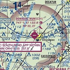
| Sectional chart |
|---|
|
| Airport distance calculator |
|---|
|
|
| Sunrise and sunset |
|---|
|
Times for 23-Jan-2026
| | Local
(UTC-5) | | Zulu
(UTC) |
|---|
| Morning civil twilight | | 07:36 | | 12:36 |
| Sunrise | | 08:06 | | 13:06 |
| Sunset | | 17:47 | | 22:47 |
| Evening civil twilight | | 18:17 | | 23:17 |
|
| Current date and time |
|---|
| Zulu (UTC) | 23-Jan-2026 20:53:32 |
|---|
| Local (UTC-5) | 23-Jan-2026 15:53:32 |
|---|
|
| METAR |
|---|
KBEH
15nm NW | 232034Z AUTO 31007G20KT 1/2SM SN BKN017 BKN029 OVC040 M16/M20 A3061 RMK AO2 P0000 T11611200
|
KEKM
18nm S | 232035Z AUTO 32007KT 5SM HZ BKN026 M16/M22 A3058 RMK AO2 SNE1953B2005E2031 P0000 T11591218 $
|
KSBN
19nm SW | 232017Z 31015KT 3/4SM R27L/4500VP6000FT -SN VV015 M17/M20 A3060 RMK AO2 P0000 T11671200
|
KLWA
22nm N | 232035Z AUTO 32012G18KT 1 1/2SM -SN HZ SCT015 BKN029 OVC038 M15/M22 A3060 RMK AO2 VIS 3/4V5
|
KHAI
24nm E | 232035Z AUTO 31011KT 5SM -SN HZ SCT022 BKN029 OVC034 M16/M21 A3056 RMK AO2
|
KAZO
30nm NE | 231953Z 29014G19KT 3SM -SN BKN038 M16/M23 A3054 RMK AO2 SLP365 P0000 T11611233
|
|
| TAF |
|---|
KSBN
19nm SW | 231902Z 2319/2418 31015G25KT 3SM -SHSN OVC030 TEMPO 2319/2321 1/4SM +SN OVC010 FM232100 31013G23KT 2SM -SHSN OVC015 FM232300 31008KT 2SM -SHSN OVC015 PROB30 2323/2405 1SM -SHSN OVC004 FM240500 VRB05KT P6SM OVC040
|
|
| NOTAMs |
|---|
NOTAMs are issued by the DoD/FAA and will open in a separate window not controlled by AirNav.
|
|

