FAA INFORMATION EFFECTIVE 23 JANUARY 2025
Location
| FAA Identifier: | AUN |
| Lat/Long: | 38-57-17.4000N 121-04-54.2000W
38-57.290000N 121-04.903333W
38.9548333,-121.0817222
(estimated) |
| Elevation: | 1538.4 ft. / 468.9 m (surveyed) |
| Variation: | 16E (1995) |
| From city: | 3 miles N of AUBURN, CA |
| Time zone: | UTC -8 (UTC -7 during Daylight Saving Time) |
| Zip code: | 95602 |
Airport Operations
| Airport use: | Open to the public |
| Activation date: | 05/1941 |
| Control tower: | no |
| ARTCC: | OAKLAND CENTER |
| FSS: | RANCHO MURIETA FLIGHT SERVICE STATION |
| NOTAMs facility: | AUN (NOTAM-D service available) |
| Attendance: | 0800-1800 |
| Pattern altitude: | HEL TFC PAT 580 FT AGL. |
| Wind indicator: | lighted |
| Segmented circle: | yes |
| Lights: | ACTVT PAPI RWY 07; MIRL RWY 07/25 - CTAF. PAPI RWY 25 OPER CONTINUOUS |
| Beacon: | white-green (lighted land airport)
Operates sunset to sunrise. |
| Landing fee: | yes, REFER TO ARPT WEBSITE FOR OVNGT PRKG FEES. |
Airport Communications
| CTAF/UNICOM: | 122.7 |
| WX AWOS-3: | 119.375 (530-888-8934) |
| NORCAL APPROACH: | 125.4 |
| NORCAL DEPARTURE: | 125.4 |
| WX AWOS-3 at LHM (13 nm W): | 124.25 (916-645-0698) |
| WX AWOS-3 at GOO (17 nm N): | 121.325 (530-273-0029) |
| WX AWOS-1 at O61 (17 nm S): | 120.0 (530-677-5392) |
Nearby radio navigation aids
| VOR radial/distance | | VOR name | | Freq | | Var |
|---|
| HNWr295/20.8 | | HANGTOWN VOR/DME | | 115.50 | | 17E |
| MCCr024/22.9 | | MC CLELLAN VOR/DME | | 109.20 | | 17E |
| MYVr095/24.5 | | MARYSVILLE VOR/DME | | 110.80 | | 16E |
| SACr019/37.7 | | SACRAMENTO VORTAC | | 115.20 | | 17E |
Airport Services
| Fuel available: | 100LL JET-A JET-A1 |
| Parking: | hangars and tiedowns |
| Airframe service: | MAJOR |
| Powerplant service: | MAJOR |
| Bottled oxygen: | HIGH/LOW |
| Bulk oxygen: | HIGH/LOW |
Runway Information
Runway 7/25
| Dimensions: | 3700 x 75 ft. / 1128 x 23 m |
| Surface: | asphalt, in good condition |
| Weight bearing capacity: | |
| Runway edge lights: | medium intensity |
| RUNWAY 7 | | RUNWAY 25 |
| Latitude: | 38-57.257837N | | 38-57.320527N |
| Longitude: | 121-05.291960W | | 121-04.515522W |
| Elevation: | 1493.0 ft. | | 1538.4 ft. |
| Traffic pattern: | left
HEL RIGHT TFC FOR RWY 07. | | left |
| Runway heading: | 068 magnetic, 084 true | | 248 magnetic, 264 true |
| Displaced threshold: | 200 ft. | | no |
| Markings: | nonprecision, in good condition | | nonprecision, in good condition |
| Visual slope indicator: | 2-light PAPI on left (3.00 degrees glide path) | | 2-light PAPI on left (3.50 degrees glide path)
PAPI UNUSBL BYD 5 DEG LEFT OF CNTRLN |
| Runway end identifier lights: | no | | no |
| Touchdown point: | yes, no lights | | yes, no lights |
| Obstructions: | 4 ft. hill, 342 ft. from runway, 35:1 slope to clear | | 10 ft. hill, 425 ft. from runway, 90 ft. left of centerline, 22:1 slope to clear |
Airport Ownership and Management from official FAA records
| Ownership: | Publicly-owned |
| Owner: | CITY OF AUBURN
1225 LINCOLN WAY
AUBURN, CA 95603
Phone 530-823-4211 |
| Manager: | TYGHE RICHARDSON
1225 LINCOLN WAY
AUBURN, CA 95603
Phone 530-888-8174 |
Additional Remarks
| - | FUEL 100LL & JET A AVAILABLE 24 HRS. |
| - | NOISE: VFR NOISE ABATEMENT PROCS: RWY 25 NO STRAIGHT OUT VFR DEP. AT END OF RWY TRACK 230 DEG OVER SELF-STORAGE FAC TO AVOID NOISE SENSITIVE AREAS. TURN ON CRS AFTER REACHING 2500 MSL. RWY 07 TURN ON CRS AFTER REACHING 2500 MSL. AVOID NOISE SENSITIVE AREAS. SEE NOISE ABATEMENT BROCHURE. |
| - | TSNT PRKG T'S ARE PAINTED BLUE. |
| - | ULTRALIGHT ACTIVITY ON AND INVOF ARPT. |
| - | FOR CD CTC NORCAL APCH AT 916-361-6874. |
| - | NOISE ABATEMENT ALL DEPS MIN PWR WHILE OBSG SAFE ACFT OPS. |
Instrument Procedures
NOTE: All procedures below are presented as PDF files. If you need a reader for these files, you should download the free Adobe Reader.NOT FOR NAVIGATION. Please procure official charts for flight.
FAA instrument procedures published for use from 23 January 2025 at 0901Z to 20 February 2025 at 0900z.
IAPs - Instrument Approach Procedures |
|---|
| RNAV (GPS) RWY 07 | |
download (220KB) |
| NOTE: Special Alternate Minimums apply | |
download (49KB) |
|
|---|
| YUBBA ONE (OBSTACLE) | |
download (441KB) |
| NOTE: Special Take-Off Minimums/Departure Procedures apply | |
download (354KB) |
Other nearby airports with instrument procedures:
KLHM - Lincoln Regional Airport/Karl Harder Field (13 nm W)
KGOO - Nevada County Airport (17 nm N)
KBAB - Beale Air Force Base (20 nm NW)
KPVF - Placerville Airport (21 nm SE)
KMCC - Mc Clellan Airfield (23 nm SW)
|
|

Road maps at:
MapQuest
Bing
Google
| Aerial photo |
|---|
WARNING: Photo may not be current or correct
 Photo taken 21-May-2012
looking north.
Photo taken 21-May-2012
looking north.
Do you have a better or more recent aerial photo of Auburn Municipal Airport that you would like to share? If so, please send us your photo.
|
| Sectional chart |
|---|
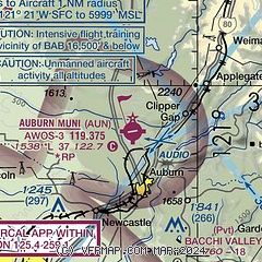
|
CAUTION: Diagram may not be current

| Airport distance calculator |
|---|
|
|
| Sunrise and sunset |
|---|
|
Times for 08-Feb-2025
| | Local
(UTC-8) | | Zulu
(UTC) |
|---|
| Morning civil twilight | | 06:37 | | 14:37 |
| Sunrise | | 07:05 | | 15:05 |
| Sunset | | 17:32 | | 01:32 |
| Evening civil twilight | | 18:00 | | 02:00 |
|
| Current date and time |
|---|
| Zulu (UTC) | 08-Feb-2025 19:32:25 |
|---|
| Local (UTC-8) | 08-Feb-2025 11:32:25 |
|---|
|
| METAR |
|---|
| KAUN | 081915Z AUTO 27006KT 10SM CLR 10/05 A3032 RMK A01
|
KLHM
13nm W | 081923Z AUTO 30005KT 10SM CLR 09/03 A3035 RMK AO1
|
KGOO
17nm N | 081915Z AUTO 00000KT 10SM CLR 07/M02 A3027 RMK A01
|
KBAB
20nm NW | 081855Z AUTO 34007KT 10SM CLR 09/03 A3035 RMK AO2 SLP281 T00900034 $
|
|
| TAF |
|---|
KBAB
20nm NW | 072355Z 0723/0901 18009KT 9999 SCT050 QNH3015INS BECMG 0805/0806 VRB06KT 9000 BR SKC QNH3025INS BECMG 0818/0819 33010KT 9999 NSW SKC QNH3030INS TX15/0800Z TN04/0811Z LAST NO AMDS AFT 0723 NEXT 0814
|
KMCC
23nm SW | 081731Z 0818/0918 33007KT P6SM SKC
|
|
| NOTAMs |
|---|
NOTAMs are issued by the DoD/FAA and will open in a separate window not controlled by AirNav.
|
|
FBO, Fuel Providers, and Aircraft Ground Support |
|---|
| | 
Business Name | |
Contact | |
Services / Description | |
Fuel Prices | |
Comments | |
|---|
|
|
|
530-823-0744
[web site]


|
|
Aviation fuel, Aircraft parking (ramp or tiedown), Pilots lounge / snooze room, Public telephone, Restrooms
|
|
 | | 100LL | Jet A | | FS | | $6.30 | | $6.55 | | SS | | $6.10 | | $6.35 | | GUARANTEED |
|
|

write
|
|

|
| |
Aviation Businesses, Services, and Facilities |
|---|
| |
Business Name | |
Contact | |
Services / Description | |
Distance | |
Comments | |
|---|
 |
|
530-878-5144
[web site]
[email] |
|
Local Avionic Installation and Certification Services
With a dedicated Fixed Base Operation (FBO) on the Auburn Municipal Airport, TGH provides the Auburn, CA region with a one-stop Avionics and Instrument Installation and Service Center.
TGH Commitment to Quality and Continuous Improvement
Excellence in quality is essential to the fulfillment of TGH Aviation's mission. In the conduct of this vital work, as in all its efforts, it is TGH Aviation's vision to achieve the performance of excellence characteristic of a global leader in the Aircraft Instrument Maintenance Services. We shall provide


|
|
on airport |
|
write
|
|
|
|
|
530-823-6204
toll-free 800-843-4976
[web site]
[email]
|
|
FAA Part 145 Instruments & Avionics Repair Station


|
|
on airport |
|
write
|
|
|
|
|
530-562-7913
[web site]
[email] |
|
Aircraft ground handling, Oxygen service, GPU / Power cart, Flight training, Aerial tours / aerial sightseeing, Aircraft maintenance, Avionics sales and service, ...
|
|
on airport |
|
2 read write
|
|
|
|
|
530-889-2000
[web site]
[email] |
|
Flight training, Aircraft rental, Aerial tours / aerial sightseeing, Aircraft charters, Aerial photography, Aircraft maintenance, Avionics sales and service, Aircraft modifications, ...
|
|
on airport |
|
1 read write
|
|
| |
Where to Eat: Catering, Restaurants, Food shops |
|---|
| |
Business Name | |
Contact | |
Services / Description | |
Distance | |
Comments | |
|---|
| Wings Grill & Flight Line |
|
530-885-0428
|
|
no information available
If you are affiliated with Wings Grill & Flight Line and would like to show here your services, contact info, web link, logo, and more, click here
|
|
on airport |
|
3 read write
|
|
| |
Would you like to see your business listed on this page? |
|---|
| | If your business provides an interesting product or service to pilots, flight crews, aircraft, or users of the Auburn Municipal Airport, you should consider listing it here. To start the listing process, click on the button below

|


