FAA INFORMATION EFFECTIVE 15 MAY 2025
Location
| FAA Identifier: | GRB |
| Lat/Long: | 44-29-04.6810N 088-07-46.9680W
44-29.078017N 088-07.782800W
44.4846336,-88.1297133
(estimated) |
| Elevation: | 695.1 ft. / 211.9 m (surveyed) |
| Variation: | 02W (1985) |
| From city: | 7 miles SW of GREEN BAY, WI |
| Time zone: | UTC -5 (UTC -6 during Standard Time) |
| Zip code: | 54313 |
Airport Operations
| Airport use: | Open to the public |
| Activation date: | 12/1948 |
| Control tower: | yes |
| ARTCC: | MINNEAPOLIS CENTER |
| FSS: | GREEN BAY FLIGHT SERVICE STATION |
| NOTAMs facility: | GRB (NOTAM-D service available) |
| Attendance: | 0500-2200 |
| Wind indicator: | lighted |
| Segmented circle: | no |
| Lights: | ACTVT MALSR RWY 06 & 36; REIL RWY 18; HIRL RWY 06/24 & 18/36 - CTAF. PAPI RWY 06, 18, 24 & 36 OPR CONS. WHEN ATCT CLSD PREFERRED RWY PRESET ON LOW OR MED INTST; INCR INTST - CTAF. |
| Beacon: | white-green (lighted land airport)
Operates sunset to sunrise. |
| Fire and rescue: | ARFF index C |
| International operations: | customs landing rights airport |
Airport Communications
| CTAF: | 118.7 |
| ATIS: | 124.1 |
| WX ASOS: | PHONE 920-204-7824 |
| GREEN BAY GROUND: | 121.9 [0530-2330] |
| GREEN BAY TOWER: | 118.7 257.8 [0530-2330] |
| GREEN BAY APPROACH: | 119.4 338.2 [0530-2330] |
| GREEN BAY DEPARTURE: | 126.55 [0530-2330] |
| CLEARANCE DELIVERY: | 121.75 |
| CLASS C: | 119.4 338.2 |
| EMERG: | 121.5 243.0 |
- APCH/DEP SVC PRVDD BY MINNEAPOLIS ARTCC ON 124.4/317.7 (MOSINEE RCAG) WHEN GREEN BAY APCH CLSD.
Nearby radio navigation aids
| VOR radial/distance | | VOR name | | Freq | | Var |
|---|
| GRBr146/5.1 | | GREEN BAY VORTAC | | 115.50 | | 01E |
| OSHr030/34.9 | | OSHKOSH VORTAC | | 116.75 | | 02E |
| NDB name | | Hdg/Dist | | Freq | | Var | | ID |
|---|
| DEPRE | | 003/5.2 | | 332 | | 02W | | SG | ... --. |
| FAMIS | | 063/5.4 | | 356 | | 02W | | GR | --. .-. |
Airport Services
| Fuel available: | 100LL JET-A |
| Parking: | hangars and tiedowns |
| Airframe service: | MAJOR |
| Powerplant service: | MAJOR |
| Bottled oxygen: | HIGH |
| Bulk oxygen: | HIGH |
Runway Information
Runway 18/36
| Dimensions: | 8700 x 150 ft. / 2652 x 46 m |
| Surface: | concrete/grooved, in good condition |
| Weight bearing capacity: | | Single wheel: | 120.0 | | Double wheel: | 170.0 | | Double tandem: | 290.0 |
|
| Runway edge lights: | high intensity |
| RUNWAY 18 | | RUNWAY 36 |
| Latitude: | 44-29.629033N | | 44-28.197278N |
| Longitude: | 088-08.019360W | | 088-08.016713W |
| Elevation: | 695.0 ft. | | 684.2 ft. |
| Traffic pattern: | right | | left |
| Runway heading: | 182 magnetic, 180 true | | 002 magnetic, 360 true |
| Displaced threshold: | 499 ft. | | no |
| Declared distances: | TORA:8700 TODA:8700 ASDA:8700 LDA:8201 | | TORA:8201 TODA:8201 ASDA:8201 LDA:8201 |
| Markings: | precision, in good condition | | precision, in good condition |
| Visual slope indicator: | 4-light PAPI on right (3.00 degrees glide path) | | 4-light PAPI on left (3.00 degrees glide path) |
| RVR equipment: | rollout | | touchdown |
| Approach lights: | | | MALSR: 1,400 foot medium intensity approach lighting system with runway alignment indicator lights |
| Runway end identifier lights: | yes | | no |
| Touchdown point: | yes, no lights | | yes, no lights |
| Instrument approach: | | | ILS |
| Obstructions: | 12 ft. road, 580 ft. from runway, 540 ft. left of centerline, 31:1 slope to clear
APCH RATIO 50:1 TO THE DSPLCD THLD. | | none |
Runway 6/24
| Dimensions: | 7700 x 150 ft. / 2347 x 46 m |
| Surface: | concrete/grooved, in good condition |
| Weight bearing capacity: | | Single wheel: | 120.0 | | Double wheel: | 170.0 | | Double tandem: | 290.0 |
|
| Runway edge lights: | high intensity |
| RUNWAY 6 | | RUNWAY 24 |
| Latitude: | 44-28.946668N | | 44-29.581772N |
| Longitude: | 088-08.282792W | | 088-06.751007W |
| Elevation: | 692.0 ft. | | 681.6 ft. |
| Traffic pattern: | left | | left |
| Runway heading: | 062 magnetic, 060 true | | 242 magnetic, 240 true |
| Declared distances: | TORA:7699 TODA:7699 ASDA:7699 LDA:7699 | | TORA:7699 TODA:7699 ASDA:7699 LDA:7699 |
| Markings: | precision, in good condition | | precision, in good condition |
| Visual slope indicator: | 4-light PAPI on left (3.00 degrees glide path) | | 4-light PAPI on left (3.00 degrees glide path) |
| RVR equipment: | touchdown | | rollout |
| Approach lights: | MALSR: 1,400 foot medium intensity approach lighting system with runway alignment indicator lights | | |
| Runway end identifier lights: | no | | no |
| Touchdown point: | yes, no lights | | yes, no lights |
| Instrument approach: | ILS/DME | | |
Airport Ownership and Management from official FAA records
| Ownership: | Publicly-owned |
| Owner: | BROWN COUNTY
2077 AIRPORT DRIVE, STE #18
GREEN BAY, WI 54313-5596
Phone 920-498-4800 |
| Manager: | MARTY PIETTE
2077 AIRPORT DRIVE
GREEN BAY, WI 54313-5596
Phone 920-498-4800 |
Additional Remarks
| A39-18/36 | PCR VALUE: 520/R/B/W/T |
| A39-06/24 | PCR VALUE: 520/R/B/W/T |
| - | BIRDS ON & INVOF ARPT. |
| - | TWY D BTN TWY H AND APCH END RWY 24 CLSD TO ACFT WINGSPAN MORE THAN 118 FT. |
| - | REQUEST VOLUNTARY COMPLIANCE IN AVOIDING NOISE SENSITIVE AREAS NORTH & EAST OF ARPT BETWEEN MIDNIGHT & 6 A.M. |
| - | TWY C NOT AVBL FOR ACR WITH MORE THAN 30 PAX SEATS. |
| - | TWY D WBND NO TURN ONTO TWY J. |
| - | TWY J SWB NO TURN ONTO NBND TWY M. |
| - | TWY M SBND NO TURN ONTO TWY J. |
| - | TWY J SWB NO TURN ONTO EB TWY D. |
| - | WHEN ATC CLSD FOR CD IF UNA TO CTC ON FSS FREQ, CTC MINNEAPOLIS ARTCC AT 651-463-5588. |
Instrument Procedures
NOTE: All procedures below are presented as PDF files. If you need a reader for these files, you should download the free Adobe Reader.NOT FOR NAVIGATION. Please procure official charts for flight.
FAA instrument procedures published for use from 15 May 2025 at 0901Z to 13 June 2025 at 0900z.
IAPs - Instrument Approach Procedures |
|---|
| ILS OR LOC RWY 06 | |
download (272KB) |
| ILS OR LOC RWY 36 | |
download (282KB) |
| RNAV (GPS) RWY 06 | |
download (261KB) |
| RNAV (GPS) RWY 18 | |
download (251KB) |
| RNAV (GPS) RWY 24 **CHANGED** | |
download (241KB) |
| RNAV (GPS) RWY 36 | |
download (255KB) |
| LOC BC RWY 24 | |
download (257KB) |
| Radar Approach Procedures available | |
download (151KB) |
| NOTE: Special Alternate Minimums apply | |
download (139KB) |
| NOTE: Special Take-Off Minimums/Departure Procedures apply | |
download (483KB) |
Other nearby airports with instrument procedures:
KATW - Appleton International Airport (22 nm SW)
KOCQ - Oconto/J Douglas Bake Municipal Airport (25 nm N)
KEZS - Shawano Municipal Airport (26 nm NW)
KCLI - Clintonville Municipal Airport (27 nm W)
KMTW - Manitowoc County Airport (29 nm SE)
|
|

Road maps at:
MapQuest
Bing
Google
| Aerial photo |
|---|
WARNING: Photo may not be current or correct
 Photo taken 02-Aug-2013
looking northeast.
Photo taken 02-Aug-2013
looking northeast.
Do you have a better or more recent aerial photo of Green Bay/Austin Straubel International Airport that you would like to share? If so, please send us your photo.
|
| Sectional chart |
|---|
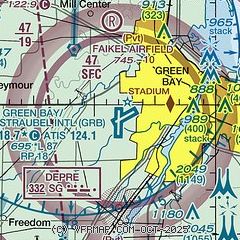
|
CAUTION: Diagram may not be current
 Download PDF
of official airport diagram from the FAA
| Airport distance calculator |
|---|
|
|
| Sunrise and sunset |
|---|
|
Times for 20-May-2025
| | Local
(UTC-5) | | Zulu
(UTC) |
|---|
| Morning civil twilight | | 04:46 | | 09:46 |
| Sunrise | | 05:21 | | 10:21 |
| Sunset | | 20:17 | | 01:17 |
| Evening civil twilight | | 20:52 | | 01:52 |
|
| Current date and time |
|---|
| Zulu (UTC) | 21-May-2025 01:32:50 |
|---|
| Local (UTC-5) | 20-May-2025 20:32:50 |
|---|
|
| METAR |
|---|
| KGRB | 210053Z 06011KT 10SM OVC018 08/07 A2986 RMK AO2 SLP117 T00780072
|
|
| TAF |
|---|
| KGRB | 202001Z 2020/2118 07012G20KT 3SM RA OVC035 FM210000 07009G20KT 3SM -RA OVC011 FM210200 07009G20KT 5SM -RA OVC008 FM210600 07010G20KT P6SM -RA OVC013 FM211300 06008G18KT P6SM -RA OVC007
|
|
| NOTAMs |
|---|
NOTAMs are issued by the DoD/FAA and will open in a separate window not controlled by AirNav.
|
|


