FAA INFORMATION EFFECTIVE 20 MARCH 2025
Location
| FAA Identifier: | LHV |
| Lat/Long: | 41-08-08.8000N 077-25-20.3000W
41-08.146667N 077-25.338333W
41.1357778,-77.4223056
(estimated) |
| Elevation: | 555.5 ft. / 169.3 m (surveyed) |
| Variation: | 11W (2005) |
| From city: | 2 miles E of LOCK HAVEN, PA |
| Time zone: | UTC -4 (UTC -5 during Standard Time) |
| Zip code: | 17745 |
Airport Operations
| Airport use: | Open to the public |
| Activation date: | 05/1938 |
| Control tower: | no |
| ARTCC: | NEW YORK CENTER |
| FSS: | WILLIAMSPORT FLIGHT SERVICE STATION |
| NOTAMs facility: | IPT (NOTAM-D service available) |
| Attendance: | MON - FRI 0800-1600, ALL SAT-SUN 1000-1400 |
| Wind indicator: | lighted |
| Segmented circle: | yes |
| Lights: | ACTVT PAPI RWY 09L & 27R; MIRL RWY 09L/27R - CTAF. |
| Beacon: | white-green (lighted land airport)
Operates sunset to sunrise. |
Airport Communications
- APCH/DEP SVC PRVDD BY NEW YORK ARTCC ON FREQS 134.8/338.3 (PHILIPSBURG RCAG).
Nearby radio navigation aids
| VOR radial/distance | | VOR name | | Freq | | Var |
|---|
| PSBr073/29.0 | | PHILIPSBURG VORTAC | | 115.50 | | 10W |
| FQMr256/31.6 | | WILLIAMSPORT VOR/DME | | 114.40 | | 09W |
| SEGr318/32.0 | | SELINSGROVE VOR/DME | | 110.40 | | 08W |
| ETGr108/32.9 | | KEATING VORTAC | | 116.00 | | 10W |
| SLTr141/33.5 | | SLATE RUN VORTAC | | 113.90 | | 08W |
| SFKr188/33.6 | | STONYFORK VOR/DME | | 108.60 | | 08W |
| MIPr290/34.9 | | MILTON VORTAC | | 109.20 | | 09W |
Airport Services
| Fuel available: | 100LL JET-A
100LL:FUEL AVBL AFT HOURS BY PRIOR REQ; CALL 570-295-7952 OR 570-726-3462. |
| Parking: | hangars and tiedowns |
| Airframe service: | MAJOR |
| Powerplant service: | MAJOR |
| Bottled oxygen: | NONE |
| Bulk oxygen: | NONE |
Runway Information
Runway 9L/27R
| Dimensions: | 3799 x 75 ft. / 1158 x 23 m |
| Surface: | asphalt, in good condition |
| Weight bearing capacity: | |
| Runway edge lights: | medium intensity |
| RUNWAY 9L | | RUNWAY 27R |
| Latitude: | 41-08.115912N | | 41-08.198920N |
| Longitude: | 077-25.752380W | | 077-24.932165W |
| Elevation: | 554.7 ft. | | 555.0 ft. |
| Traffic pattern: | left | | right |
| Runway heading: | 093 magnetic, 082 true | | 273 magnetic, 262 true |
| Displaced threshold: | no | | 465 ft. |
| Markings: | nonprecision, in good condition | | nonprecision, in good condition |
| Visual slope indicator: | 2-light PAPI on left (3.50 degrees glide path)
UNUSBL BYD 5 DEGS LEFT OF CNTRLN. | | 2-light PAPI on left (4.00 degrees glide path)
UNUSBL BYD 6 DEGS LEFT & 8 DEGS RIGHT OF CNTRLN. |
| Runway end identifier lights: | yes | | yes |
| Touchdown point: | yes, no lights | | yes, no lights |
| Obstructions: | 74 ft. trees, 1440 ft. from runway, 22 ft. right of centerline, 16:1 slope to clear | | 69 ft. trees, 611 ft. from runway, 96 ft. right of centerline, 5:1 slope to clear
14 FT BERM 84 FT OUT ON CNTRLN RWY 27R. |
Runway 9R/27L
| Dimensions: | 2179 x 100 ft. / 664 x 30 m |
| Surface: | turf, in good condition |
| Runway edge markings: | WHITE CONES MARK RWY EDGE AND THLD. |
| RUNWAY 9R | | RUNWAY 27L |
| Latitude: | 41-08.106165N | | 41-08.153382N |
| Longitude: | 077-25.568153W | | 077-25.097708W |
| Elevation: | 553.3 ft. | | 553.8 ft. |
| Traffic pattern: | left | | right |
| Runway heading: | 093 magnetic, 082 true | | 273 magnetic, 262 true |
| Markings: | NSTD, in good condition | | NSTD, in good condition |
| Touchdown point: | yes, no lights | | yes, no lights |
| Obstructions: | none | | 66 ft. trees, 1258 ft. from runway, 79 ft. left of centerline, 19:1 slope to clear |
Airport Ownership and Management from official FAA records
| Ownership: | Publicly-owned |
| Owner: | CITY OF LOCK HAVEN
20 EAST CHURCH STREET
LOCK HAVEN, PA 17745
Phone 570-893-5610 |
| Manager: | DOUGLAS WENKER
353 PROCTOR STREET
LOCK HAVEN, PA 17745
Phone 570-748-5123 |
Additional Remarks
| - | LOCAL WX ON CTAF (3 CLICKS). |
| - | BIRD ACTIVITY ON & INVOF ARPT. |
| - | NO SIMULTANEOUS RWY OPS. |
| - | FOR CD CTC NEW YORK ARTCC AT 631-468-1425. |
| - | RWY 09R/27L CLSD SS-SR DLY. |
Instrument Procedures
NOTE: All procedures below are presented as PDF files. If you need a reader for these files, you should download the free Adobe Reader.NOT FOR NAVIGATION. Please procure official charts for flight.
FAA instrument procedures published for use from 20 March 2025 at 0901Z to 17 April 2025 at 0900z.
IAPs - Instrument Approach Procedures |
|---|
| RNAV (GPS)-A | |
download (210KB) |
| NOTE: Special Take-Off Minimums/Departure Procedures apply | |
download (428KB) |
Other nearby airports with instrument procedures:
N96 - Bellefonte Airport (23 nm SW)
KIPT - Williamsport Regional Airport (23 nm E)
KUNV - State College Regional Airport (26 nm SW)
KRVL - Mifflin County Airport (29 nm S)
KSEG - Penn Valley Airport (32 nm SE)
|
|

Road maps at:
MapQuest
Bing
Google
| Aerial photo |
|---|
WARNING: Photo may not be current or correct
 Photo courtesy of AirNav, LLC
Photo taken 21-Jul-2010
Photo courtesy of AirNav, LLC
Photo taken 21-Jul-2010
Do you have a better or more recent aerial photo of William T Piper Memorial Airport that you would like to share? If so, please send us your photo.
|
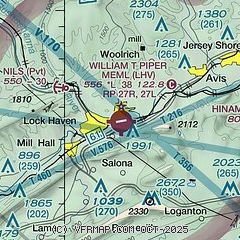
| Sectional chart |
|---|
|
| Airport distance calculator |
|---|
|
|
| Sunrise and sunset |
|---|
|
Times for 08-Apr-2025
| | Local
(UTC-4) | | Zulu
(UTC) |
|---|
| Morning civil twilight | | 06:14 | | 10:14 |
| Sunrise | | 06:43 | | 10:43 |
| Sunset | | 19:41 | | 23:41 |
| Evening civil twilight | | 20:09 | | 00:09 |
|
| Current date and time |
|---|
| Zulu (UTC) | 08-Apr-2025 18:06:27 |
|---|
| Local (UTC-4) | 08-Apr-2025 14:06:27 |
|---|
|
| METAR |
|---|
KIPT
24nm E | 081754Z 27019G30KT 10SM BKN065 BKN080 05/M10 A2982 RMK AO2 PK WND 31036/1727 SLP102 T00501100 10056 20000 53004
|
KUNV
25nm SW | 081753Z 28021G28KT 10SM BKN050 01/M10 A2988
|
KRVL
29nm S | 081515Z AUTO 29017G40KT 270V330 10SM SCT048 01/M09 A2986 RMK AO2
|
KSEG
32nm SE | 081753Z AUTO 10SM SCT065 A2985 RMK AO2 SLPNO 6//// 55000 $
|
KFIG
45nm W | 081754Z AUTO 28018G32KT 10SM BKN045 01/M10 A2989 RMK AO2 PK WND 27034/1717 SLP138 60000 T00111100 10017 21044 52008
|
|
| TAF |
|---|
KIPT
24nm E | 081126Z 0812/0912 28014G20KT P6SM SCT035 BKN040 FM082000 30021G29KT P6SM BKN100 FM090300 29009KT P6SM SKC
|
KUNV
25nm SW | 081143Z 0812/0912 30012G20KT 3/4SM -SHSN OVC015 FM081300 30021G30KT P6SM SCT025 BKN050 FM082000 30018G26KT P6SM SKC FM090300 29008KT P6SM SKC FM090900 26004KT P6SM SKC
|
|
| NOTAMs |
|---|
NOTAMs are issued by the DoD/FAA and will open in a separate window not controlled by AirNav.
|
|


