FAA INFORMATION EFFECTIVE 15 MAY 2025
Location
| FAA Identifier: | MKL |
| Lat/Long: | 35-35-59.5700N 088-54-56.2030W
35-35.992833N 088-54.936717W
35.5998806,-88.9156119
(estimated) |
| Elevation: | 433.3 ft. / 132.1 m (surveyed) |
| Variation: | 01W (2010) |
| From city: | 4 miles W of JACKSON, TN |
| Time zone: | UTC -5 (UTC -6 during Standard Time) |
| Zip code: | 38301 |
Airport Operations
| Airport use: | Open to the public |
| Activation date: | 07/1942 |
| Control tower: | yes |
| ARTCC: | MEMPHIS CENTER |
| FSS: | JACKSON FLIGHT SERVICE STATION |
| NOTAMs facility: | MKL (NOTAM-D service available) |
| Attendance: | MON-FRI 0600-2030, ALL SAT-SUN 0700-1930
AFT HR - 731-394-1755. |
| Wind indicator: | lighted |
| Segmented circle: | yes |
| Lights: | WHEN ATCT CLSD ACTVT MALSR RWY 02; HIRL RWY 02/20, MIRL RWY 11/29 - CTAF. |
| Beacon: | white-green (lighted land airport)
Operates sunset to sunrise. |
| Fire and rescue: | ARFF index A |
| Airline operations: | CLSD TO UNSKED ACR OPS MORE THAN 30 PAX SEATS EXC 24 HR PPR - AMGR. |
Airport Communications
| CTAF: | 127.15 |
| UNICOM: | 122.95 |
| WX ASOS: | 119.325 (731-424-0692) |
| JACKSON GROUND: | 120.9 [0700-1900] |
| JACKSON TOWER: | 127.15 249.95 [0700-1900] |
| NG OPS: | 138.75 373.9 41.5FM |
- APCH/DEP SVC PRVDD BY MEMPHIS ARTCC ON FREQS 134.65/316.15 (MCKELLAR RCAG).
Nearby radio navigation aids
| VOR radial/distance | | VOR name | | Freq | | Var |
|---|
| MKL at field | | MC KELLAR VOR/DME | | 114.85 | | 01W |
Airport Services
| Fuel available: | 100LL JET-A |
| Parking: | hangars and tiedowns |
| Airframe service: | MAJOR |
| Powerplant service: | MAJOR |
Runway Information
Runway 2/20
| Dimensions: | 6005 x 150 ft. / 1830 x 46 m |
| Surface: | asphalt/grooved, in excellent condition
GROOVED 55 FT EACH SIDE OF CNTRLN. |
| Weight bearing capacity: | | Single wheel: | 55.0 | | Double wheel: | 80.0 | | Double tandem: | 125.0 |
|
| Runway edge lights: | high intensity |
| RUNWAY 2 | | RUNWAY 20 |
| Latitude: | 35-35.427458N | | 35-36.343687N |
| Longitude: | 088-55.182840W | | 088-54.724260W |
| Elevation: | 433.3 ft. | | 411.2 ft. |
| Traffic pattern: | left | | left |
| Runway heading: | 023 magnetic, 022 true | | 203 magnetic, 202 true |
| Markings: | precision, in fair condition | | nonprecision, in fair condition |
| Visual slope indicator: | 4-light PAPI on left (3.00 degrees glide path)
PAPI UNUSBL BYD 8 DEG LEFT AND RIGHT OF CNTRLN. | | 4-light PAPI on left (3.00 degrees glide path) |
| Approach lights: | MALSR: 1,400 foot medium intensity approach lighting system with runway alignment indicator lights | | |
| Runway end identifier lights: | | | no |
| Touchdown point: | yes, no lights | | yes, no lights |
| Instrument approach: | ILS/DME | | |
| Obstructions: | none | | 40 ft. tree, 1400 ft. from runway, 600 ft. right of centerline, 30:1 slope to clear |
Runway 11/29
| Dimensions: | 3539 x 100 ft. / 1079 x 30 m |
| Surface: | asphalt, in fair condition
FADED. |
| Weight bearing capacity: | | PCN 13 /F/D/X/T | | Single wheel: | 27.0 |
|
| Runway edge lights: | medium intensity |
| RUNWAY 11 | | RUNWAY 29 |
| Latitude: | 35-36.285323N | | 35-36.064315N |
| Longitude: | 088-55.238640W | | 088-54.577600W |
| Elevation: | 407.6 ft. | | 415.7 ft. |
| Traffic pattern: | left | | left |
| Runway heading: | 113 magnetic, 112 true | | 293 magnetic, 292 true |
| Markings: | basic, in fair condition | | basic, in fair condition |
| Visual slope indicator: | 4-light PAPI on left (3.00 degrees glide path) | | 4-light PAPI on left (3.00 degrees glide path) |
| Touchdown point: | yes, no lights | | yes, no lights |
| Obstructions: | 66 ft. tree, 1650 ft. from runway, 50 ft. right of centerline, 21:1 slope to clear | | 45 ft. tree, 1100 ft. from runway, 320 ft. left of centerline, 20:1 slope to clear |
Airport Ownership and Management from official FAA records
| Ownership: | Publicly-owned |
| Owner: | JACKSON & MADISON CO ARPT AUTH
308 GRADY MONTGOMERY DR
JACKSON, TN 38301
Phone 731-423-0995 |
| Manager: | STEVE SMITH
308 GRADY MONTGOMERY DR
JACKSON, TN 38301
Phone 731-423-0995 |
Additional Remarks
| A39-02/20 | PCR VALUE: 1230/F/C/X/T |
| - | BASE OPS 0630-1600 MON-FRI; PPR C731-425-5600. |
| - | PPR FOR GND ACCESS TO FLD 2130-0600 - 731-394-1755. |
| - | ACR OPS MORE THAN 9 PAX SEATS NA IN EXCESS OF 15 MIN BFR OR AFT SKED ARR OR DEP TIMES WO PRIOR AVBLTY COORD WITH AMGR & CFM. |
| - | FOR CD CTC MEMPHIS ARTCC AT 901-368-8453/8449. |
Instrument Procedures
NOTE: All procedures below are presented as PDF files. If you need a reader for these files, you should download the free Adobe Reader.NOT FOR NAVIGATION. Please procure official charts for flight.
FAA instrument procedures published for use from 15 May 2025 at 0901Z to 13 June 2025 at 0900z.
IAPs - Instrument Approach Procedures |
|---|
| ILS OR LOC RWY 02 **CHANGED** | |
download (251KB) |
| RNAV (GPS) RWY 02 **CHANGED** | |
download (237KB) |
| RNAV (GPS) RWY 20 **CHANGED** | |
download (278KB) |
| VOR RWY 02 **CHANGED** | |
download (172KB) |
| NOTE: Special Alternate Minimums apply | |
download (163KB) |
| NOTE: Special Take-Off Minimums/Departure Procedures apply | |
download (393KB) |
Other nearby airports with instrument procedures:
M53 - Humboldt Municipal Airport (12 nm N)
KTGC - Gibson County Airport (20 nm N)
M08 - William L Whitehurst Field Airport (24 nm S)
KSZY - Robert Sibley Airport (31 nm SE)
M04 - Covington Municipal Airport (33 nm W)
|
|

Road maps at:
MapQuest
Bing
Google
| Aerial photo |
|---|
WARNING: Photo may not be current or correct
 Photo courtesy of AirNav, LLC
Photo taken 11-Sep-2012
looking northeast.
Photo courtesy of AirNav, LLC
Photo taken 11-Sep-2012
looking northeast.
Do you have a better or more recent aerial photo of Jackson Regional Airport that you would like to share? If so, please send us your photo.
|
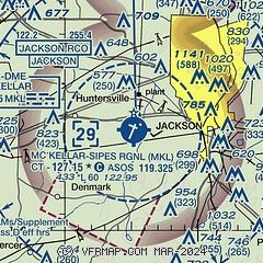
| Sectional chart |
|---|
|
 Download PDF
of official airport diagram from the FAA
| Airport distance calculator |
|---|
|
|
| Sunrise and sunset |
|---|
|
Times for 24-May-2025
| | Local
(UTC-5) | | Zulu
(UTC) |
|---|
| Morning civil twilight | | 05:17 | | 10:17 |
| Sunrise | | 05:46 | | 10:46 |
| Sunset | | 19:59 | | 00:59 |
| Evening civil twilight | | 20:28 | | 01:28 |
|
| Current date and time |
|---|
| Zulu (UTC) | 24-May-2025 17:54:36 |
|---|
| Local (UTC-5) | 24-May-2025 12:54:36 |
|---|
|
| METAR |
|---|
| KMKL | 241653Z 00000KT 10SM +RA BKN006 OVC009 17/17 A3018 RMK AO1 SLP217 P0005 T01720167 $
|
|
| TAF |
|---|
| KMKL | 241508Z 2415/2512 12006KT 4SM SHRA BR VCTS SCT005 OVC015CB FM242300 11005KT 3SM BR OVC015 FM250200 00000KT 4SM BR OVC009
|
|
| NOTAMs |
|---|
NOTAMs are issued by the DoD/FAA and will open in a separate window not controlled by AirNav.
|
|


