FAA INFORMATION EFFECTIVE 15 MAY 2025
Location
| FAA Identifier: | OPN |
| Lat/Long: | 32-57-18.0092N 084-15-50.7103W
32-57.300153N 084-15.845172W
32.9550026,-84.2640862
(estimated) |
| Elevation: | 797.7 ft. / 243.1 m (surveyed) |
| Variation: | 03W (1995) |
| From city: | 5 miles NE of THOMASTON, GA |
| Time zone: | UTC -4 (UTC -5 during Standard Time) |
| Zip code: | 30286 |
Airport Operations
| Airport use: | Open to the public |
| Activation date: | 07/1994 |
| Control tower: | no |
| ARTCC: | ATLANTA CENTER |
| FSS: | MACON FLIGHT SERVICE STATION |
| NOTAMs facility: | OPN (NOTAM-D service available) |
| Attendance: | 0800-1800
FOR AFT HRS SVC CALL 706-741-0562. |
| Wind indicator: | lighted |
| Segmented circle: | yes |
| Lights: | ACTVT MALSR RY 30 AND PAPI RYS 12 & 30 - CTAF. MIRL RY 12/30 PRESET MED INTST DUSK-0000; AFTER 0000 ACTVT - CTAF. |
| Beacon: | white-green (lighted land airport)
Operates sunset to sunrise. |
Airport Communications
| CTAF/UNICOM: | 122.8 |
| WX AWOS-3: | 133.975 (706-646-4123) |
| ATLANTA APPROACH: | 124.2 [0600-0000] |
| ATLANTA DEPARTURE: | 124.2 [0600-0000] |
| WX AWOS-3 at 6A2 (16 nm N): | 119.750 (770-227-3934) |
- ATLANTA LARGE TRACON PROVIDES APCH/DEP SVC 0615-2300 ON FREQ 124.2; ATLANTA ARTCC PROVIDES APCH/DEP SVC 2300-0615 ON FREQS 134.5/360.75 (MACON RCAG).
Nearby radio navigation aids
| NDB name | | Hdg/Dist | | Freq | | Var | | ID |
|---|
| YATES | | 302/4.4 | | 339 | | 03W | | OP | --- .--. |
| PECAT | | 157/23.6 | | 316 | | 05W | | FFC | ..-. ..-. -.-. |
| COWETA COUNTY | | 132/28.9 | | 234 | | 03W | | EQQ | . --.- --.- |
Airport Services
| Fuel available: | 100LL JET-A+ |
| Parking: | tiedowns |
| Airframe service: | MAJOR |
| Powerplant service: | MAJOR |
| Bottled oxygen: | NONE |
| Bulk oxygen: | NONE |
Runway Information
Runway 12/30
| Dimensions: | 6350 x 100 ft. / 1935 x 30 m |
| Surface: | asphalt, in good condition |
| Weight bearing capacity: | | Single wheel: | 20.0 | | Double wheel: | 50.0 |
|
| Runway edge lights: | medium intensity |
| RUNWAY 12 | | RUNWAY 30 |
| Latitude: | 32-57.543917N | | 32-57.056390N |
| Longitude: | 084-16.394717W | | 084-15.295627W |
| Elevation: | 786.8 ft. | | 797.5 ft. |
| Traffic pattern: | left | | left |
| Runway heading: | 121 magnetic, 118 true | | 301 magnetic, 298 true |
| Displaced threshold: | 648 ft. | | 699 ft. |
| Declared distances: | TORA:6350 TODA:6350 ASDA:6173 LDA:5525 | | TORA:6350 TODA:6350 ASDA:5662 LDA:4962 |
| Markings: | precision, in good condition | | precision, in good condition |
| Visual slope indicator: | 2-light PAPI on left (3.50 degrees glide path) | | 2-light PAPI on left (3.00 degrees glide path) |
| Approach lights: | | | MALSR: 1,400 foot medium intensity approach lighting system with runway alignment indicator lights |
| Touchdown point: | yes, no lights | | yes, no lights |
| Instrument approach: | | | ILS/DME |
| Obstructions: | 15 ft. road, 201 ft. from runway, 250 ft. left of centerline
6 FT FENCE AND ROAD 198 FT LEFT 200 FT FROM RY END. | | 19 ft. rr, 371 ft. from runway, 524 ft. right of centerline, 9:1 slope to clear
50:1 APCH TO DSPLCD THLD. |
Airport Ownership and Management from official FAA records
| Ownership: | Publicly-owned |
| Owner: | THOMASTON UPSON CO. ARPT AUTH
2347 DERAY RD
THOMASTON, GA 30286
Phone 706-647-4500 |
| Manager: | MITCH ELLERBEE
2347 DEL RAY ROAD
THOMASTON, GA 30286
Phone 706-647-4500 |
Additional Remarks
| - | FOR CD CTC ATLANTA APCH AT 678-364-6132, WHEN APCH CLSD CTC ATLANTA ARTCC AT 770-210-7692. |
Instrument Procedures
NOTE: All procedures below are presented as PDF files. If you need a reader for these files, you should download the free Adobe Reader.NOT FOR NAVIGATION. Please procure official charts for flight.
FAA instrument procedures published for use from 15 May 2025 at 0901Z to 13 June 2025 at 0900z.
IAPs - Instrument Approach Procedures |
|---|
| ILS OR LOC RWY 30 | |
download (268KB) |
| RNAV (GPS) RWY 12 | |
download (213KB) |
| RNAV (GPS) RWY 30 | |
download (224KB) |
| NDB RWY 30 | |
download (202KB) |
| NOTE: Special Alternate Minimums apply | |
download (155KB) |
| NOTE: Special Take-Off Minimums/Departure Procedures apply | |
download (480KB) |
Other nearby airports with instrument procedures:
6A2 - Griffin-Spalding County Airport (16 nm N)
6A1 - Butler Municipal Airport (23 nm S)
KHMP - Atlanta Speedway Airport (26 nm N)
KFFC - Atlanta Regional Airport-Falcon Field (29 nm NW)
KPIM - Harris County Airport (32 nm W)
|
|

Road maps at:
MapQuest
Bing
Google
| Aerial photo |
|---|
WARNING: Photo may not be current or correct
 Photos courtesy of AirNav, LLC
Photo taken 03-Feb-2013
looking southeast.
Photos courtesy of AirNav, LLC
Photo taken 03-Feb-2013
looking southeast.
Do you have a better or more recent aerial photo of Thomaston-Upson County Airport that you would like to share? If so, please send us your photo.
|
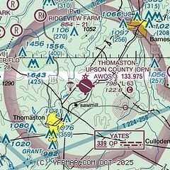
| Sectional chart |
|---|
|
| Airport distance calculator |
|---|
|
|
| Sunrise and sunset |
|---|
|
Times for 01-Jun-2025
| | Local
(UTC-4) | | Zulu
(UTC) |
|---|
| Morning civil twilight | | 06:02 | | 10:02 |
| Sunrise | | 06:30 | | 10:30 |
| Sunset | | 20:39 | | 00:39 |
| Evening civil twilight | | 21:08 | | 01:08 |
|
| Current date and time |
|---|
| Zulu (UTC) | 01-Jun-2025 07:34:48 |
|---|
| Local (UTC-4) | 01-Jun-2025 03:34:48 |
|---|
|
| METAR |
|---|
| KOPN | 010715Z AUTO 00000KT 10SM CLR 16/15 A2991 RMK AO2
|
K6A2
16nm N | 010715Z AUTO 27003KT 10SM CLR 17/15 A2990 RMK AO2
|
|
| TAF |
|---|
KMCN
35nm SE | 010527Z 0106/0206 27005KT P6SM FEW250 FM011500 29007KT P6SM SCT050 BKN150 FM020100 28004KT P6SM SCT200
|
KATL
42nm N | 010527Z 0106/0212 28005KT P6SM FEW250 FM011500 29008KT P6SM SCT050 BKN150 FM020100 28005KT P6SM FEW200
|
KCSG
43nm SW | 010527Z 0106/0206 29007KT P6SM FEW250 FM011500 29007KT P6SM SCT050 BKN150 FM020100 28004KT P6SM SCT200
|
|
| NOTAMs |
|---|
NOTAMs are issued by the DoD/FAA and will open in a separate window not controlled by AirNav.
|
|


