FAA INFORMATION EFFECTIVE 17 APRIL 2025
Location
| FAA Identifier: | SMO |
| Lat/Long: | 34-00-56.9590N 118-27-04.7020W
34-00.949317N 118-27.078367W
34.0158219,-118.4513061
(estimated) |
| Elevation: | 169.8 ft. / 51.8 m (surveyed) |
| Variation: | 12E (2020) |
| From city: | 3 miles E of SANTA MONICA, CA |
| Time zone: | UTC -7 (UTC -8 during Standard Time) |
| Zip code: | 90405 |
Airport Operations
| Airport use: | Open to the public |
| Activation date: | 04/1940 |
| Control tower: | yes |
| ARTCC: | LOS ANGELES CENTER |
| FSS: | HAWTHORNE FLIGHT SERVICE STATION |
| NOTAMs facility: | SMO (NOTAM-D service available) |
| Attendance: | CONTINUOUS |
| Pattern altitude: | TPA: 1200' AGL SINGLE-ENG; 1700' AGL TWIN-ENG. |
| Wind indicator: | lighted |
| Segmented circle: | yes |
| Lights: | WHEN ATCT CLSD ACTVT REIL RWY 21; MIRL RWY 03/21 - CTAF. |
| Beacon: | white-green (lighted land airport)
Operates sunset to sunrise. |
| Landing fee: | yes |
Airport Communications
| CTAF: | 120.1 |
| UNICOM: | 122.95 |
| ATIS: | 119.15 |
| WX ASOS: | PHONE 310-392-6453 |
| SANTA MONICA GROUND: | 121.9 [0700-2100] |
| SANTA MONICA TOWER: | 120.1 257.8 [0700-2100] |
| SOCAL APPROACH: | 124.3 ;101-245 SMO 124.9 ;069-100 LAX 125.2 ;246-341 LAX 135.05 ;342-068 SMO |
| SOCAL DEPARTURE: | 125.2 |
| BOGET STAR: | 135.05 |
| BONJO STAR: | 128.75 |
| CHOII DP: | 135.05 |
| CTRUS DP: | 125.2 |
| FERNANDO STAR: | 134.2 |
| IC: | 135.05 ;342-068 SMO |
| KIMMO STAR: | 119.85 |
| PEVEE DP: | 125.2 |
| SANTA MONICA DP: | 125.2 ;RWY 21 135.05 ;RWY 3 |
| THRNE STAR: | 126.7 |
| WAYVE STAR: | 119.85 |
| ZUUMA STAR: | 128.5 |
| WX ASOS at LAX (5 nm SE): | PHONE 310-602-6051 |
| WX ASOS at HHR (8 nm SE): | PHONE 310-973-8930 |
| WX ASOS at VNY (12 nm N): | PHONE 818-904-9213 |
| WX ASOS at BUR (12 nm NE): | PHONE 818-841-1384 |
| WX AWOS-3PT at CPM (13 nm SE): | 127.150 (310-631-3022) |
| WX AWOS-3PT at WHP (15 nm N): | 132.1 (818-899-9820) |
| WX ASOS at LGB (19 nm SE): | PHONE 562-247-0378 |
Nearby radio navigation aids
| VOR radial/distance | | VOR name | | Freq | | Var |
|---|
| SMO at field | | SANTA MONICA VOR/DME | | 110.80 | | 15E |
| LAXr334/5.1 | | LOS ANGELES VORTAC | | 113.60 | | 15E |
| VNYr156/12.6 | | VAN NUYS VOR/DME | | 113.10 | | 15E |
| SLIr290/24.2 | | SEAL BEACH VORTAC | | 115.70 | | 15E |
| FIMr119/29.6 | | FILLMORE VORTAC | | 112.50 | | 15E |
| VTUr086/30.3 | | VENTURA VOR/DME | | 116.55 | | 15E |
| POMr249/33.2 | | POMONA VORTAC | | 110.40 | | 15E |
| CMAr095/34.1 | | CAMARILLO VOR/DME | | 115.80 | | 15E |
| SXCr343/38.5 | | SANTA CATALINA VORTAC | | 114.15 | | 15E |
Airport Services
| Fuel available: | 100LL JET-A UL94
100LL:100LL FULL SVC ONLY.
UL94:UL94 AVBL AT SELF-SERVE ISLAND. |
| Parking: | tiedowns |
| Airframe service: | MAJOR |
| Powerplant service: | MAJOR |
| Bottled oxygen: | HIGH |
| Bulk oxygen: | HIGH |
Runway Information
Runway 3/21
| Dimensions: | 3500 x 150 ft. / 1067 x 46 m |
| Surface: | asphalt/grooved, in good condition |
| Weight bearing capacity: | | Single wheel: | 40.0 | | Double wheel: | 60.0 | | Double tandem: | 105.0 |
|
| Runway edge lights: | medium intensity |
| RUNWAY 3 | | RUNWAY 21 |
| Latitude: | 34-00.743782N | | 34-01.154843N |
| Longitude: | 118-27.321517W | | 118-26.835203W |
| Elevation: | 126.5 ft. | | 169.8 ft. |
| Traffic pattern: | right | | left |
| Runway heading: | 032 magnetic, 044 true | | 212 magnetic, 224 true |
| Declared distances: | TORA:3500 TODA:3500 ASDA:3500 LDA:3500 | | TORA:3500 TODA:3500 ASDA:3500 LDA:3500 |
| Markings: | nonprecision, in good condition | | nonprecision, in good condition |
| Visual slope indicator: | 4-light PAPI on left (3.42 degrees glide path) | | 4-light PAPI on left (3.50 degrees glide path) |
| Runway end identifier lights: | no | | yes |
| Touchdown point: | yes, no lights | | yes, no lights |
Helipad H1
| Dimensions: | 40 x 40 ft. / 12 x 12 m |
| Surface: | asphalt, in good condition |
| Runway edge lights: | PERI |
| Latitude: | 34-00.986500N | | |
| Longitude: | 118-26.947500W | | |
| Elevation: | 153.0 ft. | | |
| Traffic pattern: | left | | left |
| Markings: | basic, in good condition | | |
Airport Ownership and Management from official FAA records
| Ownership: | Publicly-owned |
| Owner: | CITY OF SANTA MONICA
3223 DONALD DOUGLAS LOOP S.
SANTA MONICA, CA 90405
Phone (310) 458-8692 |
| Manager: | STELIOS MAKRIDES
3223 DONALD DOUGLAS LOOP S.
SANTA MONICA, CA 90405
Phone (310) 458-8692
STELIOS.MAKRIDES@SANTAMONICA.GOV |
Additional Remarks
| - | PPR RQRD FOR DW ACFT IN EXCESS OF 60000 LBS CRTFYD MAX LDG WT, CTC AMGR 310-458-8692. |
| - | NO TOUCH/GO, STOP/GO, OR LOW APCH PERMITTED ON SAT, SUN, HOLS; WEEKDAYS SS-0700. |
| - | VFR DEPS RWY 21 TURN LEFT 10 DEGS OVER SMO VOR THEN TURN RIGHT 225 DEGS |
| - | IF DEP NORTH, NO RIGHT TURNS BFR RCHG SHORELINE. RWY 03 DEP NO TURNS PRIOR TO 405 FREEWAY LCTD 1 MI EAST. |
| - | ENG MAINT RUN-UP: JETS AND TURBOPROPS NORTH SIDE, WI 300 FT EAST OF TWY A4. PISTON SNGLS AND TWINS ON SOUTH SIDE, WI 300 FT EAST OF TWY B4. 0900-1700 ONLY. |
| - | CONS NOISE ORDINANCE IN EFCT CTC NOISE OFFICE FOR PROCS (310) 458-8692. |
| - | NOISE LMTS ALL ACFT: PURE JET AND STAGE II (WITH/WITHOUT HUSHKITS) PROHIBITED. MAX NOISE LIMIT 95.0 DBA SNGL EVENT NOISE EXPOSURE LEVEL (SENEL) RCRDD 2200 FT EXTDD CNTRLN. |
| - | PPR EX-MIL ACFT CTC ARPT MGR (310) 458-8692. |
| - | CURFEW: NO ENG STARTS, APU, OR TKOFS EXC PPR LIFEGUARD FLTS 2300-0700 MON-FRI AND 2300-0800 WKENDS. |
| - | TURBINE ACFT & ACFT OVER 12,000 LBS PROHIBITED ON SOUTH SIDE TSNT PKNG. |
| - | IFR JETS & TURBOPROPS CTC GND PRIOR TO ENG START. |
| - | PURE JET AND STAGE II (WITH/WITHOUT HUSH KITS) PROHIBITED. |
| - | TSNT PRKG SOUTH SIDE, NEXT TO BCN. |
| - | THE PAVED AREAS PRECDG THE RWY 3-21 THRS ARE NOT AVBL FOR LDG, TKOF, OR TAXI OPS. THE PAVED AREAS ARE NOW BLAST PADS CREATED FROM THE THRS' RELOCATION AND RWY LENGTH REDUCTION IN DECEMBER 2017. |
| - | ACFT MUST NOW EXIT THE RWY AT DSGND CONNECTOR TWYS. THE CONS RWY EXIT SYS IS NO LONGER AVBL. |
| - | FOR CD WHEN ATCT CLSD CTC SOCAL APCH AT 800-448-3724. |
| - | HEL FLT TRNG OPN PROHIBITED; HEL OPNS APCH ARPT BDRY AT MIDFIELD AT OR ABOVE 900 FT MSL. |
| - | INTXN DEPS AND FRMN LNDGS/DEPS PROHIBITED. |
| - | RWY 03/21 DEP END APPROX 1000 FT FM RESIDENTIAL HOMES. EXTENDED HIGH POWER SETTINGS ON RUN-UP OR DEP NEGATIVELY IMPACT THE COMMUNITY. |
Instrument Procedures
NOTE: All procedures below are presented as PDF files. If you need a reader for these files, you should download the free Adobe Reader.NOT FOR NAVIGATION. Please procure official charts for flight.
FAA instrument procedures published for use from 17 April 2025 at 0901Z to 15 May 2025 at 0900z.
STARs - Standard Terminal Arrivals |
|---|
| BOGET TWO (RNAV) | |
download (287KB) |
| BONJO THREE (RNAV) | |
2 pages:
[1] [2] (331KB) |
| FERNANDO SEVEN | |
2 pages:
[1] [2] (344KB) |
| KIMMO THREE | |
2 pages:
[1] [2] (318KB) |
| WAYVE ONE (RNAV) | |
download (190KB) |
| ZUUMA FOUR (RNAV) | |
download (244KB) |
| ZUUMA FOUR (RNAV) | |
download (244KB) |
IAPs - Instrument Approach Procedures |
|---|
| RNAV (GPS) RWY 21 | |
download (308KB) |
| RNAV (GPS) Y RWY 03 | |
download (307KB) |
| RNAV (GPS) Z RWY 03 | |
download (281KB) |
| VOR-A | |
download (333KB) |
| NOTE: Special Alternate Minimums apply | |
download (140KB) |
Departure Procedures |
|---|
| CHOII THREE (RNAV) | |
2 pages:
[1] [2] (362KB) |
| CTRUS FOUR (RNAV) | |
2 pages:
[1] [2] (441KB) |
| PEVEE SIX (RNAV) | |
2 pages:
[1] [2] (302KB) |
| SANTA MONICA THREE (RNAV) | |
download (269KB) |
|
|---|
| TOPANGA THREE (OBSTACLE) | |
download (292KB) |
| NOTE: Special Take-Off Minimums/Departure Procedures apply | |
download (355KB) |
Other nearby airports with instrument procedures:
KLAX - Los Angeles International Airport (5 nm SE)
KHHR - Jack Northrop Field/Hawthorne Municipal Airport (8 nm SE)
KVNY - Van Nuys Airport (12 nm N)
KBUR - Bob Hope Airport (12 nm NE)
KTOA - Zamperini Field Airport (14 nm SE)
KWHP - Whiteman Airport (15 nm N)
KLGB - Long Beach Airport (Daugherty Field) (19 nm SE)
|
|

Road maps at:
MapQuest
Bing
Google
| Aerial photo |
|---|
WARNING: Photo may not be current or correct
 Photo courtesy of focalflight.com
Photo taken 15-May-2020
Photo courtesy of focalflight.com
Photo taken 15-May-2020
Do you have a better or more recent aerial photo of Santa Monica Municipal Airport that you would like to share? If so, please send us your photo.
|
| Sectional chart |
|---|
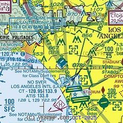
|
 Download PDF
of official airport diagram from the FAA
| Airport distance calculator |
|---|
|
|
| Sunrise and sunset |
|---|
|
Times for 12-May-2025
| | Local
(UTC-7) | | Zulu
(UTC) |
|---|
| Morning civil twilight | | 05:28 | | 12:28 |
| Sunrise | | 05:55 | | 12:55 |
| Sunset | | 19:45 | | 02:45 |
| Evening civil twilight | | 20:12 | | 03:12 |
|
| Current date and time |
|---|
| Zulu (UTC) | 13-May-2025 04:26:40 |
|---|
| Local (UTC-7) | 12-May-2025 21:26:40 |
|---|
|
| METAR |
|---|
| KSMO | 130351Z 23013G20KT 10SM CLR 16/11 A2991 RMK AO2 SLP126 T01610111
|
KLAX
6nm SE | 130353Z 25012KT 10SM FEW020 FEW250 16/12 A2992 RMK AO2 SLP131 T01560122 $
|
KHHR
8nm SE | 130353Z AUTO 26010KT 10SM CLR 17/12 A2992 RMK AO2 SLP132 T01670122 $
|
KBUR
12nm N | 130353Z 13007KT 10SM FEW046 17/11 A2991 RMK AO2 SLP119 T01670106
|
KVNY
12nm N | 130351Z VRB04KT 10SM SCT044 16/09 A2990 RMK AO2 SLP119 T01610089 $
|
KWHP
14nm N | 130155Z 10010G25KT 10SM FEW041 19/08 A2989
|
KTOA
15nm SE | 130250Z 25010KT 10SM FEW020 SCT060 17/12 A2992 RMK LAST
|
KLGB
19nm SE | 130353Z 23005KT 10SM CLR 17/11 A2992 RMK AO2 SLP132 T01720111
|
|
| TAF |
|---|
| KSMO | 130005Z 1300/1324 24010G18KT P6SM BKN200 FM130400 25012G20KT P6SM SCT200 FM130700 26008KT P6SM BKN250 FM131000 VRB03KT P6SM BKN015 FM131300 10006KT P6SM BKN025 FM131600 12006KT P6SM SCT030 FM132000 23012G18KT P6SM SKC
|
KLAX
6nm SE | 122059Z 1221/1324 25012KT P6SM SCT030 BKN200 FM122200 26018G25KT P6SM BKN200 FM130500 27010KT P6SM SCT200 FM131000 VRB03KT P6SM BKN015 FM131300 10010KT P6SM BKN025 FM131600 12008KT P6SM SCT030 FM131800 24006KT P6SM SCT035 FM132100 26015G22KT P6SM SKC
|
KBUR
12nm N | 130150Z 1302/1324 16008KT P6SM SCT200 FM130500 15004KT P6SM SKC FM131000 14006KT P6SM -DZ BKN050 FM131600 VRB03KT P6SM SCT250 FM132000 19009G16KT P6SM SCT250
|
KVNY
12nm N | 130156Z 1302/1324 14010KT P6SM SCT200 FM130400 VRB03KT P6SM SKC FM131000 VRB03KT P6SM -DZ BKN015 FM131600 15005KT P6SM BKN025 FM132000 17010G18KT P6SM SCT250
|
KLGB
19nm SE | 130115Z 1300/1324 29012G20KT P6SM SCT200 FM130500 VRB03KT P6SM SCT200 FM131000 VRB03KT P6SM BKN015 FM131400 18006KT P6SM BKN030 FM131600 18010KT P6SM BKN025 FM131900 19015G20KT P6SM BKN050
|
|
| NOTAMs |
|---|
NOTAMs are issued by the DoD/FAA and will open in a separate window not controlled by AirNav.
|
|


