FAA INFORMATION EFFECTIVE 27 NOVEMBER 2025
Location
| FAA Identifier: | T41 |
| Lat/Long: | 29-40-09.3000N 095-03-51.1000W
29-40.155000N 095-03.851667W
29.6692500,-95.0641944
(estimated) |
| Elevation: | 25.1 ft. / 7.7 m (surveyed) |
| Variation: | 05E (1990) |
| From city: | 3 miles NW of LA PORTE, TX |
| Time zone: | UTC -6 (UTC -5 during Daylight Saving Time) |
| Zip code: | 77571 |
Airport Operations
| Airport use: | Open to the public |
| Activation date: | 10/1943 |
| Control tower: | no |
| ARTCC: | HOUSTON CENTER |
| FSS: | MONTGOMERY COUNTY FLIGHT SERVICE STATION |
| NOTAMs facility: | CXO (NOTAM-D service available) |
| Attendance: | DAYLIGHT HOURS |
| Wind indicator: | lighted |
| Segmented circle: | yes |
| Lights: | ACTVT REIL RWY 12; PAPI RWY 12; MIRL RWYS 05/23 & 12/30 - CTAF. |
| Beacon: | white-green (lighted land airport)
Operates sunset to sunrise. |
Airport Communications
| CTAF/UNICOM: | 122.7 |
| WX AWOS-3PT: | 120.275 (281-471-2206) |
| HOUSTON APPROACH: | 134.45 [1345-0600Z++ MON-THU; 1345-2345Z++ FRI; CLSD SAT, SUN AND HOL EXC BY NOTAM, HRS SUBJ TO CHG.] |
| HOUSTON DEPARTURE: | 134.45 [1345-0600Z++ MON-THU; 1345-2345Z++ FRI; CLSD SAT, SUN AND HOL EXC BY NOTAM, HRS SUBJ TO CHG.] |
| CLEARANCE DELIVERY: | 125.6 |
| ALEXANDRIA DP: | 134.45 |
| BLTWY RNAV DP: | 134.45 |
| BLUBELL STAR: | 124.225 |
| BORRN RNAV DP: | 134.45 |
| CESAN STAR: | 121.3 |
| CRIED DP: | 134.45 |
| DREMR DP: | 134.45 |
| EL DORADO DP: | 134.45 |
| GIFFA DP: | 134.45 |
| HOODO RNAV DP: | 134.45 |
| HUDZY STAR: | 120.05 |
| INDIE RNAV DP: | 134.45 |
| KARRR RNAV DP: | 134.45 |
| LEONA DP: | 134.45 |
| LUFKIN DP: | 134.45 |
| LURIC DP: | 134.45 |
| MMALT RNAV DP: | 134.45 |
| OHIIO STAR: | 120.05 |
| SNDAY RNAV STAR: | 124.225 |
| STRYA DP: | 134.45 |
| STYCK DP: | 134.45 |
| TKNIQ STAR: | 119.625 |
| TSHIRT STAR: | 119.175 |
| TSHRT STAR: | 119.175 |
| WAPPL STAR: | 120.05 |
| WATFO DP: | 134.45 |
| WYLSN RNAV DP: | 134.45 |
| WX AWOS-3 at EFD (6 nm SW): | 135.575 (713-847-4430) |
| WX ASOS at HOU (11 nm W): | PHONE 713-847-1462 |
| WX ASOS at LVJ (13 nm SW): | 118.525 (281-992-1853) |
Nearby radio navigation aids
| VOR radial/distance | | VOR name | | Freq | | Var |
|---|
| MHFr287/18.1 | | TRINITY VOR/DME | | 114.75 | | 07E |
| IAHr135/22.6 | | HUMBLE VORTAC | | 116.60 | | 05E |
| VUHr331/26.1 | | SCHOLES VOR/DME | | 113.00 | | 06E |
| DASr210/38.1 | | DAISETTA VORTAC | | 116.90 | | 05E |
Airport Services
| Fuel available: | 100LL JET-A
100LL:FUEL AVBL SELF SERVE 24 HRS. |
| Parking: | tiedowns |
| Airframe service: | MAJOR |
| Powerplant service: | MAJOR |
Runway Information
Runway 12/30
| Dimensions: | 4165 x 75 ft. / 1269 x 23 m |
| Surface: | asphalt, in fair condition |
| Weight bearing capacity: | |
| Runway edge lights: | medium intensity |
| RUNWAY 12 | | RUNWAY 30 |
| Latitude: | 29-40.352960N | | 29-39.947423N |
| Longitude: | 095-04.175895W | | 095-03.540780W |
| Elevation: | 24.3 ft. | | 24.2 ft. |
| Traffic pattern: | left | | left |
| Runway heading: | 121 magnetic, 126 true | | 301 magnetic, 306 true |
| Displaced threshold: | 190 ft. | | 402 ft. |
| Markings: | nonprecision, in good condition | | nonprecision, in good condition |
| Visual slope indicator: | 4-light PAPI on left (3.00 degrees glide path)
PAPI RWY 12 UNUSBL BYD 8 DEG L OF RWY CNTRLN. | | |
| Runway end identifier lights: | yes | | |
| Touchdown point: | yes, no lights | | yes, no lights |
| Obstructions: | 43 ft. trees, 1090 ft. from runway, 126 ft. right of centerline, 20:1 slope to clear
APCH RATIO 26:1 TO DSPLCD THR OVR 48 FT TREES 1275 FT 125 FT L. | | 6 ft. fence, 201 ft. from runway, 236 ft. left of centerline
6 FT FENCE 199 FT FM THLD 246 FT LEFT OF CNTRLN. |
Runway 5/23
| Dimensions: | 2998 x 75 ft. / 914 x 23 m |
| Surface: | asphalt, in fair condition |
| Weight bearing capacity: | |
| Runway edge lights: | medium intensity |
| RUNWAY 5 | | RUNWAY 23 |
| Latitude: | 29-40.006002N | | 29-40.314995N |
| Longitude: | 095-04.065010W | | 095-03.622738W |
| Elevation: | 23.2 ft. | | 23.7 ft. |
| Traffic pattern: | left | | left |
| Runway heading: | 046 magnetic, 051 true | | 226 magnetic, 231 true |
| Markings: | basic, in good condition | | basic, in good condition |
| Touchdown point: | yes, no lights | | yes, no lights |
| Obstructions: | 43 ft. pole, marked and lighted, 1060 ft. from runway, 68 ft. right of centerline, 20:1 slope to clear | | 39 ft. trees, 760 ft. from runway, 190 ft. right of centerline, 14:1 slope to clear |
Airport Ownership and Management from official FAA records
| Ownership: | Publicly-owned |
| Owner: | CITY OF LA PORTE
604 W FAIRMONT PKWY
LA PORTE, TX 77571
Phone 281-471-9650 |
| Manager: | RAY MAYO
2963 N 23RD STREET
LA PORTE, TX 77571
Phone 281-471-9650
DIRECTOR OF PUBLIC WORKS. |
Additional Remarks
| - | FOR CD CTC HOUSTON APCH AT 281-443-5844. TO CNL IFR CTC HOUSTON APCH AT 281-443-5888. |
Instrument Procedures
NOTE: All procedures below are presented as PDF files. If you need a reader for these files, you should download the free Adobe Reader.NOT FOR NAVIGATION. Please procure official charts for flight.
FAA instrument procedures published for use from 27 November 2025 at 0901Z to 25 December 2025 at 0900Z.
STARs - Standard Terminal Arrivals |
|---|
| CESAN FOUR (RNAV) | |
2 pages:
[1] [2] (403KB) |
| HUDZY FIVE | |
2 pages:
[1] [2] (280KB) |
| OHIIO FOUR | |
download (265KB) |
| SNDAY ONE (RNAV) | |
download (232KB) |
| TKNIQ THREE (RNAV) | |
2 pages:
[1] [2] (328KB) |
| TSHRT TWO | |
2 pages:
[1] [2] (338KB) |
| WAPPL SEVEN (RNAV) | |
2 pages:
[1] [2] (404KB) |
| WAPPL SEVEN (RNAV), CONT.2 | |
download (282KB) |
IAPs - Instrument Approach Procedures |
|---|
| RNAV (GPS) RWY 30 | |
download (227KB) |
Departure Procedures |
|---|
| ALEXANDRIA THREE **CHANGED** | |
2 pages:
[1] [2] (395KB) |
| BLTWY SEVEN (RNAV) | |
download (172KB) |
| BORRN SIX (RNAV) | |
2 pages:
[1] [2] (315KB) |
| CRIED ONE | |
2 pages:
[1] [2] (299KB) |
| EL DORADO ONE | |
2 pages:
[1] [2] (312KB) |
| GIFFA ONE | |
2 pages:
[1] [2] (295KB) |
| HOODO SEVEN (RNAV) | |
download (216KB) |
| INDIE EIGHT (RNAV) | |
download (198KB) |
| KARRR SEVEN (RNAV) | |
2 pages:
[1] [2] (261KB) |
| LEONA FOUR | |
2 pages:
[1] [2] (409KB) |
| LUFKIN FOUR **NEW** | |
2 pages:
[1] [2] (329KB) |
| LURIC EIGHT (RNAV) | |
download (220KB) |
| MMALT SEVEN (RNAV) | |
download (225KB) |
| STRYA EIGHT (RNAV) | |
download (208KB) |
| STYCK EIGHT (RNAV) | |
download (198KB) |
| WATFO SIX (RNAV) | |
download (179KB) |
| WYLSN EIGHT (RNAV) | |
download (185KB) |
| NOTE: Special Take-Off Minimums/Departure Procedures apply | |
download |
Other nearby airports with instrument procedures:
KEFD - Ellington Airport (6 nm SW)
KHPY - Baytown Airport (9 nm NE)
KHOU - William P Hobby Airport (11 nm W)
54T - RWJ Airpark (13 nm NE)
KLVJ - Pearland Regional Airport (13 nm SW)
|
|

Road maps at:
MapQuest
Bing
Google
| Aerial photo |
|---|
WARNING: Photo may not be current or correct
 Photo taken 20-Oct-2011
looking southeast.
Photo taken 20-Oct-2011
looking southeast.
Do you have a better or more recent aerial photo of La Porte Municipal Airport that you would like to share? If so, please send us your photo.
|
| Sectional chart |
|---|
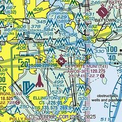
|
| Airport distance calculator |
|---|
|
|
| Sunrise and sunset |
|---|
|
Times for 07-Dec-2025
| | Local
(UTC-6) | | Zulu
(UTC) |
|---|
| Morning civil twilight | | 06:37 | | 12:37 |
| Sunrise | | 07:03 | | 13:03 |
| Sunset | | 17:20 | | 23:20 |
| Evening civil twilight | | 17:46 | | 23:46 |
|
| Current date and time |
|---|
| Zulu (UTC) | 07-Dec-2025 16:28:00 |
|---|
| Local (UTC-6) | 07-Dec-2025 10:28:00 |
|---|
|
| METAR |
|---|
KEFD
7nm SW | 071554Z 00000KT 5SM OVC004 19/19 A2992
|
KHOU
12nm W | 071609Z 27005KT 1 1/2SM BR OVC003 19/18 A2993 RMK AO2 CIG 002V008 T01890183 $
|
KLVJ
13nm SW | 071601Z AUTO 29004KT 3SM BR OVC003 19/19 A2995 RMK AO2 T01890189
|
|
| TAF |
|---|
KEFD
7nm SW | 071200Z 0712/0818 00000KT 0400 FG VV002 QNH2988INS BECMG 0717/0718 28006KT 8000 BR BKN010 OVC017 QNH2987INS BECMG 0721/0722 33012G25KT 9999 NSW SCT032 QNH2995INS TX21/0721Z TN09/0810Z
|
KHOU
12nm W | 071130Z 0712/0812 VRB02KT 3/4SM BR OVC001 FM071500 VRB02KT 2SM BR OVC007 FM071900 31012G23KT P6SM FEW007 SCT025 BKN250 FM080000 34016G25KT P6SM SCT250 FM080900 36011KT P6SM FEW250
|
|
| NOTAMs |
|---|
NOTAMs are issued by the DoD/FAA and will open in a separate window not controlled by AirNav.
|
|


