FAA INFORMATION EFFECTIVE 25 DECEMBER 2025
Location
| FAA Identifier: | TOA |
| Lat/Long: | 33-48-12.1783N 118-20-22.5875W
33-48.202972N 118-20.376458W
33.8033829,-118.3396076
(estimated) |
| Elevation: | 103.2 ft. / 31.5 m (surveyed) |
| Variation: | 14E (1970) |
| From city: | 3 miles SW of TORRANCE, CA |
| Time zone: | UTC -8 (UTC -7 during Daylight Saving Time) |
| Zip code: | 90505 |
Airport Operations
| Airport use: | Open to the public |
| Control tower: | yes |
| ARTCC: | LOS ANGELES CENTER |
| FSS: | HAWTHORNE FLIGHT SERVICE STATION |
| NOTAMs facility: | TOA (NOTAM-D service available) |
| Attendance: | 0600-2200 |
| Wind indicator: | lighted |
| Segmented circle: | yes |
| Lights: | WHEN ATCT CLSD ACTVT MALSR RY 29R - CTAF; MIRL RY 11L/29R SS-SR; MIRL RY 11R/29L 0600-2000; ACTVT HELIPAD PERIMETER LGTS - 24 HRS - CTAF. VASI RWY 29L OPER CONSLY. |
| Beacon: | white-green (lighted land airport)
Operates sunset to sunrise. |
| Landing fee: | yes, FOR LDG FEE SKED, CTC ARPT OR CHECK ARPT WEBSITE. MIL, PUB SAFETY, AND MED OPS SHALL BE EXEMPT FROM LDG FEES. |
Airport Communications
| CTAF: | 124.0 |
| UNICOM: | 122.95 |
| ATIS: | 125.6 |
| TORRANCE GROUND: | 120.9 [0700-2000] |
| TORRANCE TOWER: | 124.0 ;SOUTH 133.075 ;NORTH 257.8 [0700-2000] |
| SOCAL APPROACH: | 124.3 ;RWY 11L, 11R 127.2 ;RWY 29L/R |
| SOCAL DEPARTURE: | 124.3 ;RWY 29L, 29R 127.2 ;RWY 11L/R |
| HAWWC DP: | 127.2 ;RWY 11L/R 134.9 ;RWY 29L/R |
| IC: | 257.8 |
| WX AWOS-3PT at CPM (7 nm NE): | 127.150 (310-631-3022) |
| WX ASOS at HHR (7 nm N): | PHONE 310-973-8930 |
| WX ASOS at LAX (9 nm N): | PHONE 310-602-6051 |
| WX ASOS at LGB (9 nm E): | PHONE 562-247-0378 |
| WX ASOS at SMO (14 nm NW): | PHONE 310-392-6453 |
| WX ASOS at FUL (18 nm E): | PHONE 714-870-1372 |
- TWR SECTORIZATION IS BASED ON CENTER OF ARPT PARALLEL TO RY 11/29 CNTRLN.
Nearby radio navigation aids
| VOR radial/distance | | VOR name | | Freq | | Var |
|---|
| LAXr134/9.0 | | LOS ANGELES VORTAC | | 113.60 | | 15E |
| SMOr140/13.7 | | SANTA MONICA VOR/DME | | 110.80 | | 15E |
| SLIr260/14.3 | | SEAL BEACH VORTAC | | 115.70 | | 15E |
| SXCr354/26.0 | | SANTA CATALINA VORTAC | | 114.15 | | 15E |
| VNYr148/26.3 | | VAN NUYS VOR/DME | | 113.10 | | 15E |
| ELBr270/31.3 | | EL TORO VOR/DME | | 117.20 | | 14E |
| POMr224/32.1 | | POMONA VORTAC | | 110.40 | | 15E |
| VTUr103/40.0 | | VENTURA VOR/DME | | 116.55 | | 15E |
Airport Services
| Fuel available: | 100LL
100LL:FUEL AVBL 0700-2000. |
| Parking: | tiedowns |
| Airframe service: | MAJOR |
| Powerplant service: | MAJOR |
| Bottled oxygen: | HIGH/LOW |
| Bulk oxygen: | HIGH/LOW |
Runway Information
Runway 11L/29R
| Dimensions: | 5001 x 150 ft. / 1524 x 46 m |
| Surface: | asphalt/concrete, in fair condition |
| Weight bearing capacity: | | Single wheel: | 30.0 | | Double wheel: | 50.0 | | Double tandem: | 90.0 |
|
| Runway edge lights: | medium intensity |
| RUNWAY 11L | | RUNWAY 29R |
| Latitude: | 33-48.483555N | | 33-47.970732N |
| Longitude: | 118-20.740110W | | 118-19.966660W |
| Elevation: | 83.0 ft. | | 96.8 ft. |
| Traffic pattern: | left | | right |
| Runway heading: | 114 magnetic, 128 true | | 294 magnetic, 308 true |
| Displaced threshold: | 541 ft. | | 540 ft. |
| Markings: | precision, in fair condition | | precision, in fair condition |
| Visual slope indicator: | 2-box VASI on left (3.50 degrees glide path) | | 4-box VASI on left (4.00 degrees glide path) |
| Approach lights: | | | MALSR: 1,400 foot medium intensity approach lighting system with runway alignment indicator lights |
| Runway end identifier lights: | no | | no |
| Touchdown point: | yes, no lights | | yes, no lights |
| Instrument approach: | | | ILS/DME |
| Obstructions: | 35 ft. trees, 690 ft. from runway, 14:1 slope to clear
RWY 11L APCH RATIO TO DSPLCD THR 35:1; | | 22 ft. bldg, 475 ft. from runway, 530 ft. left of centerline, 12:1 slope to clear
+9 FT MALSR BLDG 190 FT FROM E OR 440 FT RIGHT. |
Runway 11R/29L
| Dimensions: | 3000 x 75 ft. / 914 x 23 m |
| Surface: | asphalt/concrete, in fair condition |
| Weight bearing capacity: | |
| Runway edge lights: | medium intensity |
| RUNWAY 11R | | RUNWAY 29L |
| Latitude: | 33-48.316468N | | 33-48.008890N |
| Longitude: | 118-20.646902W | | 118-20.182938W |
| Elevation: | 96.3 ft. | | 103.2 ft. |
| Traffic pattern: | right | | left |
| Runway heading: | 114 magnetic, 128 true | | 294 magnetic, 308 true |
| Markings: | basic, in fair condition | | basic, in fair condition |
| Visual slope indicator: | | | 2-box VASI on left (4.00 degrees glide path)
UNUSBL BYD 2 DEG RIGHT & 9 DEG LEFT OF RWY CNTRLN. |
| Runway end identifier lights: | | | yes |
| Touchdown point: | yes, no lights | | yes, no lights |
| Obstructions: | none | | 26 ft. bldg, lighted, 1400 ft. from runway, 100 ft. left of centerline, 46:1 slope to clear |
Helipad H1
| Dimensions: | 110 x 110 ft. / 34 x 34 m |
| Surface: | asphalt, in good condition
FATO AND TLOF PAVED. |
| Runway edge lights: | PERI
YELLOW PERIMETER LGTS. |
| Latitude: | 33-48.556333N | | |
| Longitude: | 118-20.739667W | | |
| Elevation: | 79.0 ft. | | |
| Traffic pattern: | left | | left |
Airport Ownership and Management from official FAA records
| Ownership: | Publicly-owned |
| Owner: | CITY OF TORRANCE
3031 TORRANCE BLVD
TORRANCE, CA 90503
Phone 310-784-7900 |
| Manager: | RAFAEL HERRERA
CITY OF TORRANCE, 3301 AIRPORT DRIVE
TORRANCE, CA 90505
Phone 310-784-7914 |
Additional Remarks
| - | NUMEROUS FLOCKS OF BIRDS ON AND INVOF ARPT. |
| - | FOR CD WHEN ATCT CLSD CTC SOCAL APCH AT 800-448-3724. |
| - | LNDG FAC IS FQTLY USED FOR MED AMBULANCE PURPOSES. |
| - | TSNT PRKG LCTD AT THE BASE OF THE ATCT. GREEN BOX WHITE T FOR SMALL ACFT; BLUE BOX WHITE T FOR JETS. |
| - | NO TGL OR STOP & GO OPS PMTD. NO LOW APCH OR FULL STOP TAXI-BACK PMTD BTN 1800-1000 MON-FRI. NO LOW APCH OR FULL STOP TAXI-BACK PMTD SAT, SUN BTN FRI 1800 & MON 1000, OR HOLS. ARPT CLSD TO DEP 2200-0700 WKDAYS & 2200-0800 WKENDS & HOLS. |
| - | NO MULTI-ENGINE SIMULATED ENGINE-OUT PROCS AUTH IN TFC PAT. RY 11R/29L CLSD 2000-0700. |
| - | NOISE SENSITIVE AREA ALL QUADS. FOR NOISE ABATEMENT PROCS INFO CTC ARPT NOISE ABATEMENT (310) 784-7950. CERTAIN TBJT ACFT PERMLY EXCLDD. |
| - | AT TWYS HOTEL & CHARLIE OBS TWY HOLD LINES. ALL ACFT MUST HOLD BTN THE SET OF HOLD BARS FOR THE APCH ZONE FOR RWY 11R/29L. |
| - | BE ALERT TO PSNL & EQPT OPRG NEAR ALL RWYS AND TWYS. |
Instrument Procedures
NOTE: All procedures below are presented as PDF files. If you need a reader for these files, you should download the free Adobe Reader.NOT FOR NAVIGATION. Please procure official charts for flight.
FAA instrument procedures published for use from 25 December 2025 at 0901z to 22 January 2026 at 0900z.
STARs - Standard Terminal Arrivals |
|---|
| KAYOH EIGHT | |
download (268KB) |
IAPs - Instrument Approach Procedures |
|---|
| ILS OR LOC RWY 29R **CHANGED** | |
download (335KB) |
| RNAV (GPS) RWY 11L **CHANGED** | |
download (268KB) |
| RNAV (GPS) RWY 29R **CHANGED** | |
download (296KB) |
| VOR RWY 11L **CHANGED** | |
download (266KB) |
| NOTE: Special Alternate Minimums apply | |
download (115KB) |
Departure Procedures |
|---|
| HAWWC THREE (RNAV) | |
download (163KB) |
| NOTE: Special Take-Off Minimums/Departure Procedures apply | |
download (350KB) |
Other nearby airports with instrument procedures:
KHHR - Jack Northrop Field/Hawthorne Municipal Airport (7 nm N)
KLAX - Los Angeles International Airport (9 nm N)
KLGB - Long Beach Airport (Daugherty Field) (9 nm E)
KSMO - Santa Monica Municipal Airport (14 nm NW)
KSLI - Los Alamitos Army Airfield (14 nm E)
KFUL - Fullerton Municipal Airport (18 nm E)
|
|

Road maps at:
MapQuest
Bing
Google
| Aerial photo |
|---|
WARNING: Photo may not be current or correct
 Photo by www.focalflight.com
Photo taken 03-Jun-2020
looking west-northwest.
Photo by www.focalflight.com
Photo taken 03-Jun-2020
looking west-northwest.
Do you have a better or more recent aerial photo of Zamperini Field Airport that you would like to share? If so, please send us your photo.
|
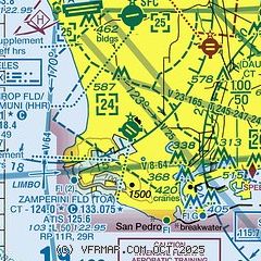
| Sectional chart |
|---|
|
CAUTION: Diagram may not be current
 Download PDF
of official airport diagram from the FAA
| Airport distance calculator |
|---|
|
|
| Sunrise and sunset |
|---|
|
Times for 20-Jan-2026
| | Local
(UTC-8) | | Zulu
(UTC) |
|---|
| Morning civil twilight | | 06:31 | | 14:31 |
| Sunrise | | 06:58 | | 14:58 |
| Sunset | | 17:11 | | 01:11 |
| Evening civil twilight | | 17:38 | | 01:38 |
|
| Current date and time |
|---|
| Zulu (UTC) | 20-Jan-2026 18:58:19 |
|---|
| Local (UTC-8) | 20-Jan-2026 10:58:19 |
|---|
|
| METAR |
|---|
KTOA
2nm SE | 201847Z 26004KT 10SM SCT160 SCT250 21/05 A3011
|
KHHR
7nm N | 201853Z 00000KT 10SM CLR 23/01 A3011 RMK AO2 SLP193 T02280006 $
|
KLAX
8nm N | 201853Z 26010KT 10SM FEW010 SCT160 BKN250 19/14 A3011 RMK AO2 SLP195 T01890139 $
|
KLGB
9nm E | 201853Z 00000KT 9SM CLR 19/11 A3010 RMK AO2 SLP192 T01940106
|
KSMO
14nm NW | 201851Z 22004KT 10SM CLR 20/09 A3011 RMK AO2 SLP195 T02000089
|
KSLI
15nm E | 201755Z 00000KT 10SM BKN250 16/12 A3007 RMK AO2A SLP186 T01610117 10163 20045 52017
|
KFUL
18nm E | 201853Z 00000KT 10SM CLR 19/12 A3010 RMK AO2 SLP191 T01890117
|
|
| TAF |
|---|
KLAX
8nm N | 201745Z 2018/2124 09004KT P6SM SCT250 FM202100 26008KT P6SM SCT250 FM210300 VRB03KT P6SM SCT250 FM210700 VRB03KT 2SM BR VCFG BKN004 FM211800 VRB03KT 6SM BR SCT005 FM212100 26007KT P6SM BKN250
|
KLGB
9nm E | 201720Z 2018/2118 VRB03KT P6SM SCT250 FM202200 19005KT P6SM SCT250 FM210100 VRB03KT P6SM SCT250 FM210700 VRB03KT 2SM BR VCFG BKN004
|
KSMO
14nm NW | 201720Z 2018/2118 VRB03KT P6SM SCT250 FM202100 22006KT P6SM FEW250 FM210200 VRB03KT P6SM FEW250 FM210800 VRB03KT 2SM BR VCFG BKN004
|
KSLI
15nm E | 201418Z 2014/2119 00000KT 9999 FEW250 QNH3001INS BECMG 2017/2018 VRB05KT 9999 SKC QNH3013INS BECMG 2106/2107 VRB03KT 8000 BR FEW005 QNH3007INS TEMPO 2110/2113 4800 BR BECMG 2114/2115 09003KT 9000 BR SCT005 QNH3007INS TX22/2100Z TN07/2014Z
|
|
| NOTAMs |
|---|
NOTAMs are issued by the DoD/FAA and will open in a separate window not controlled by AirNav.
|
|


