FAA INFORMATION EFFECTIVE 31 OCTOBER 2024
Location
| FAA Identifier: | MLE |
| Lat/Long: | 41-11-45.5500N 096-06-44.1530W
41-11.759167N 096-06.735883W
41.1959861,-96.1122647
(estimated) |
| Elevation: | 1050.7 ft. / 320.3 m (surveyed) |
| Variation: | 06E (1990) |
| From city: | 7 miles SW of OMAHA, NE |
| Time zone: | UTC -5 (UTC -6 during Standard Time) |
| Zip code: | 68137 |
Airport Operations
| Airport use: | Open to the public |
| Control tower: | no |
| ARTCC: | MINNEAPOLIS CENTER |
| FSS: | COLUMBUS FLIGHT SERVICE STATION |
| NOTAMs facility: | MLE (NOTAM-D service available) |
| Attendance: | 0630-2100
FOR SVC AFT 2100 CALL 402-953-9905 OR 402-690-3099. |
| Wind indicator: | lighted |
| Segmented circle: | no |
| Lights: | ACTVT MIRL RY 12/30 & REIL RY 12 - CTAF. |
| Beacon: | white-green (lighted land airport)
Operates sunset to sunrise. |
Airport Communications
| CTAF/UNICOM: | 123.0 |
| WX AWOS-3: | 118.25 (402-895-6778) |
| OMAHA APPROACH: | 120.1 |
| OMAHA DEPARTURE: | 120.1 |
| CLEARANCE DELIVERY: | 125.4 |
| WX ASOS at OMA (12 nm NE): | PHONE 402-271-7515 |
| WX AWOS-3 at BTA (13 nm N): | 120.225 (402-426-0448) |
| WX AWOS-3 at CBF (16 nm E): | 126.575 (712-323-1542) |
| WX AWOS-3 at PMV (17 nm SE): | 118.975 (402-298-7524) |
- A CONTINUOUS TRANSCRIBED BROADCAST FOR MILLARD ARPT WHICH INCLUDES TEMPERATURE / DEWPOINT / WIND SPEED AND DIRECTION; AND ALTIMETER SETTING IS AVAILABLE ON FREQ 118.25 OR BY TELEPHONE (402) 895-6778.
Nearby radio navigation aids
| VOR radial/distance | | VOR name | | Freq | | Var |
|---|
| OVRr268/17.0 | | OMAHA VORTAC | | 116.30 | | 08E |
| LNKr051/32.8 | | LINCOLN VORTAC | | 116.10 | | 09E |
| SCBr131/33.8 | | SCRIBNER VOR/DME | | 111.00 | | 06E |
| NDB name | | Hdg/Dist | | Freq | | Var | | ID |
|---|
| PLATTSMOUTH | | 324/17.6 | | 329 | | 05E | | PMV | .--. -- ...- |
| WAHOO | | 091/22.1 | | 400 | | 06E | | AHQ | .- .... --.- |
| NEBRASKA CITY | | 337/37.2 | | 347 | | 05E | | AFK | .- ..-. -.- |
Airport Services
| Fuel available: | 100LL JET-A1+ |
| Parking: | hangars and tiedowns |
| Airframe service: | MAJOR |
| Powerplant service: | MAJOR |
| Bottled oxygen: | HIGH/LOW |
| Bulk oxygen: | HIGH/LOW |
Runway Information
Runway 12/30
| Dimensions: | 3801 x 75 ft. / 1159 x 23 m |
| Surface: | asphalt, in good condition |
| Weight bearing capacity: | | Single wheel: | 25.0 | | Double wheel: | 28.0 |
|
| Runway edge lights: | medium intensity |
| RUNWAY 12 | | RUNWAY 30 |
| Latitude: | 41-11.955133N | | 41-11.563217N |
| Longitude: | 096-07.058867W | | 096-06.412900W |
| Elevation: | 1050.6 ft. | | 1046.0 ft. |
| Traffic pattern: | left | | left |
| Runway heading: | 123 magnetic, 129 true | | 303 magnetic, 309 true |
| Displaced threshold: | 212 ft. | | no |
| Declared distances: | TORA:3801 TODA:3801 ASDA:3801 LDA:3588 | | TORA:3801 TODA:3801 ASDA:3588 LDA:3801 |
| Markings: | nonprecision, in good condition | | nonprecision, in good condition |
| Visual slope indicator: | 2-light PAPI on left (3.08 degrees glide path) | | 2-light PAPI on left (3.08 degrees glide path) |
| Runway end identifier lights: | yes | | |
| Touchdown point: | yes, no lights | | yes, no lights |
| Obstructions: | 17 ft. road, 410 ft. from runway, 285 ft. right of centerline, 12:1 slope to clear
APCH RATIO 36:1 FROM DSPLCD THR | | 57 ft. tree, 824 ft. from runway, 269 ft. right of centerline, 10:1 slope to clear |
Airport Ownership and Management from official FAA records
| Ownership: | Publicly-owned |
| Owner: | OMAHA AIRPORT AUTHORITY
4501 ABBOTT DRIVE, SUITE 2300
OMAHA, NE 68110-2689
Phone 402-661-8000 |
| Manager: | DAVID ROTH
4501 ABBOTT DRIVE, SUITE 2300
OMAHA, NE 68110-2689
Phone 402-661-8000 |
Additional Remarks
| - | MIL JETS OVERFLYING AT 3000 FT MSL. |
| - | AFTER TKOF ON RY 30 ALTER HDG 20 DEGS TO THE R TO AVOID NOISE SENSITIVE AREA. |
| - | NORMAL CALM & CROSS WIND TKOFS & LNDGS OF RY 12; NO INTXN TKOFS. |
| - | RADIO CONTROLLED ACFT OCCASIONAL OPERATION 1.7 MI SW OF ARPT. |
| - | VFR ACFT REQUESTING FLIGHT FLWG & IFR ACFT SHOULD CONTACT OMAHA APCH ON FREQ 125.4 PRIOR TO TAKING THE RY FOR CLNC/TRAFFIC ADVISORIES/GEN INFO. |
| - | DEER ON & INVOF ARPT. |
| - | SELF-SVC FUEL AVBL 24 HRS WITH CREDIT CARD. |
Instrument Procedures
NOTE: All procedures below are presented as PDF files. If you need a reader for these files, you should download the free Adobe Reader.NOT FOR NAVIGATION. Please procure official charts for flight.
FAA instrument procedures published for use from 31 October 2024 at 0901Z to 28 November 2024 at 0900z.
IAPs - Instrument Approach Procedures |
|---|
| RNAV (GPS) RWY 12 | |
download (228KB) |
| RNAV (GPS) RWY 30 | |
download (196KB) |
| NOTE: Special Alternate Minimums apply | |
download (15KB) |
| NOTE: Special Take-Off Minimums/Departure Procedures apply | |
download (147KB) |
Other nearby airports with instrument procedures:
KOFF - Offutt Air Force Base (10 nm SE)
KOMA - Eppley Airfield (12 nm NE)
KBTA - Blair Executive Airport (13 nm N)
KCBF - Council Bluffs Municipal Airport (16 nm E)
KPMV - Plattsmouth Municipal Airport/Douglas V Duey Field (17 nm SE)
|
|

Road maps at:
MapQuest
Bing
Google
| Aerial photo |
|---|
WARNING: Photo may not be current or correct
 Photo by Vicki Eifert
Photo taken 18-Aug-2017
looking northwest.
Photo by Vicki Eifert
Photo taken 18-Aug-2017
looking northwest.
Do you have a better or more recent aerial photo of Millard Airport that you would like to share? If so, please send us your photo.
|
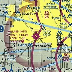
| Sectional chart |
|---|
|
CAUTION: Diagram may not be current

| Airport distance calculator |
|---|
|
|
| Sunrise and sunset |
|---|
|
Times for 25-Nov-2024
| | Local
(UTC-6) | | Zulu
(UTC) |
|---|
| Morning civil twilight | | 06:56 | | 12:56 |
| Sunrise | | 07:26 | | 13:26 |
| Sunset | | 16:57 | | 22:57 |
| Evening civil twilight | | 17:28 | | 23:28 |
|
| Current date and time |
|---|
| Zulu (UTC) | 25-Nov-2024 06:01:20 |
|---|
| Local (UTC-6) | 25-Nov-2024 00:01:20 |
|---|
|
| METAR |
|---|
| KMLE | 250535Z AUTO 32015G19KT 5SM BR OVC007 02/01 A2999 RMK AO2 T00210007
|
KOFF
10nm SE | 250555Z 32017G24KT 10SM OVC007 03/01 A2996 RMK AO2A CIG 005 RWY13 SLP154 T00340011 10089 20034 401400023 52027
|
KOMA
12nm NE | 250552Z 32019G27KT 4SM BR OVC006 02/01 A2998 RMK AO2 PK WND 32028/0524 SLP154 T00220011 10072 20022 401280022 53027
|
KBTA
13nm N | 250535Z AUTO 32018G22KT 4SM BR OVC004 01/01 A2997 RMK AO2 T00120006
|
KCBF
16nm E | 250535Z AUTO 32014G22KT 4SM BR OVC005 02/02 A2992 RMK AO2
|
KPMV
17nm SE | 250515Z AUTO 32018KT 7SM OVC007 03/01 A2994 RMK AO2 T00280011
|
|
| TAF |
|---|
KOFF
10nm SE | 250500Z 2505/2609 33015G25KT 9999 OVC009 QNH2993INS TEMPO 2505/2511 OVC010 BECMG 2510/2511 33015G25KT 9999 BKN030 QNH3007INS BECMG 2512/2513 33015G25KT 9999 SCT030 SCT150 QNH3014INS BECMG 2514/2515 33010G20KT 9999 FEW150 QNH3021INS BECMG 2520/2521 30012G18KT 9999 SKC QNH3025INS BECMG 2600/2601 30012KT 9999 SKC QNH3030INS TX04/2505Z TNM01/2513Z
|
KOMA
12nm NE | 250520Z 2506/2606 33018G25KT P6SM OVC009 FM250900 33018G25KT P6SM OVC015 FM251200 33018G25KT P6SM SCT050 FM260000 31005KT P6SM SKC
|
|
| NOTAMs |
|---|
NOTAMs are issued by the DoD/FAA and will open in a separate window not controlled by AirNav.
|
|


