FAA INFORMATION EFFECTIVE 23 JANUARY 2025
Location
| FAA Identifier: | N14 |
| Lat/Long: | 39-56-03.4000N 074-48-26.0000W
39-56.056667N 074-48.433333W
39.9342778,-74.8072222
(estimated) |
| Elevation: | 49.3 ft. / 15.0 m (surveyed) |
| Variation: | 13W (2000) |
| From city: | 1 mile SW of LUMBERTON, NJ |
| Time zone: | UTC -5 (UTC -4 during Daylight Saving Time) |
| Zip code: | 08055 |
Airport Operations
| Airport use: | Open to the public |
| Activation date: | 04/1984 |
| Control tower: | no |
| ARTCC: | NEW YORK CENTER |
| FSS: | MILLVILLE FLIGHT SERVICE STATION |
| NOTAMs facility: | MIV (NOTAM-D service available) |
| Attendance: | APR-OCT 0700-2100, NOV-MAR 0700-1900 |
| Wind indicator: | lighted |
| Segmented circle: | yes |
| Lights: | ACTVT MIRL, PAPI, REIL AND TWY LGTS - CTAF. |
| Beacon: | white-green (lighted land airport)
Operates sunset to sunrise. |
Airport Communications
| CTAF/UNICOM: | 122.8 |
| MC GUIRE APPROACH: | 126.475 |
| MC GUIRE DEPARTURE: | 126.475 |
| WX ASOS at VAY (1.8 nm W): | 119.325 (609-267-1176) |
| WX ASOS at PNE (13 nm NW): | PHONE 215-897-9068 |
| WX AWOS-AV at N81 (16 nm S): | 122.7 |
Nearby radio navigation aids
| VOR radial/distance | | VOR name | | Freq | | Var |
|---|
| GXUr257/10.7 | | MC GUIRE VORTAC | | 110.60 | | 12W |
| CYNr302/18.7 | | COYLE VORTAC | | 113.40 | | 10W |
| ARDr176/19.7 | | YARDLEY VOR/DME | | 108.20 | | 10W |
| RBVr232/21.5 | | ROBBINSVILLE VORTAC | | 113.80 | | 10W |
| VCNr027/24.9 | | CEDAR LAKE VOR/DME | | 115.20 | | 10W |
| OODr062/29.0 | | WOODSTOWN VORTAC | | 112.80 | | 10W |
| ACYr350/30.6 | | ATLANTIC CITY VORTAC | | 117.15 | | 10W |
| COLr244/37.4 | | COLTS NECK VOR/DME | | 115.40 | | 11W |
| PTWr126/38.6 | | POTTSTOWN VORTAC | | 116.50 | | 09W |
| SBJr194/39.0 | | SOLBERG VOR/DME | | 112.90 | | 10W |
| MXEr098/39.7 | | MODENA VORTAC | | 113.20 | | 09W |
| DQOr077/39.9 | | DUPONT VORTAC | | 114.00 | | 10W |
| NDB name | | Hdg/Dist | | Freq | | Var | | ID |
|---|
| LAKEHURST | | 264/22.7 | | 396 | | 11W | | NEL | -. . .-.. |
| RAINBOW | | 037/34.5 | | 363 | | 11W | | RNB | .-. -. -... |
Airport Services
| Fuel available: | 100LL JET-A |
| Parking: | tiedowns |
| Airframe service: | MINOR |
| Powerplant service: | MINOR |
| Bottled oxygen: | NONE |
| Bulk oxygen: | NONE |
Runway Information
Runway 1/19
| Dimensions: | 3496 x 75 ft. / 1066 x 23 m |
| Surface: | asphalt, in fair condition |
| Runway edge lights: | medium intensity |
| RUNWAY 1 | | RUNWAY 19 |
| Latitude: | 39-55.769555N | | 39-56.344903N |
| Longitude: | 074-48.417490W | | 074-48.447527W |
| Elevation: | 35.0 ft. | | 49.1 ft. |
| Traffic pattern: | right | | left |
| Runway heading: | 011 magnetic, 358 true | | 191 magnetic, 178 true |
| Markings: | nonprecision, in good condition | | nonprecision, in good condition |
| Visual slope indicator: | 2-light PAPI on left (3.50 degrees glide path) | | 2-light PAPI on left (3.20 degrees glide path) |
| Runway end identifier lights: | yes
REILS INOP. | | yes
REILS INOP. |
| Touchdown point: | yes, no lights | | yes, no lights |
| Obstructions: | 89 ft. trees, 262 ft. from runway, 169 ft. right of centerline
TREE, +42 FT HIGH, 43 FT FM THLD, 102 FT R. | | none |
Airport Ownership and Management from official FAA records
| Ownership: | Privately-owned |
| Owner: | CAVE HOLDINGS-FLYING W, LLC
60 FOSTERTOWN RD
MEDFORD, NJ 08055
Phone 609-261-7880 |
| Manager: | MINDY KIMBALL
60 FOSTERTOWN RD
MEDFORD, NJ 08055
Phone 609-267-7673 |
Additional Remarks
| - | EAST-WEST RAVINE CROSSES EXTD CNTRLN RWY 01, 100 FT FM THLD. |
| - | DEEP RETENTION POND 23 FT WEST OF PARALLEL TWY CNTRLN, NORTH OF OPS BLDG. |
| - | FOR CD CTC MC GUIRE APCH AT 609-754-2767. |
| - | DEER & BIRDS ON & INVOF ARPT. |
Instrument Procedures
NOTE: All procedures below are presented as PDF files. If you need a reader for these files, you should download the free Adobe Reader.NOT FOR NAVIGATION. Please procure official charts for flight.
FAA instrument procedures published for use from 23 January 2025 at 0901Z to 20 February 2025 at 0900z.
STARs - Standard Terminal Arrivals |
|---|
| WAALK TWO (RNAV) | |
2 pages:
[1] [2] (285KB) |
IAPs - Instrument Approach Procedures |
|---|
| RNAV (GPS) RWY 01 | |
download (175KB) |
| RNAV (GPS) RWY 19 | |
download (239KB) |
| VOR-A | |
download (192KB) |
| NOTE: Special Take-Off Minimums/Departure Procedures apply | |
download (150KB) |
Other nearby airports with instrument procedures:
KVAY - South Jersey Regional Airport (2 nm W)
KWRI - McGuire Field (Joint Base Mc Guire Dix Lakehurst) Airport (11 nm NE)
19N - Pine Valley Airport (11 nm SW)
KPNE - Northeast Philadelphia Airport (13 nm NW)
N81 - Hammonton Municipal Airport (16 nm S)
17N - Cross Keys Airport (17 nm SW)
N87 - Trenton-Robbinsville Airport (19 nm NE)
|
|

Road maps at:
MapQuest
Bing
Google
| Aerial photo |
|---|
WARNING: Photo may not be current or correct
 Photo by David Newcomer
Photo taken 19-Jan-2013
looking northeast from 3,000' AGL.
Photo by David Newcomer
Photo taken 19-Jan-2013
looking northeast from 3,000' AGL.
Do you have a better or more recent aerial photo of Flying W Airport that you would like to share? If so, please send us your photo.
|
| Sectional chart |
|---|
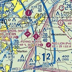
|
| Airport distance calculator |
|---|
|
|
| Sunrise and sunset |
|---|
|
Times for 02-Feb-2025
| | Local
(UTC-5) | | Zulu
(UTC) |
|---|
| Morning civil twilight | | 06:39 | | 11:39 |
| Sunrise | | 07:08 | | 12:08 |
| Sunset | | 17:18 | | 22:18 |
| Evening civil twilight | | 17:47 | | 22:47 |
|
| Current date and time |
|---|
| Zulu (UTC) | 02-Feb-2025 08:48:03 |
|---|
| Local (UTC-5) | 02-Feb-2025 03:48:03 |
|---|
|
| METAR |
|---|
| KVAY | ASOS 119.325 609-267-1176
020754Z AUTO 02004KT 10SM CLR M07/M16 A3055 RMK AO2 SLP346 T10721161
|
KWRI
11nm NE | 020755Z AUTO 03005KT 10SM CLR M08/M16 A3053 RMK AO2 SLP340 T10761158 $
|
KPNE
13nm NW | 020754Z AUTO 02006KT 10SM CLR M07/M17 A3056 RMK AO2 SLP351 T10721167 TSNO $
|
|
| TAF |
|---|
KWRI
11nm NE | 020200Z 0202/0308 35009KT 9999 SKC QNH3035INS BECMG 0210/0211 06010KT 9999 FEW020 SCT120 QNH3053INS BECMG 0214/0215 VRB06KT 9999 SCT020 QNH3025INS BECMG 0221/0222 15007KT 9999 FEW019 BKN025 OVC055 QNH3025INS TX04/0219Z TNM02/0211Z
|
KPNE
13nm NW | 020525Z 0206/0306 04005KT P6SM FEW250 FM021600 12007KT P6SM BKN250 FM030100 VRB04KT P6SM OVC050
|
|
| NOTAMs |
|---|
NOTAMs are issued by the DoD/FAA and will open in a separate window not controlled by AirNav.
|
|


