FAA INFORMATION EFFECTIVE 15 MAY 2025
Location
| FAA Identifier: | 1G5 |
| Lat/Long: | 41-07-53.2000N 081-45-53.6000W
41-07.886667N 081-45.893333W
41.1314444,-81.7648889
(estimated) |
| Elevation: | 1189.8 ft. / 362.7 m (surveyed) |
| Variation: | 07W (1990) |
| From city: | 4 miles E of MEDINA, OH |
| Time zone: | UTC -4 (UTC -5 during Standard Time) |
| Zip code: | 44256 |
Airport Operations
| Airport use: | Open to the public |
| Control tower: | no |
| ARTCC: | CLEVELAND CENTER |
| FSS: | CLEVELAND FLIGHT SERVICE STATION |
| NOTAMs facility: | CLE (NOTAM-D service available) |
| Attendance: | APR-OCT 0800-2000, NOV-MAR 0800-1700 |
| Wind indicator: | lighted |
| Segmented circle: | yes |
| Lights: | ACTVT REIL RWY 27; PAPI RWY 01, 19, & 27; MIRL RWY 01/19 & 09/27 - CTAF. PAPI RWY 01, 19, & 27 OPR CONSLY DUSK-2200. |
| Beacon: | white-green (lighted land airport)
Operates sunset to sunrise. |
Airport Communications
| CTAF/UNICOM: | 123.0 |
| CLEVELAND APPROACH: | 125.35 |
| CLEVELAND DEPARTURE: | 125.35 |
| WX ASOS at AKR (15 nm SE): | 126.825 (330-724-4237) |
| WX AWOS-2 at 1G3 (16 nm E): | 119.15 (330-346-1497) |
| WX ASOS at BJJ (16 nm S): | 118.075 (330-669-9105) |
| WX ASOS at CLE (17 nm N): | PHONE 216-416-2729 |
| WX ASOS at CAK (19 nm SE): | PHONE 330-227-8682 |
Nearby radio navigation aids
| VOR radial/distance | | VOR name | | Freq | | Var |
|---|
| DJBr132/22.5 | | DRYER VOR/DME | | 113.60 | | 05W |
| ACOr277/25.5 | | AKRON VOR/DME | | 114.40 | | 04W |
| BSVr331/27.9 | | BRIGGS VOR/DME | | 114.05 | | 04W |
| CXRr235/35.6 | | CHARDON VOR/DME | | 112.70 | | 05W |
Airport Services
| Fuel available: | 100LL JET-A+
100LL:AVBL H24 SELF SER. |
| Parking: | hangars and tiedowns |
| Airframe service: | MAJOR |
| Powerplant service: | MAJOR |
Runway Information
Runway 9/27
| Dimensions: | 3556 x 75 ft. / 1084 x 23 m |
| Surface: | asphalt, in good condition |
| Weight bearing capacity: | |
| Runway edge lights: | medium intensity |
| RUNWAY 9 | | RUNWAY 27 |
| Latitude: | 41-07.881618N | | 41-07.946467N |
| Longitude: | 081-46.425062W | | 081-45.655383W |
| Elevation: | 1168.8 ft. | | 1182.8 ft. |
| Traffic pattern: | left | | left |
| Runway heading: | 091 magnetic, 084 true | | 271 magnetic, 264 true |
| Markings: | nonprecision, in good condition | | nonprecision, in good condition |
| Visual slope indicator: | 4-light PAPI on left (3.00 degrees glide path)
U/S INDEFLY. | | 4-light PAPI on left (3.50 degrees glide path) |
| Runway end identifier lights: | | | yes |
| Touchdown point: | yes, no lights | | yes, no lights |
| Obstructions: | 20 ft. tree, 478 ft. from runway, 36 ft. right of centerline, 13:1 slope to clear
+4-6 FT BRUSH, 100-200 FT DIST, 180-200 FT R. | | none |
Runway 1/19
| Dimensions: | 2868 x 60 ft. / 874 x 18 m |
| Surface: | asphalt, in fair condition |
| Weight bearing capacity: | |
| Runway edge lights: | medium intensity |
| RUNWAY 1 | | RUNWAY 19 |
| Latitude: | 41-07.616738N | | 41-08.088963N |
| Longitude: | 081-45.718333W | | 081-45.707340W |
| Elevation: | 1170.1 ft. | | 1189.8 ft. |
| Traffic pattern: | left | | left |
| Runway heading: | 008 magnetic, 001 true | | 188 magnetic, 181 true |
| Displaced threshold: | no | | 737 ft. |
| Markings: | basic, in good condition | | basic, in good condition |
| Visual slope indicator: | 4-light PAPI on left (3.00 degrees glide path) | | 4-light PAPI on left (4.00 degrees glide path) |
| Touchdown point: | yes, no lights | | yes, no lights |
| Obstructions: | 15 ft. pline, marked, 450 ft. from runway, 16:1 slope to clear | | 71 ft. trees, 610 ft. from runway, 175 ft. left of centerline, 5:1 slope to clear
APCH SLP 16:1 DUE TO +71 FT TREE, 1347 FT FM DTHR. |
Airport Ownership and Management from official FAA records
| Ownership: | Publicly-owned |
| Owner: | CITY OF MEDINA
PO BOX 703
MEDINA, OH 44258-0703
Phone 330-725-8861 |
| Manager: | GREG HUBER
PO BOX 703
MEDINA, OH 44258-0703
Phone 330-239-1606 |
Additional Remarks
| - | DEER, BIRDS, & OTR WILDLIFE ON & INVOF ARPT. |
| - | FOR CD CTC CLEVELAND APCH AT 216-352-2323. |
| - | NOISE-SENSITIVE RES & LIVESTOCK AREA INVOF ARPT, DEPS RCMDD TO FLY RWY HDG TIL RCHG TPA. |
Instrument Procedures
NOTE: All procedures below are presented as PDF files. If you need a reader for these files, you should download the free Adobe Reader.NOT FOR NAVIGATION. Please procure official charts for flight.
FAA instrument procedures published for use from 15 May 2025 at 0901Z to 13 June 2025 at 0900z.
IAPs - Instrument Approach Procedures |
|---|
| RNAV (GPS) RWY 09 | |
download (171KB) |
| RNAV (GPS) RWY 27 | |
download (170KB) |
| VOR RWY 27 | |
download (202KB) |
| NOTE: Special Take-Off Minimums/Departure Procedures apply | |
download (164KB) |
Other nearby airports with instrument procedures:
3G3 - Wadsworth Municipal Airport (8 nm S)
KAKR - Akron Fulton International Airport (15 nm SE)
1G3 - Kent State University Airport (16 nm E)
KBJJ - Wayne County Airport (16 nm S)
KCLE - Cleveland-Hopkins International Airport (17 nm N)
1G1 - Elyria Airport (19 nm NW)
KCAK - Akron-Canton Regional Airport (19 nm SE)
|
|

Road maps at:
MapQuest
Bing
Google
| Aerial photo |
|---|
WARNING: Photo may not be current or correct

Do you have a better or more recent aerial photo of Medina Municipal Airport that you would like to share? If so, please send us your photo.
|
| Sectional chart |
|---|
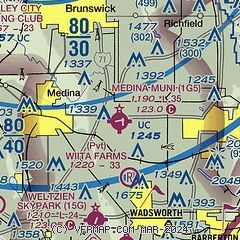
|
| Airport distance calculator |
|---|
|
|
| Sunrise and sunset |
|---|
|
Times for 30-May-2025
| | Local
(UTC-4) | | Zulu
(UTC) |
|---|
| Morning civil twilight | | 05:26 | | 09:26 |
| Sunrise | | 05:59 | | 09:59 |
| Sunset | | 20:50 | | 00:50 |
| Evening civil twilight | | 21:23 | | 01:23 |
|
| Current date and time |
|---|
| Zulu (UTC) | 30-May-2025 12:24:34 |
|---|
| Local (UTC-4) | 30-May-2025 08:24:34 |
|---|
|
| METAR |
|---|
KAKR
15nm SE | 301154Z AUTO 23003KT 10SM CLR 14/12 A2981 RMK AO2 SLP091 T01390117 10139 20089 56013
|
KBJJ
17nm S | 301156Z AUTO 00000KT 7SM OVC110 13/11 A2983 RMK AO2 SLP098 T01280111 10128 20083 56014
|
KCLE
18nm N | 301151Z 27004KT 10SM BKN140 BKN250 13/11 A2980 RMK AO2 SLP105 T01280111 10133 20111 56013
|
KCAK
19nm SE | 301151Z 28004KT 9SM SCT120 BKN160 13/11 A2982 RMK AO2 SLP095 T01280111 10133 20094 56013
|
KLPR
23nm NW | 301153Z AUTO 25003KT 9SM BKN120 13/12 A2982 RMK AO2 SLP097 T01330117 10133 20100 56011 PWINO
|
KPOV
24nm E | 301155Z AUTO 00000KT 10SM CLR 13/11 A2982 RMK AO2 T01260106 PWINO
|
KBKL
25nm N | 301153Z 24007KT 10SM CLR 15/12 A2980 RMK AO2 SLP089 T01500117 10156 20133 56013
|
KCGF
29nm NE | 301145Z 27007KT 10SM CLR 16/13 A2981
|
|
| TAF |
|---|
KCLE
18nm N | 301124Z 3012/3118 21005KT P6SM BKN150 BKN200 FM301500 28008KT P6SM FEW050 SCT090 BKN150 FM310200 28008KT P6SM -SHRA SCT020 BKN050 FM310800 31012KT P6SM -SHRA SCT008 OVC020 FM311400 33015G22KT P6SM BKN030
|
KCAK
19nm SE | 301124Z 3012/3112 VRB04KT P6SM FEW050 SCT090 BKN200 FM301800 30007KT P6SM -SHRA BKN050 OVC090 FM302300 28006KT P6SM SCT050 BKN090 FM310400 28006KT P6SM -SHRA SCT020 OVC050 FM310700 30010KT P6SM -SHRA SCT008 OVC020
|
|
| NOTAMs |
|---|
NOTAMs are issued by the DoD/FAA and will open in a separate window not controlled by AirNav.
|
|


