FAA INFORMATION EFFECTIVE 20 MARCH 2025
Location
| FAA Identifier: | 2G9 |
| Lat/Long: | 40-02-18.6113N 079-00-55.0671W
40-02.310188N 079-00.917785W
40.0385031,-79.0152964
(estimated) |
| Elevation: | 2275 ft. / 693.4 m (surveyed) |
| Variation: | 10W (2000) |
| From city: | 3 miles NE of SOMERSET, PA |
| Time zone: | UTC -4 (UTC -5 during Standard Time) |
| Zip code: | 15541 |
Airport Operations
| Airport use: | Open to the public |
| Activation date: | 03/1953 |
| Control tower: | no |
| ARTCC: | CLEVELAND CENTER |
| FSS: | ALTOONA FLIGHT SERVICE STATION |
| NOTAMs facility: | AOO (NOTAM-D service available) |
| Attendance: | 0800-1600*
UNATNDD NEW YEARS DAY, EASTER, THANKSGIVING, DAY AFT THANKSGIVING, CHRISTMAS DAY AND ALL FEDERAL HOLS. |
| Wind indicator: | lighted |
| Segmented circle: | yes |
| Lights: | MIRL RWY 07/25 & TWY LGTS ON DUSK-0000; ACTVT REIL RWY 07/25, PAPI RWY 07; PVASI RWY 25; - CTAF. |
| Beacon: | white-green (lighted land airport)
Operates sunset to sunrise. |
Airport Communications
| CTAF/UNICOM: | 122.8 |
| WX AWOS-3P: | 133.8 (814-443-2114) |
| JOHNSTOWN APPROACH: | 121.2 |
| JOHNSTOWN DEPARTURE: | 121.2 |
| WX ASOS at JST (19 nm NE): | PHONE 814-535-3511 |
- APCH/DEP SVC PRVDD BY CLEVELAND ARTCC (ZOB) ON FREQS 124.4/327.1 (ALTOONA RCAG) WHEN JOHNSTOWN APCH CTL CLSD.
Nearby radio navigation aids
| VOR radial/distance | | VOR name | | Freq | | Var |
|---|
| JSTr212/18.6 | | JOHNSTOWN VOR/DME | | 113.00 | | 06W |
| NDB name | | Hdg/Dist | | Freq | | Var | | ID |
|---|
| STOYSTOWN | | 248/5.3 | | 209 | | 10W | | SYS | ... -.-- ... |
Airport Services
| Fuel available: | 100LL JET-A JET-A+
A:SINGLE POINT REFUELING AVBL UPON REQUEST.
100LL:24 HR SELF-SERVICE FUELING AVBL. |
| Parking: | hangars and tiedowns |
| Airframe service: | NONE |
| Powerplant service: | NONE |
| Bottled oxygen: | NONE |
| Bulk oxygen: | NONE |
Runway Information
Runway 7/25
| Dimensions: | 5002 x 75 ft. / 1525 x 23 m |
| Surface: | asphalt, in good condition |
| Weight bearing capacity: | |
| Runway edge lights: | medium intensity |
| RUNWAY 7 | | RUNWAY 25 |
| Latitude: | 40-02.103050N | | 40-02.561450N |
| Longitude: | 079-01.345017W | | 079-00.454400W |
| Elevation: | 2275.0 ft. | | 2201.6 ft. |
| Traffic pattern: | left | | left |
| Runway heading: | 066 magnetic, 056 true | | 246 magnetic, 236 true |
| Markings: | nonprecision, in fair condition | | nonprecision, in fair condition |
| Visual slope indicator: | 2-light PAPI on left (3.00 degrees glide path) | | pulsating/steady burning VASI on left (3.00 degrees glide path) |
| Runway end identifier lights: | yes | | yes |
| Touchdown point: | yes, no lights | | yes, no lights |
| Instrument approach: | | | LOCALIZER |
| Obstructions: | none | | 18 ft. pole, 544 ft. from runway, 180 ft. left of centerline, 19:1 slope to clear |
Runway 14/32
| Dimensions: | 2729 x 150 ft. / 832 x 46 m |
| Surface: | turf, in good condition |
| Runway edge markings: | YELLOW CONES |
| Operational restrictions: | 617 FT BY 60 FT ASPH AT INTXN WITH RWY 07/25 & PARL TWY. |
| RUNWAY 14 | | RUNWAY 32 |
| Latitude: | 40-02.417833N | | 40-02.121667N |
| Longitude: | 079-01.170833W | | 079-00.731000W |
| Elevation: | 2227.8 ft. | | 2255.4 ft. |
| Traffic pattern: | left | | left |
| Runway heading: | 141 magnetic, 131 true | | 321 magnetic, 311 true |
| Displaced threshold: | 335 ft.
335 FT DTHR MKD WITH YELLOW CONES. | | no |
| Markings: | NSTD, in good condition | | NSTD, in good condition |
| Touchdown point: | yes, no lights | | yes, no lights |
| Obstructions: | 16 ft. road, 40 ft. from runway, 124 ft. left of centerline, 2:1 slope to clear
41 FT TREES; 578 FT FM DER, 9 FT LEFT. APCH SLP 22:1 FM DTHR. | | 25 ft. trees, 352 ft. from runway, 74 ft. left of centerline, 14:1 slope to clear |
Airport Ownership and Management from official FAA records
| Ownership: | Publicly-owned |
| Owner: | BD OF CO COMMISSIONERS
SOMERSET COUNTY COURTHOUSE
SOMERSET, PA 15501
Phone 814-445-1400 |
| Manager: | DAVID WRIGHT
159 AIRPORT LANE
FRIEDENS, PA 15541
Phone 814-445-1599 |
Additional Remarks
| - | FOR CD CTC JOHNSTOWN APCH AT 814-532-5960, WHEN APCH CLSD CTC CLEVELAND ARTCC AT 440-774-0213. |
| - | RWY 14/32 UNUSBL DURING SPRING THAW, WET PERIODS & SNOW; CHECK NOTAMS. |
Instrument Procedures
NOTE: All procedures below are presented as PDF files. If you need a reader for these files, you should download the free Adobe Reader.NOT FOR NAVIGATION. Please procure official charts for flight.
FAA instrument procedures published for use from 20 March 2025 at 0901Z to 17 April 2025 at 0900z.
IAPs - Instrument Approach Procedures |
|---|
| RNAV (GPS) RWY 07 | |
download (240KB) |
| RNAV (GPS) RWY 25 | |
download (256KB) |
| LOC RWY 25 | |
download (219KB) |
| NOTE: Special Alternate Minimums apply | |
download (146KB) |
| NOTE: Special Take-Off Minimums/Departure Procedures apply | |
download (149KB) |
Other nearby airports with instrument procedures:
KJST - John Murtha Johnstown/Cambria County Airport (19 nm NE)
KLBE - Arnold Palmer Regional Airport (23 nm NW)
KHMZ - Bedford County Airport (23 nm E)
9G8 - Ebensburg Airport (28 nm NE)
KCBE - Greater Cumberland Regional Airport (28 nm SE)
|
|

Road maps at:
MapQuest
Bing
Google
| Aerial photo |
|---|
WARNING: Photo may not be current or correct
 Photo by Igor Pusenjak
Photo taken 30-Oct-2005
Photo by Igor Pusenjak
Photo taken 30-Oct-2005
Do you have a better or more recent aerial photo of Somerset County Airport that you would like to share? If so, please send us your photo.
|
| Sectional chart |
|---|
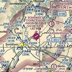
|
| Airport distance calculator |
|---|
|
|
| Sunrise and sunset |
|---|
|
Times for 15-Apr-2025
| | Local
(UTC-4) | | Zulu
(UTC) |
|---|
| Morning civil twilight | | 06:11 | | 10:11 |
| Sunrise | | 06:39 | | 10:39 |
| Sunset | | 19:53 | | 23:53 |
| Evening civil twilight | | 20:21 | | 00:21 |
|
| Current date and time |
|---|
| Zulu (UTC) | 15-Apr-2025 21:19:22 |
|---|
| Local (UTC-4) | 15-Apr-2025 17:19:22 |
|---|
|
| METAR |
|---|
| K2G9 | 152055Z AUTO 28019G28KT 10SM DZ SCT013 BKN022 OVC034 03/01 A2970 RMK AO2
|
KJST
19nm NE | 152054Z AUTO 26015G21KT 7SM -RA BKN012 OVC021 04/02 A2966 RMK AO2 PK WND 28037/2012 RAB06 SLP051 P0002 60003 T00390017 53024
|
|
| TAF |
|---|
KJST
19nm NE | 152005Z 1520/1618 28022G35KT P6SM -SHRA SCT025 BKN040 FM152300 28018G34KT P6SM -SHRA OVC025 FM160300 28020G34KT P6SM -SNRA BKN018 FM160700 29020G27KT P6SM -SHSN OVC007 FM160800 28019G26KT P6SM OVC015 FM161600 29020G29KT P6SM BKN050 OVC070
|
KLBE
22nm NW | 151729Z 1518/1618 27025G35KT 6SM -SHRA BKN045 PROB30 1518/1521 27025G45KT 5SM -TSRAGS BR BKN030CB FM152200 26020G30KT 6SM -SHRA OVC025 PROB30 1608/1612 4SM -SHRASN BR BKN015 FM161600 27019G25KT P6SM BKN050
|
|
| NOTAMs |
|---|
NOTAMs are issued by the DoD/FAA and will open in a separate window not controlled by AirNav.
|
|


