FAA INFORMATION EFFECTIVE 20 MARCH 2025
Location
| FAA Identifier: | DYL |
| Lat/Long: | 40-19-58.9810N 075-07-20.4180W
40-19.983017N 075-07.340300W
40.3330503,-75.1223383
(estimated) |
| Elevation: | 393.7 ft. / 120.0 m (surveyed) |
| Variation: | 12W (1995) |
| From city: | 2 miles N of DOYLESTOWN, PA |
| Time zone: | UTC -4 (UTC -5 during Standard Time) |
| Zip code: | 18901 |
Airport Operations
| Airport use: | Open to the public |
| Activation date: | 05/1942 |
| Control tower: | no |
| ARTCC: | NEW YORK CENTER |
| FSS: | WILLIAMSPORT FLIGHT SERVICE STATION |
| NOTAMs facility: | DYL (NOTAM-D service available) |
| Attendance: | 0700-DUSK
NO SERVICES AVBL CHRISTMAS, NEW YEARS, & THANKSGIVING. |
| Wind indicator: | lighted |
| Segmented circle: | yes |
| Lights: | ACTVT REIL 23; MIRL 05/23 - CTAF. MIRL 05/23 OPR CONSLY-SS-SR. |
| Beacon: | white-green (lighted land airport)
Operates sunset to sunrise. |
Airport Communications
| CTAF/UNICOM: | 122.975 |
| WX ASOS: | 118.875 (215-345-0392) |
| PHILADELPHIA APPROACH: | 123.8 |
| PHILADELPHIA DEPARTURE: | 123.8 |
| CLEARANCE DELIVERY: | 118.55 |
| WX AWOS-3 at CKZ (8 nm NW): | 126.325 (215-257-7291) |
| WX AWOS-3 at UKT (13 nm NW): | 119.475 (215-538-7610) |
| WX AWOS-3 at LOM (13 nm SW): | 118.925 (215-646-1068) |
| WX ASOS at TTN (15 nm E): | 126.775 (609-538-8690) |
| WX AWOS-3 at N40 (15 nm NE): | 121.725 |
| WX ASOS at PNE (16 nm S): | PHONE 215-897-9068 |
- CLEARANCE DELIVERY PHILADELPHIA APCH TF 800-354-9884.
Nearby radio navigation aids
| VOR radial/distance | | VOR name | | Freq | | Var |
|---|
| ARDr306/10.9 | | YARDLEY VOR/DME | | 108.20 | | 10W |
| PTWr081/21.1 | | POTTSTOWN VORTAC | | 116.50 | | 09W |
| SBJr239/23.0 | | SOLBERG VOR/DME | | 112.90 | | 10W |
| FJCr157/28.1 | | ALLENTOWN VORTAC | | 117.50 | | 10W |
| ETXr129/29.6 | | EAST TEXAS VOR/DME | | 110.20 | | 09W |
| RBVr295/29.8 | | ROBBINSVILLE VORTAC | | 113.80 | | 10W |
| GXUr321/31.0 | | MC GUIRE VORTAC | | 110.60 | | 12W |
| BWZr217/31.1 | | BROADWAY VOR/DME | | 114.20 | | 11W |
| MXEr054/35.4 | | MODENA VORTAC | | 113.20 | | 09W |
| NDB name | | Hdg/Dist | | Freq | | Var | | ID |
|---|
| LAKEHURST | | 307/40.0 | | 396 | | 11W | | NEL | -. . .-.. |
Airport Services
| Fuel available: | 100LL JET-A |
| Parking: | tiedowns |
| Airframe service: | MAJOR |
| Powerplant service: | MAJOR |
| Bottled oxygen: | NONE |
| Bulk oxygen: | LOW |
Runway Information
Runway 5/23
| Dimensions: | 3002 x 60 ft. / 915 x 18 m |
| Surface: | asphalt, in good condition |
| Weight bearing capacity: | |
| Runway edge lights: | medium intensity |
| RUNWAY 5 | | RUNWAY 23 |
| Latitude: | 40-19.787617N | | 40-20.180290N |
| Longitude: | 075-07.536205W | | 075-07.143720W |
| Elevation: | 391.7 ft. | | 393.7 ft. |
| Traffic pattern: | left | | left |
| Runway heading: | 049 magnetic, 037 true | | 229 magnetic, 217 true |
| Markings: | nonprecision, in good condition | | nonprecision, in good condition |
| Visual slope indicator: | 2-box SAVASI on left (5.00 degrees glide path) | | 2-light PAPI on left (3.00 degrees glide path) |
| Runway end identifier lights: | | | yes |
| Touchdown point: | yes, no lights | | yes, no lights |
| Obstructions: | 39 ft. trees, 772 ft. from runway, 281 ft. right of centerline, 14:1 slope to clear | | 64 ft. trees, 1162 ft. from runway, 355 ft. left of centerline, 15:1 slope to clear |
Airport Ownership and Management from official FAA records
| Ownership: | Publicly-owned |
| Owner: | BUCKS COUNTY AIRPORT AUTH
BOX 1185
DOYLESTOWN, PA 18902
Phone 215-345-1970 |
| Manager: | MARCEL BISSCHOPS
3879 OLD EASTON RD
DOYLESTOWN, PA 18902
Phone 215-340-0707 |
Additional Remarks
| - | NOISE ABATEMENT PROCEDURES IN EFFECT; CTC AMGR 215-340-0707. |
| - | DEER, GEESE AND OTHER WILDLIFE ON AND INVOF RWY. |
| - | RY 05 IS USED FOR CROSSWIND & CALM WIND RY. |
| - | FOR CD CTC PHILADELPHIA APCH AT 800-354-9884. |
Instrument Procedures
NOTE: All procedures below are presented as PDF files. If you need a reader for these files, you should download the free Adobe Reader.NOT FOR NAVIGATION. Please procure official charts for flight.
FAA instrument procedures published for use from 20 March 2025 at 0901Z to 17 April 2025 at 0900z.
IAPs - Instrument Approach Procedures |
|---|
| RNAV (GPS) RWY 05 | |
download (184KB) |
| RNAV (GPS) RWY 23 | |
download (184KB) |
| VOR-A | |
download (192KB) |
| NOTE: Special Alternate Minimums apply | |
download (132KB) |
| NOTE: Special Take-Off Minimums/Departure Procedures apply | |
download (149KB) |
Other nearby airports with instrument procedures:
KCKZ - Pennridge Airport (8 nm NW)
KUKT - Quakertown Airport (13 nm NW)
KLOM - Wings Field Airport (13 nm SW)
KTTN - Trenton Mercer Airport (15 nm E)
N40 - Sky Manor Airport (15 nm NE)
KPNE - Northeast Philadelphia Airport (16 nm S)
N85 - Alexandria Airport (16 nm N)
|
|

Road maps at:
MapQuest
Bing
Google
| Aerial photo |
|---|
WARNING: Photo may not be current or correct
 Photo by Sajeeb Baksh
Photo taken 04-Jul-2019
looking west.
Photo by Sajeeb Baksh
Photo taken 04-Jul-2019
looking west.
Do you have a better or more recent aerial photo of Doylestown Airport that you would like to share? If so, please send us your photo.
|
| Sectional chart |
|---|
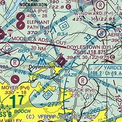
|
| Airport distance calculator |
|---|
|
|
| Sunrise and sunset |
|---|
|
Times for 13-Apr-2025
| | Local
(UTC-4) | | Zulu
(UTC) |
|---|
| Morning civil twilight | | 05:58 | | 09:58 |
| Sunrise | | 06:26 | | 10:26 |
| Sunset | | 19:36 | | 23:36 |
| Evening civil twilight | | 20:04 | | 00:04 |
|
| Current date and time |
|---|
| Zulu (UTC) | 13-Apr-2025 11:38:55 |
|---|
| Local (UTC-4) | 13-Apr-2025 07:38:55 |
|---|
|
| METAR |
|---|
| KDYL | 131054Z AUTO 00000KT 10SM OVC026 07/03 A2993 RMK AO2 SLP137 T00720033 $
|
KCKZ
8nm NW | 131115Z AUTO 34006KT 10SM OVC026 06/05 A2994 RMK AO2
|
KUKT
13nm NW | 131115Z AUTO 33005KT 10SM OVC026 07/04 A2994 RMK AO2
|
KLOM
13nm SW | 131115Z AUTO 30003KT 10SM OVC027 06/04 A2995 RMK AO2 T00640039
|
KTTN
14nm E | ASOS 133.70 609-538-8690
131121Z 00000KT 10SM BKN025 OVC042 04/03 A2993 RMK AO2 T00440028
|
KPNE
16nm S | 131054Z 33004KT 10SM BKN034 OVC045 07/03 A2995 RMK AO2 SLP142 T00670033 $
|
|
| TAF |
|---|
KTTN
14nm E | 130954Z 1310/1406 35006KT P6SM OVC035 TEMPO 1310/1312 BKN030 FM131200 34006G12KT P6SM BKN035 FM131600 33010G20KT P6SM BKN040 FM140000 VRB04KT P6SM FEW200
|
KPNE
16nm S | 130954Z 1310/1406 34005KT P6SM OVC035 TEMPO 1310/1312 BKN030 FM131600 33010G20KT P6SM BKN040 FM140000 VRB04KT P6SM FEW200
|
|
| NOTAMs |
|---|
NOTAMs are issued by the DoD/FAA and will open in a separate window not controlled by AirNav.
|
|


