FAA INFORMATION EFFECTIVE 14 MAY 2026
Location
| FAA Identifier: | TTN |
| Lat/Long: | 40-16-36.1000N 074-48-48.5000W
40-16.601667N 074-48.808333W
40.2766944,-74.8134722
(estimated) |
| Elevation: | 212.6 ft. / 64.8 m (surveyed) |
| Variation: | 12W (1985) |
| From city: | 4 miles NW of TRENTON, NJ |
| Time zone: | UTC -4 (UTC -5 during Standard Time) |
| Zip code: | 08628 |
Airport Operations
| Airport use: | Open to the public |
| Activation date: | 03/1943 |
| Control tower: | yes |
| ARTCC: | NEW YORK CENTER |
| FSS: | MILLVILLE FLIGHT SERVICE STATION |
| NOTAMs facility: | TTN (NOTAM-D service available) |
| Attendance: | CONTINUOUS |
| Pattern altitude: | TPA FOR ACFT UNDER 12500 LBS 1200 FT MSL; ACFT 12500 LBS & OVER 1700 FT MSL. |
| Wind indicator: | lighted |
| Segmented circle: | no |
| Lights: | WHEN ATCT CLSD ACTVT HIRL RY 06/24; HIRL RY 16/34; MALSR RY 06; PAPI RYS 24; 16; 34; REIL RYS 24; 16; 34 & TWY LGTS - CTAF. |
| Beacon: | white-green (lighted land airport)
Operates sunset to sunrise. |
| Landing fee: | yes, LDG FEE FOR ALL TRANSIENT ACFT. |
| Fire and rescue: | ARFF index B |
| International operations: | US CUSTOMS USER FEE ARPT. |
Airport Communications
| CTAF: | 120.7 |
| UNICOM: | 122.95 |
| ATIS: | 126.775 |
| WX ASOS: | 126.775 (609-538-8690) |
| TRENTON GROUND: | 121.9 257.8 [0600-2200] |
| TRENTON TOWER: | 120.7 257.8 [0600-2200] |
| PHILADELPHIA APPROACH: | 123.8 |
| PHILADELPHIA DEPARTURE: | 123.8 |
| CLEARANCE DELIVERY: | 121.9 257.8 |
| ARNG OPS: | 46.725 |
| EMERG: | 121.5 243.0 |
| NG OPS: | 121.95 242.4 |
| WX ASOS at DYL (15 nm W): | 118.875 (215-345-0392) |
| WX ASOS at PNE (15 nm SW): | PHONE 215-897-9068 |
| WX AWOS-3 at N40 (19 nm NW): | 121.725 |
Nearby radio navigation aids
| VOR radial/distance | | VOR name | | Freq | | Var |
|---|
| ARDr082/4.5 | | YARDLEY VOR/DME | | 108.20 | | 10W |
| RBVr297/15.3 | | ROBBINSVILLE VORTAC | | 113.80 | | 10W |
| SBJr200/18.7 | | SOLBERG VOR/DME | | 112.90 | | 10W |
| GXUr340/18.9 | | MC GUIRE VORTAC | | 110.60 | | 12W |
| COLr277/30.0 | | COLTS NECK VOR/DME | | 115.40 | | 11W |
| BWZr190/31.3 | | BROADWAY VOR/DME | | 114.20 | | 11W |
| CYNr338/32.7 | | COYLE VORTAC | | 113.40 | | 10W |
| PTWr094/34.4 | | POTTSTOWN VORTAC | | 116.50 | | 09W |
| FJCr143/39.8 | | ALLENTOWN VORTAC | | 117.50 | | 10W |
| NDB name | | Hdg/Dist | | Freq | | Var | | ID |
|---|
| LAKEHURST | | 313/26.0 | | 396 | | 11W | | NEL | -. . .-.. |
Airport Services
| Fuel available: | 100LL JET-A JET-A+
100LL:FUEL AVBL ON 24/7. |
| Parking: | hangars and tiedowns |
| Airframe service: | MAJOR |
| Powerplant service: | MAJOR |
| Bottled oxygen: | LOW |
| Bulk oxygen: | LOW |
Runway Information
Runway 6/24
| Dimensions: | 6006 x 150 ft. / 1831 x 46 m |
| Surface: | asphalt/grooved, in good condition |
| Weight bearing capacity: | | Single wheel: | 120.0 | | Double wheel: | 180.0 | | Double tandem: | 320.0 |
|
| Runway edge lights: | high intensity |
| RUNWAY 6 | | RUNWAY 24 |
| Latitude: | 40-16.185155N | | 40-16.866338N |
| Longitude: | 074-49.294603W | | 074-48.358185W |
| Elevation: | 160.3 ft. | | 192.1 ft. |
| Traffic pattern: | left | | left |
| Runway heading: | 058 magnetic, 046 true | | 238 magnetic, 226 true |
| Declared distances: | TORA:6006 TODA:6006 ASDA:6006 LDA:6006 | | TORA:6006 TODA:6006 ASDA:6006 LDA:6006 |
| Markings: | precision, in good condition | | precision, in good condition |
| Visual slope indicator: | | | 4-light PAPI on left (3.00 degrees glide path) |
| Approach lights: | MALSR: 1,400 foot medium intensity approach lighting system with runway alignment indicator lights | | |
| Runway end identifier lights: | | | yes |
| Touchdown point: | yes, no lights | | yes, no lights |
| Instrument approach: | ILS | | |
| Obstructions: | 87 ft. tree, 2120 ft. from runway, 790 ft. right of centerline, 22:1 slope to clear
RWY 06, 185 FT LGTD POLE; 100 FT FROM THRESHOLD, 500 FT R. | | none |
Runway 16/34
| Dimensions: | 4800 x 150 ft. / 1463 x 46 m |
| Surface: | asphalt/grooved, in good condition |
| Weight bearing capacity: | | Single wheel: | 120.0 | | Double wheel: | 180.0 | | Double tandem: | 320.0 |
|
| Runway edge lights: | high intensity |
| RUNWAY 16 | | RUNWAY 34 |
| Latitude: | 40-17.022923N | | 40-16.370203N |
| Longitude: | 074-49.078337W | | 074-48.496013W |
| Elevation: | 212.6 ft. | | 174.4 ft. |
| Traffic pattern: | left | | left |
| Runway heading: | 158 magnetic, 146 true | | 338 magnetic, 326 true |
| Declared distances: | TORA:4800 TODA:4800 ASDA:4800 LDA:4800 | | TORA:4800 TODA:4800 ASDA:4800 LDA:4800 |
| Markings: | nonprecision, in good condition | | nonprecision, in good condition |
| Visual slope indicator: | 4-light PAPI on left (3.00 degrees glide path) | | 4-light PAPI on left (3.00 degrees glide path) |
| Runway end identifier lights: | yes | | yes |
| Touchdown point: | yes, no lights | | yes, no lights |
Helipad H1
| Dimensions: | 64 x 64 ft. / 20 x 20 m |
| Surface: | asphalt, in good condition |
| Operational restrictions: | LOCATED AT INTXN OF TWYS 'H' & 'H1'. |
| Latitude: | 40-16.934333N | | |
| Longitude: | 074-48.894500W | | |
| Elevation: | 204.0 ft. | | |
| Traffic pattern: | left | | left |
| Markings: | basic, in good condition | | |
Helipad H2
| Dimensions: | 64 x 64 ft. / 20 x 20 m |
| Surface: | asphalt, in good condition |
| Operational restrictions: | LCTD AT NORTHEAST END OF TWY 'B'. |
| Latitude: | 40-16.948833N | | |
| Longitude: | 074-48.390000W | | |
| Elevation: | 191.0 ft. | | |
| Traffic pattern: | left | | left |
| Markings: | basic, in good condition | | |
Helipad H3
| Dimensions: | 64 x 64 ft. / 20 x 20 m |
| Surface: | asphalt, in good condition |
| Latitude: | 40-16.273000N | | |
| Longitude: | 074-49.056000W | | |
| Elevation: | 169.5 ft. | | |
| Traffic pattern: | left | | left |
| Markings: | basic, in good condition | | |
Airport Ownership and Management from official FAA records
| Ownership: | Publicly-owned |
| Owner: | COUNTY OF MERCER
640 S BROAD ST
TRENTON, NJ 08650
Phone 609-989-6518 |
| Manager: | ERIC BILLOWITZ
340 SCOTCH ROAD, SUITE 200
EWING, NJ 08628
Phone 609-882-1601 |
Additional Remarks
| A39-06/24 | PCR VALUE: 590/F/B/X/T |
| A39-16/34 | PCR VALUE: 700/F/B/X/T |
| E60-34 | RY 34 ENGINEERED MATERIALS ARRESTING SYSTEM (EMAS), 226 FT LONG BY 162 FT WIDE, LCTD DER 34. |
| E60-24 | RY 24 ENGINEERED MATERIAL ARRESTING SYSTEM 251X162 DEP END. |
| E60-16 | RY 16, ENGINEERED MATERIALS ARRESTING SYSTEM (EMAS), 247 FT LONG BY 162 FT WIDE, LCTD DER 16. |
| E60-06 | RY 6 ENGINEERED MATERIAL ARRESTING SYSTEM 308X162 DEP END. |
| - | GEESE & FLOCKS OF SEA GULLS & DEER ON & INVOF ARPT. |
| - | NOISE ABATEMENT PROCS IN EFCT; DEPS OVER 12500 LBS FLY RY HEADING UNTIL 1700 FT MSL; DEPS UNDER 12500 LBS FLY RY HEADING UNTIL 1200 FT MSL. |
| - | NO TGL OR TRAINING OPNS 2200-0700. |
| - | FOR CD WHEN ATCT IS CLSD CTC PHL APCH AT (800) 354-9884. |
| - | VOLUNTARY CURFEW 0000-0600 LCL. |
| - | TWR VIEW OF TWY J OBSC CTN ADZ. |
| - | ARFF MNTS GND AND ATCT FREQS DURG ATC ZERO EVENTS. |
| - | TWY E CLSD TO ACFT WINGSPAN MORE THAN 110FT EXC 24HR PPR 609-883-0994. |
| - | TWY C CLSD TO ACFT MORE THAN 40000 LB. |
Instrument Procedures
NOTE: All procedures below are presented as PDF files. If you need a reader for these files, you should download the free Adobe Reader.NOT FOR NAVIGATION. Please procure official charts for flight.
FAA instrument procedures published for use from 14 May 2026 at 0901Z to 11 June 2026 at 0900Z.
STARs - Standard Terminal Arrivals |
|---|
| BUNTS THREE | |
download (154KB) |
| JIIMS FOUR (RNAV) | |
download (351KB) |
| PAATS FOUR (RNAV) | |
2 pages:
[1] [2] (488KB) |
IAPs - Instrument Approach Procedures |
|---|
| ILS OR LOC RWY 06 **CHANGED** | |
download (252KB) |
| RNAV (RNP) Y RWY 06 | |
download (223KB) |
| RNAV (RNP) Y RWY 24 | |
download (204KB) |
| RNAV (GPS) RWY 16 | |
download (313KB) |
| RNAV (GPS) RWY 34 | |
download (264KB) |
| RNAV (GPS) Z RWY 06 | |
download (290KB) |
| RNAV (GPS) Z RWY 24 | |
download (294KB) |
| VOR-A | |
download (229KB) |
| NOTE: Special Alternate Minimums apply **CHANGED** | |
download (164KB) |
| NOTE: Special Take-Off Minimums/Departure Procedures apply | |
download (150KB) |
Other nearby airports with instrument procedures:
39N - Princeton Airport (10 nm NE)
N87 - Trenton-Robbinsville Airport (10 nm E)
KDYL - Doylestown Airport (15 nm W)
KPNE - Northeast Philadelphia Airport (15 nm SW)
47N - Central Jersey Regional Airport (18 nm NE)
KWRI - McGuire Field (Joint Base Mc Guire Dix Lakehurst) Airport (19 nm SE)
N51 - Solberg/Hunterdon Airport (19 nm N)
N40 - Sky Manor Airport (19 nm NW)
|
|

Road maps at:
MapQuest
Bing
Google
| Aerial photo |
|---|
WARNING: Photo may not be current or correct
 Photo courtesy of AirNav, LLC
Photo taken 14-May-2013
looking south.
Photo courtesy of AirNav, LLC
Photo taken 14-May-2013
looking south.
Do you have a better or more recent aerial photo of Trenton Mercer Airport that you would like to share? If so, please send us your photo.
|
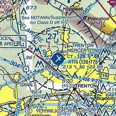
| Sectional chart |
|---|
|
CAUTION: Diagram may not be current
 Download PDF
of official airport diagram from the FAA
| Airport distance calculator |
|---|
|
|
| Sunrise and sunset |
|---|
|
Times for 21-May-2026
| | Local
(UTC-4) | | Zulu
(UTC) |
|---|
| Morning civil twilight | | 05:08 | | 09:08 |
| Sunrise | | 05:39 | | 09:39 |
| Sunset | | 20:13 | | 00:13 |
| Evening civil twilight | | 20:44 | | 00:44 |
|
| Current date and time |
|---|
| Zulu (UTC) | 21-May-2026 04:04:29 |
|---|
| Local (UTC-4) | 21-May-2026 00:04:29 |
|---|
|
| METAR |
|---|
| KTTN | ASOS 133.70 609-538-8690
210353Z AUTO 33007KT 10SM CLR 18/17 A3006 RMK AO2 SLP173 T01830167
|
KDYL
14nm W | 210354Z AUTO 01004KT 10SM FEW009 18/17 A3008 RMK AO2 SLP181 T01830172
|
KPNE
15nm SW | 210354Z 35005KT 10SM 21/19 A3008 RMK AO2 SLP184 T02110194 $
|
KWRI
19nm SE | 210255Z 33005KT 10SM CLR 21/20 A3004 RMK AO2A SLP171 P0000 60004 T02130201 53003 $
|
|
| TAF |
|---|
| KTTN | 202237Z 2023/2118 30012KT 6SM -SHRA BR VCTS SCT030CB OVC050 FM210000 33010KT 6SM -SHRA SCT035 BKN070 FM210200 36005KT P6SM SCT025 OVC035 FM211300 03010KT 6SM -SHRA BR OVC025
|
KPNE
15nm SW | 202228Z 2022/2118 30012G20KT 6SM -SHRA BR VCTS SCT020CB OVC050 FM202300 33012KT 6SM -SHRA SCT035 BKN070 FM210200 01005KT P6SM SCT025 OVC035 FM211300 04012KT 6SM -SHRA BR OVC025
|
KWRI
19nm SE | 210200Z 2102/2208 32010G15KT 8000 -SHRA BKN010 BKN030 QNH3002INS TEMPO 2106/2108 -RA VCTS BKN020CB BKN040 BECMG 2110/2111 01010G15KT 8000 -SHRA BKN020 BKN060 QNH3012INS BECMG 2112/2113 03012G18KT 9999 -SHRA BKN035 OVC040 QNH3016INS BECMG 2119/2120 08010KT 9999 NSW BKN020 OVC050 QNH3022INS TX20/2105Z TN14/2201Z
|
|
| NOTAMs |
|---|
NOTAMs are issued by the DoD/FAA and will open in a separate window not controlled by AirNav.
|
|


