FAA INFORMATION EFFECTIVE 19 FEBRUARY 2026
Location
| FAA Identifier: | N51 |
| Lat/Long: | 40-34-58.0340N 074-44-12.1440W
40-34.967233N 074-44.202400W
40.5827872,-74.7367067
(estimated) |
| Elevation: | 189.6 ft. / 58 m (estimated) |
| Variation: | 10W (1965) |
| From city: | 1 mile NW of READINGTON, NJ |
| Time zone: | UTC -5 (UTC -4 during Daylight Saving Time) |
| Zip code: | 08889 |
Airport Operations
| Airport use: | Open to the public |
| Activation date: | 03/1942 |
| Control tower: | no |
| ARTCC: | NEW YORK CENTER |
| FSS: | MILLVILLE FLIGHT SERVICE STATION |
| NOTAMs facility: | MIV (NOTAM-D service available) |
| Attendance: | 0900-1700
ARPT UNATNDD ALL MAJOR HOLIDAYS & CHRISTMAS & NEW YEARS EVE AFTERNOONS. |
| Wind indicator: | yes |
| Segmented circle: | no |
| Lights: | ACTVT REIL RWY 04 & 22; MIRL RWY 04/22 - CTAF. PAPI RWY 04 & 22 OPR CONSLY. |
Airport Communications
| CTAF/UNICOM: | 122.8 |
| NEWARK APPROACH: | 132.8 |
| NEWARK DEPARTURE: | 132.8 |
| WILKES-BARRE STAR: | 127.6 |
| WX ASOS at SMQ (4 nm NE): | 120.6 (908-722-2139) |
| WX AWOS-3 at N40 (11 nm W): | 121.725 |
| WX ASOS at TTN (19 nm S): | 126.775 (609-538-8690) |
| WX AWOS-3 at MMU (20 nm NE): | PHONE 973-290-0135 |
Nearby radio navigation aids
| VOR radial/distance | | VOR name | | Freq | | Var |
|---|
| SBJ at field | | SOLBERG VOR/DME | | 112.90 | | 10W |
| BWZr174/13.5 | | BROADWAY VOR/DME | | 114.20 | | 11W |
| ARDr032/21.3 | | YARDLEY VOR/DME | | 108.20 | | 10W |
| RBVr344/25.4 | | ROBBINSVILLE VORTAC | | 113.80 | | 10W |
| STWr177/25.5 | | STILLWATER VOR/DME | | 109.60 | | 11W |
| SAXr208/30.4 | | SPARTA VORTAC | | 115.70 | | 11W |
| COLr313/31.0 | | COLTS NECK VOR/DME | | 115.40 | | 11W |
| FJCr115/33.8 | | ALLENTOWN VORTAC | | 117.50 | | 10W |
| TEBr254/34.6 | | TETERBORO VOR/DME | | 108.40 | | 11W |
| GXUr001/35.0 | | MC GUIRE VORTAC | | 110.60 | | 12W |
| CRIr278/38.4 | | CANARSIE VOR/DME | | 112.30 | | 11W |
| NDB name | | Hdg/Dist | | Freq | | Var | | ID |
|---|
| LAKEHURST | | 341/37.1 | | 396 | | 11W | | NEL | -. . .-.. |
Airport Services
| Fuel available: | 100LL JET-A |
| Parking: | hangars and tiedowns |
| Airframe service: | MAJOR |
| Powerplant service: | MAJOR |
| Bottled oxygen: | NONE |
| Bulk oxygen: | LOW |
Runway Information
Runway 4/22
| Dimensions: | 5598 x 50 ft. / 1706 x 15 m |
| Surface: | asphalt/turf
RWY 04 TURF PORTION POOR AND UNUSBL. CENTER ASPH PORTION EXCELLENT. RWY 22 TURF PORTION POOR AND UNUSBL.
RWY 04 & RWY 22 TURF PTN POOR. |
| Runway edge lights: | medium intensity
RWY 04/22 MIRL ON PAVED 3735 FT BY 50 FT PORTION OF RWY. |
| RUNWAY 4 | | RUNWAY 22 |
| Latitude: | 40-34.445950N | | 40-35.248450N |
| Longitude: | 074-44.428000W | | 074-43.832783W |
| Elevation: | 179.8 ft. | | 153.0 ft. |
| Traffic pattern: | left | | left |
| Runway heading: | 039 magnetic, 029 true | | 219 magnetic, 209 true |
| Displaced threshold: | 544 ft.
DSPLCD THLD 544 FT TURF 180 FT WIDE. | | 1319 ft.
DSPLCD THLD 1319 FT TURF 180 FT WIDE. |
| Markings: | basic, in good condition | | nonprecision, in good condition |
| Visual slope indicator: | 2-light PAPI on left (3.00 degrees glide path) | | 2-light PAPI on left (3.00 degrees glide path) |
| Runway end identifier lights: | yes | | yes |
| Touchdown point: | yes, no lights | | yes, no lights |
| Obstructions: | none | | 66 ft. tree, 1655 ft. from runway, 150 ft. right of centerline, 22:1 slope to clear |
Runway 13/31
| Dimensions: | 3444 x 200 ft. / 1050 x 61 m |
| Surface: | turf, in good condition |
| RUNWAY 13 | | RUNWAY 31 |
| Latitude: | 40-35.319667N | | 40-35.040500N |
| Longitude: | 074-44.533667W | | 074-43.886167W |
| Elevation: | 186.9 ft. | | 152.1 ft. |
| Traffic pattern: | left | | left |
| Runway heading: | 129 magnetic, 119 true | | 309 magnetic, 299 true |
| Markings: | , in good condition | | , in good condition |
| Touchdown point: | yes, no lights | | yes, no lights |
| Obstructions: | 40 ft. tree, 108 ft. from runway, 99 ft. left of centerline, 2:1 slope to clear | | 44 ft. trees, 48 ft. from runway, 1:1 slope to clear |
Runway 10/28
| Dimensions: | 2010 x 100 ft. / 613 x 30 m |
| Surface: | turf, in fair condition
NOTICEABLE BUMP WHERE RWY CROSSES GRVL APCH ROAD TO VORTAC. |
| RUNWAY 10 | | RUNWAY 28 |
| Latitude: | 40-34.910538N | | 40-34.963167N |
| Longitude: | 074-44.604360W | | 074-44.175667W |
| Elevation: | 186.2 ft. | | 178.0 ft. |
| Traffic pattern: | left | | left |
| Runway heading: | 091 magnetic, 081 true | | 271 magnetic, 261 true |
| Markings: | , in poor condition | | , in poor condition |
| Touchdown point: | yes, no lights | | yes, no lights |
| Obstructions: | 58 ft. trees, marked, 602 ft. from runway, 81 ft. right of centerline, 6:1 slope to clear | | none |
Airport Ownership and Management from official FAA records
| Ownership: | Privately-owned |
| Owner: | SOLBERG AVIATION COMPANY
39 THOR SOLBERG ROAD
WHITEHOUSE STATION, NJ 08889
Phone 908-534-4000 |
| Manager: | SUZANNE SOLBERG NAGLE
39 THOR SOLBERG ROAD
WHITEHOUSE STATION, NJ 08889
Phone 908-534-4000
CO-MGRS THOR SOLBERG III AND LORRAINE SOLBERG. |
Additional Remarks
| - | HEL FLY FIXED WING TFC PAT AND ALT. |
| - | NO INTXN TKOF ON RWY 04/22. |
| - | NO TGL ALL RWYS. |
| - | ALL RWYS DEPT STRAIGHT OUT TO 1200 FT MSL BEFORE TURNING. |
| - | BLIMP AND HOT AIR BALLOON ACTIVITY ON AND INVOF ARPT SPRING THRU FALL. |
| - | GCO AVBL ON FREQ 121.725. IF UNABLE, CTC NEWARK APCH AT 800-645-3206. |
| - | DEER ON AND INVOF ARPT. |
| - | TKOFS & LNDGS PROHIBITED ON RWY 13/31 & RWY 10/28 WHEN ACFT ARE OPERNG ON RWY 4/22. |
| - | CTC OPS, 908-534-4000, PRIOR TO OPERATING ON RWY 10/28. |
Instrument Procedures
NOTE: All procedures below are presented as PDF files. If you need a reader for these files, you should download the free Adobe Reader.NOT FOR NAVIGATION. Please procure official charts for flight.
FAA instrument procedures published for use from 19 February 2026 at 0901Z to 19 March 2026 at 0900Z.
STARs - Standard Terminal Arrivals |
|---|
| WILKES-BARRE FIVE | |
download (182KB) |
IAPs - Instrument Approach Procedures |
|---|
| RNAV (GPS) RWY 04 | |
download (203KB) |
| RNAV (GPS) RWY 22 | |
download (213KB) |
| VOR RWY 04 | |
download (232KB) |
| NOTE: Special Take-Off Minimums/Departure Procedures apply | |
download (454KB) |
Other nearby airports with instrument procedures:
KSMQ - Somerset Airport (4 nm NE)
47N - Central Jersey Regional Airport (7 nm SE)
N40 - Sky Manor Airport (11 nm W)
39N - Princeton Airport (12 nm S)
N85 - Alexandria Airport (13 nm W)
KTTN - Trenton Mercer Airport (19 nm S)
KMMU - Morristown Municipal Airport (20 nm NE)
|
|

Road maps at:
MapQuest
Bing
Google
| Aerial photo |
|---|
WARNING: Photo may not be current or correct
 Photo taken 04-Jun-2013
looking south.
Photo taken 04-Jun-2013
looking south.
Do you have a better or more recent aerial photo of Solberg/Hunterdon Airport that you would like to share? If so, please send us your photo.
|
| Sectional chart |
|---|
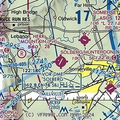
|
| Airport distance calculator |
|---|
|
|
| Sunrise and sunset |
|---|
|
Times for 19-Mar-2026
| | Local
(UTC-4) | | Zulu
(UTC) |
|---|
| Morning civil twilight | | 06:38 | | 10:38 |
| Sunrise | | 07:05 | | 11:05 |
| Sunset | | 19:09 | | 23:09 |
| Evening civil twilight | | 19:36 | | 23:36 |
|
| Current date and time |
|---|
| Zulu (UTC) | 19-Mar-2026 07:49:43 |
|---|
| Local (UTC-4) | 19-Mar-2026 03:49:43 |
|---|
|
| METAR |
|---|
KSMQ
4nm NE | ASOS 120.60 908-722-2139
190653Z AUTO 00000KT 10SM FEW095 FEW120 M01/M07 A3032 RMK AO2 SLP269 T10111072
|
KTTN
18nm S | ASOS 133.70 609-538-8690
190653Z AUTO 17005KT 10SM BKN080 OVC110 M01/M07 A3032 RMK AO2 SLP264 T10111072
|
KMMU
19nm NE | 190715Z AUTO 00000KT 10SM SCT120 M01/M07 A3033 RMK AO2
|
|
| TAF |
|---|
KTTN
18nm S | 190538Z 1906/2006 15004KT P6SM OVC080 FM191400 19006KT P6SM BKN060 FM191800 22008KT P6SM BKN050 FM192300 21004KT P6SM BKN040
|
|
| NOTAMs |
|---|
NOTAMs are issued by the DoD/FAA and will open in a separate window not controlled by AirNav.
|
|

