FAA INFORMATION EFFECTIVE 17 APRIL 2025
Location
| FAA Identifier: | GEO |
| Lat/Long: | 38-52-55.0041N 083-52-57.8520W
38-52.916735N 083-52.964200W
38.8819456,-83.8827367
(estimated) |
| Elevation: | 957.6 ft. / 291.9 m (surveyed) |
| Variation: | 05W (2000) |
| From city: | 1 mile NE of GEORGETOWN, OH |
| Time zone: | UTC -4 (UTC -5 during Standard Time) |
| Zip code: | 45121 |
Airport Operations
| Airport use: | Open to the public |
| Activation date: | 04/1971 |
| Control tower: | no |
| ARTCC: | INDIANAPOLIS CENTER |
| FSS: | DAYTON FLIGHT SERVICE STATION |
| NOTAMs facility: | DAY (NOTAM-D service available) |
| Attendance: | UNATNDD |
| Wind indicator: | lighted |
| Segmented circle: | no |
| Lights: | ACTVT REIL RWY 18 & 36; MIRL RWY 18/36 - CTAF. |
| Beacon: | white-green (lighted land airport)
Operates sunset to sunrise. |
Airport Communications
| CTAF: | 122.9 |
| WX AWOS-3 at I69 (19 nm NW): | 127.275 (513-732-6978) |
- APCH/DEP SVC PRVDD BY INDIANAPOLIS ARTCC ON FREQS 135.575/290.5 (MERWYN RCAG).
Nearby radio navigation aids
| VOR radial/distance | | VOR name | | Freq | | Var |
|---|
| FLMr059/24.4 | | FALMOUTH VOR/DME | | 117.00 | | 04W |
| MXQr191/33.1 | | MIDWEST VOR/DME | | 112.90 | | 04W |
| CVGr106/39.1 | | CINCINNATI VORTAC | | 117.30 | | 04W |
| NDB name | | Hdg/Dist | | Freq | | Var | | ID |
|---|
| SPORTYS | | 131/19.4 | | 245 | | 04W | | PWF | .--. .-- ..-. |
Airport Services
| Fuel available: | 100LL UL94
100LL:SELF SERVICE FUEL AVBL 24 HRS WITH CREDIT CARD. |
| Parking: | hangars and tiedowns |
| Airframe service: | FOR AIRFRAME & POWERPLANT REPAIRS PHONE 937-379-1055. |
| Bottled oxygen: | NONE |
| Bulk oxygen: | NONE |
Runway Information
Runway 18/36
| Dimensions: | 3530 x 65 ft. / 1076 x 20 m |
| Surface: | asphalt, in fair condition |
| Runway edge lights: | medium intensity |
| RUNWAY 18 | | RUNWAY 36 |
| Latitude: | 38-53.203233N | | 38-52.630235N |
| Longitude: | 083-53.027545W | | 083-52.900865W |
| Elevation: | 955.6 ft. | | 953.3 ft. |
| Traffic pattern: | left | | left |
| Runway heading: | 175 magnetic, 170 true | | 355 magnetic, 350 true |
| Markings: | nonprecision, in fair condition | | nonprecision, in fair condition |
| Visual slope indicator: | 4-light PAPI on left (3.03 degrees glide path) | | 4-light PAPI on left (3.03 degrees glide path) |
| Runway end identifier lights: | yes | | yes |
| Touchdown point: | yes, no lights | | yes, no lights |
| Obstructions: | 100 ft. trees, 854 ft. from runway, 186 ft. right of centerline, 6:1 slope to clear
ALSO 10 FT ROAD, 300 FT FM, 0 B, APCH RATIO 10:1. | | 40 ft. tree, 438 ft. from runway, 245 ft. right of centerline, 5:1 slope to clear |
Airport Ownership and Management from official FAA records
| Ownership: | Publicly-owned |
| Owner: | BROWN CO COMM
BROWN COUNTY COURTHOUSE
GEORGETOWN, OH 45121
Phone 937-378-3956 |
| Manager: | STEVE AND SANDY MCKINNEY
8862 AIRPORT ROAD
GEORGETOWN, OH 45121
Phone 937-483-6212
ADNL CTC: HOME 937-379-1634; BUS 937-379-1055. SPMCKINNEY53@GMAIL.COM |
Additional Remarks
| - | FOR CD CTC INDIANAPOLIS ARTCC AT 317-247-2411. |
Instrument Procedures
NOTE: All procedures below are presented as PDF files. If you need a reader for these files, you should download the free Adobe Reader.NOT FOR NAVIGATION. Please procure official charts for flight.
FAA instrument procedures published for use from 17 April 2025 at 0901Z to 15 May 2025 at 0900z.
IAPs - Instrument Approach Procedures |
|---|
| RNAV (GPS) RWY 36 | |
download (195KB) |
| VOR/DME-A | |
download (181KB) |
| NOTE: Special Take-Off Minimums/Departure Procedures apply | |
download (164KB) |
Other nearby airports with instrument procedures:
KAMT - Alexander Salamon Airport (15 nm E)
I69 - Clermont County Airport (19 nm NW)
KFGX - Fleming-Mason Airport (21 nm S)
KHOC - Highland County Airport (24 nm NE)
K62 - Gene Snyder Airport (26 nm SW)
|
|

Road maps at:
MapQuest
Bing
Google
| Aerial photo |
|---|
WARNING: Photo may not be current or correct

Do you have a better or more recent aerial photo of Brown County Airport that you would like to share? If so, please send us your photo.
|
| Sectional chart |
|---|
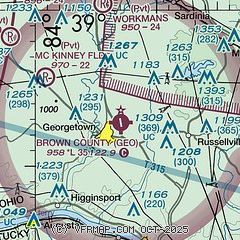
|
| Airport distance calculator |
|---|
|
|
| Sunrise and sunset |
|---|
|
Times for 14-May-2025
| | Local
(UTC-4) | | Zulu
(UTC) |
|---|
| Morning civil twilight | | 05:55 | | 09:55 |
| Sunrise | | 06:25 | | 10:25 |
| Sunset | | 20:39 | | 00:39 |
| Evening civil twilight | | 21:09 | | 01:09 |
|
| Current date and time |
|---|
| Zulu (UTC) | 15-May-2025 00:40:15 |
|---|
| Local (UTC-4) | 14-May-2025 20:40:15 |
|---|
|
| METAR |
|---|
KI69
19nm NW | 150016Z AUTO 14004KT 10SM SCT120 22/18 A2979 RMK AO1 T02200180
|
KFGX
21nm S | 150015Z AUTO 17004KT 10SM CLR 22/16 A2981 RMK AO2 T02150156
|
KK62
26nm SW | 150015Z AUTO 13003KT 10SM SCT042 SCT050 22/16 A2978 RMK AO2
|
KLUK
28nm NW | 142353Z 13004KT 10SM CLR 24/18 A2976 RMK AO2 SLP074 60002 T02390183 10256 20194 58006
|
KILN
33nm N | 142354Z AUTO 14004KT 10SM BKN100 OVC120 21/17 A2979 RMK AO2 SLP085 60000 T02060172 10217 20189 58008
|
KCVG
38nm W | 142352Z 17009KT 10SM FEW040 23/17 A2976 RMK AO2 SLP069 T02280167 10244 20194 58005 VISNO 36R $
|
|
| TAF |
|---|
KLUK
28nm NW | 141721Z 1418/1518 18005KT 5SM -SHRA SCT012 BKN040 FM142000 18005KT P6SM SCT040 PROB30 1420/1423 5SM -TSRA BKN040CB FM142300 14004KT P6SM SCT080 FM150400 00000KT 4SM BR SCT080 FM150600 00000KT 4SM BR SCT060 PROB30 1506/1510 -TSRA BKN060CB FM151000 00000KT 2SM BR SCT060 FM151400 18007KT P6SM SCT040
|
KILN
33nm N | 141721Z 1418/1518 20005KT P6SM -SHRA SCT020 BKN040 TEMPO 1418/1421 3SM -TSRA BKN020CB FM142100 18005KT P6SM BKN040 PROB30 1421/1423 -TSRA BKN040CB FM142300 16004KT P6SM BKN080 FM151400 18010KT P6SM SCT040
|
|
| NOTAMs |
|---|
NOTAMs are issued by the DoD/FAA and will open in a separate window not controlled by AirNav.
|
|


