FAA INFORMATION EFFECTIVE 22 JANUARY 2026
Location
| FAA Identifier: | CPM |
| Lat/Long: | 33-53-23.7000N 118-14-37.7000W
33-53.395000N 118-14.628333W
33.8899167,-118.2438056
(estimated) |
| Elevation: | 98.7 ft. / 30.1 m (surveyed) |
| Variation: | 14E (1985) |
| From city: | 2 miles SW of COMPTON, CA |
| Time zone: | UTC -8 (UTC -7 during Daylight Saving Time) |
| Zip code: | 90220 |
Airport Operations
| Airport use: | Open to the public |
| Control tower: | no |
| ARTCC: | LOS ANGELES CENTER |
| FSS: | HAWTHORNE FLIGHT SERVICE STATION |
| NOTAMs facility: | HHR (NOTAM-D service available) |
| Attendance: | CONTINUOUS |
| Pattern altitude: | 998.7 ft. MSL |
| Wind indicator: | lighted |
| Segmented circle: | yes |
| Lights: | ACTVT REIL & PAPI RWY 25L; MIRL RWY 07R/25L; N AND S PARL TWYS - CTAF. |
| Beacon: | white-green (lighted land airport)
Operates sunset to sunrise. |
Airport Communications
| CTAF/UNICOM: | 123.05 |
| WX AWOS-3PT: | 127.150 (310-631-3022) |
| WX ASOS at HHR (5 nm NW): | PHONE 310-973-8930 |
| WX ASOS at LGB (6 nm SE): | PHONE 562-247-0378 |
| WX ASOS at LAX (9 nm W): | PHONE 310-602-6051 |
| WX ASOS at SMO (13 nm NW): | PHONE 310-392-6453 |
| WX ASOS at FUL (13 nm E): | PHONE 714-870-1372 |
| WX AWOS-3PT at EMT (16 nm NE): | 118.75 ((626) 444-1107) |
| WX ASOS at BUR (20 nm N): | PHONE 818-841-1384 |
Nearby radio navigation aids
| VOR radial/distance | | VOR name | | Freq | | Var |
|---|
| LAXr090/9.7 | | LOS ANGELES VORTAC | | 113.60 | | 15E |
| SLIr289/11.4 | | SEAL BEACH VORTAC | | 115.70 | | 15E |
| SMOr109/12.8 | | SANTA MONICA VOR/DME | | 110.80 | | 15E |
| VNYr133/23.5 | | VAN NUYS VOR/DME | | 113.10 | | 15E |
| POMr229/25.4 | | POMONA VORTAC | | 110.40 | | 15E |
| ELBr283/28.6 | | EL TORO VOR/DME | | 117.20 | | 14E |
| SXCr001/32.1 | | SANTA CATALINA VORTAC | | 114.15 | | 15E |
| PDZr252/35.6 | | PARADISE VORTAC | | 112.20 | | 15E |
| RALr250/(39.7) | | RIVERSIDE VOR | | 108.60 | | 14E |
Airport Services
| Fuel available: | 100LL |
| Parking: | tiedowns |
| Airframe service: | MAJOR |
| Powerplant service: | MAJOR |
| Bottled oxygen: | NONE |
| Bulk oxygen: | NONE |
Runway Information
Runway 7L/25R
| Dimensions: | 3323 x 60 ft. / 1013 x 18 m |
| Surface: | asphalt/aggregate friction seal coat, in good condition |
| Weight bearing capacity: | |
| Operational restrictions: | CLSD NIGHTS INDEFLY; ONLY VFR OPNS DURG DAY. |
| RUNWAY 7L | | RUNWAY 25R |
| Latitude: | 33-53.410100N | | 33-53.413187N |
| Longitude: | 118-14.956927W | | 118-14.300008W |
| Elevation: | 98.7 ft. | | 85.3 ft. |
| Traffic pattern: | right | | left |
| Runway heading: | 075 magnetic, 089 true | | 255 magnetic, 269 true |
| Displaced threshold: | 738 ft. | | 667 ft. |
| Markings: | basic, in good condition | | basic, in good condition |
| Runway end identifier lights: | no | | no |
| Touchdown point: | yes, no lights | | yes, no lights |
| Obstructions: | 19 ft. road, 200 ft. from runway
6 FT FENCE 70 FT FM THLD PERPENDICULAR TO CNTRLN +8 FT WALL 90 FT FM THLD PERPENDICULAR TO CNTRLN; +30 FT PLINE 200 FT FM RY END 125 FT R TO 125 FT L. | | 15 ft. road, 200 ft. from runway
+6 FT FENCE 60 FT TO 70 FT FROM THRESHOLD, +8 FT WALL 75 FT TO 85 FT FROM THRESHOLD, +15 FT STREET 125 FT R 105 FT TO 200 FT FROM THRESHOLD THROUGH 125 FT L 120 FT TO 200 FT FROM THR. |
Runway 7R/25L
| Dimensions: | 3322 x 60 ft. / 1013 x 18 m |
| Surface: | asphalt/aggregate friction seal coat, in good condition |
| Weight bearing capacity: | |
| Runway edge lights: | medium intensity |
| RUNWAY 7R | | RUNWAY 25L |
| Latitude: | 33-53.377077N | | 33-53.380268N |
| Longitude: | 118-14.956708W | | 118-14.299880W |
| Elevation: | 98.6 ft. | | 86.3 ft. |
| Traffic pattern: | right | | left |
| Runway heading: | 075 magnetic, 089 true | | 255 magnetic, 269 true |
| Displaced threshold: | 737 ft. | | 667 ft. |
| Markings: | basic, in good condition | | basic, in good condition |
| Visual slope indicator: | | | 2-light PAPI on right (4.00 degrees glide path) |
| Runway end identifier lights: | no | | yes |
| Touchdown point: | yes, no lights | | yes, no lights |
| Obstructions: | 19 ft. road, 200 ft. from runway
6 FT FENCE 70 FT FM THLD PERPENDICULAR TO CNTRLN +8 FT WALL 90 FT FM THLD PERPENDICULAR TO CNTRLN; +30 FT PLINE 125 FT FM RY END 125 FT R TO 125 FT L. | | 15 ft. road, 200 ft. from runway
+6 FT FENCE 45 FT TO 70 FT FROM THRESHOLD, +8 FT WALL 70 FT TO 90 FT FROM THRESHOLD, +15 FT STREET 125 FT R 120 FT TO 200 FT FROM THRESHOLD THROUGH 125 FT L 120 FT TO 200 FT FROM THR. |
Airport Ownership and Management from official FAA records
| Ownership: | Publicly-owned |
| Owner: | COUNTY OF LOS ANGELES
900 S. FREMONT AVE
ALHAMBRA, CA 92803
Phone 626-300-4600
LA COUNTY CTC: PAUL MASELBAS, 626-300-4600 X4615. |
| Manager: | LATANYA COLLIER
901 W ALONDRA BLVD
COMPTON, CA 90220-3528
Phone 310-631-6140 |
Additional Remarks
| - | PLANES PARKED 145 FT NORTH OF CENTERLINE 07L/25R AND 158 FT SOUTH OF CENTERLINE 07R/25L. |
| - | REQ ALL TRAFFIC REMAIN SOUTH OF AIRPORT. AVOID OVERFLIGHT OF SCHOOLS 2900 FT EAST. |
| - | ONLY SOUTH SIDE OF NORTH PARALLEL TAXIWAY LIGHTED; ONLY NORTH SIDE OF SOUTH PARALLEL TAXIWAY LIGHTED. |
| - | RY 25L/25R CALM WIND RUNWAY. |
| - | NO TOUCH AND GO LANDINGS |
| - | SKID EQUIPPED HELICOPTERS ARE NOT PERMITTED TO TOUCH DOWN ON RUNWAYS. HELICOPTER OPERATIONS RESTRICTED TO THE RUNWAYS AND SOUTH APRONS. |
| - | FOR CD CTC SOCAL APCH AT 800-448-3724. |
| - | ACFT PARKED IN TIE-DOWNS ALONG TWY A AND TWY B ARE WI THE TWY OBJECT FREE AREA (TOFA). |
Instrument Procedures
There are no published instrument procedures at KCPM.
Some nearby airports with instrument procedures:
KHHR - Jack Northrop Field/Hawthorne Municipal Airport (5 nm NW)
KLGB - Long Beach Airport (Daugherty Field) (6 nm SE)
KTOA - Zamperini Field Airport (7 nm SW)
KLAX - Los Angeles International Airport (9 nm W)
KSLI - Los Alamitos Army Airfield (11 nm SE)
KSMO - Santa Monica Municipal Airport (13 nm NW)
KFUL - Fullerton Municipal Airport (13 nm E)
KEMT - San Gabriel Valley Airport (16 nm NE)
KBUR - Bob Hope Airport (20 nm N)
|
|

Road maps at:
MapQuest
Bing
Google
| Aerial photo |
|---|
WARNING: Photo may not be current or correct
 Photo by focalflight.com
Photo taken 09-Feb-2017
looking northeast.
Photo by focalflight.com
Photo taken 09-Feb-2017
looking northeast.
Do you have a better or more recent aerial photo of Compton/Woodley Airport that you would like to share? If so, please send us your photo.
|
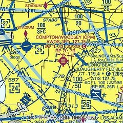
| Sectional chart |
|---|
|
| Airport distance calculator |
|---|
|
|
| Sunrise and sunset |
|---|
|
Times for 14-Feb-2026
| | Local
(UTC-8) | | Zulu
(UTC) |
|---|
| Morning civil twilight | | 06:14 | | 14:14 |
| Sunrise | | 06:39 | | 14:39 |
| Sunset | | 17:35 | | 01:35 |
| Evening civil twilight | | 18:01 | | 02:01 |
|
| Current date and time |
|---|
| Zulu (UTC) | 14-Feb-2026 10:30:42 |
|---|
| Local (UTC-8) | 14-Feb-2026 02:30:42 |
|---|
|
| METAR |
|---|
KHHR
5nm W | 140953Z AUTO VRB03KT 10SM SCT010 14/12 A3009 RMK AO2 SLP187 T01390117 $
|
KLGB
6nm SE | 141023Z AUTO 00000KT 10SM OVC015 13/11 A3008 RMK AO2 T01280111 $
|
KTOA
7nm SW | 140347Z 00000KT 10SM SKC 13/06 A3004 RMK LAST
|
KLAX
7nm W | 140953Z 06005KT 9SM SCT010 13/12 A3008 RMK AO2 SLP186 T01280117
|
KSMO
13nm NW | 140951Z AUTO 03004KT 10SM BKN014 13/11 A3009 RMK AO2 SLP187 T01280111 $
|
KSLI
13nm SE | 140955Z AUTO 06004KT 6SM BR FEW015 10/09 A3004 RMK AO2 SLP176 T01030087
|
KFUL
13nm E | 140953Z AUTO 10003KT 10SM CLR 11/10 A3008 RMK AO2 SLP185 T01110100
|
KEMT
15nm NE | 140245Z 21006KT 10SM CLR 17/09 A3002
|
KBUR
20nm N | 140953Z 00000KT 10SM CLR 10/07 A3009 RMK AO2 SLP179 T01000067
|
|
| TAF |
|---|
KLGB
6nm SE | 140531Z 1406/1506 VRB03KT P6SM SCT250 FM142100 20006KT P6SM BKN250 FM150400 VRB03KT P6SM BKN030
|
KLAX
7nm W | 140802Z 1408/1512 09007KT P6SM FEW012 FM141800 12004KT P6SM SCT025 SCT250 FM142100 24010KT P6SM BKN250 FM150300 24008KT P6SM BKN050 FM150400 VRB03KT P6SM BKN030 FM150800 VRB03KT P6SM BKN030
|
KSMO
13nm NW | 140531Z 1406/1506 VRB03KT P6SM FEW250 FM141600 VRB03KT P6SM SCT025 FM142100 21008KT P6SM BKN050 FM150400 VRB03KT P6SM BKN030
|
KSLI
13nm SE | 140500Z 1405/1511 VRB06KT 9999 SKC QNH3002INS BECMG 1411/1412 VRB06KT 8000 BR BKN011 OVC018 QNH3007INS BECMG 1412/1413 VRB06KT 8000 BR SCT011 SCT018 QNH3005INS TX19/1423Z TN12/1415Z
|
KBUR
20nm N | 140816Z 1408/1506 VRB03KT P6SM BKN008 FM141000 VRB03KT P6SM SKC FM142100 16006KT P6SM SCT250 FM150400 VRB03KT P6SM BKN050
|
|
| NOTAMs |
|---|
NOTAMs are issued by the DoD/FAA and will open in a separate window not controlled by AirNav.
|
|

