FAA INFORMATION EFFECTIVE 15 MAY 2025
Location
| FAA Identifier: | TPF |
| Lat/Long: | 27-54-55.6000N 082-26-57.8000W
27-54.926667N 082-26.963333W
27.9154444,-82.4493889
(estimated) |
| Elevation: | 7.4 ft. / 2.3 m (surveyed) |
| Variation: | 05W (2010) |
| From city: | 3 miles S of TAMPA, FL |
| Time zone: | UTC -4 (UTC -5 during Standard Time) |
| Zip code: | 33606 |
Airport Operations
| Airport use: | Open to the public |
| Activation date: | 04/1940 |
| Control tower: | no |
| ARTCC: | MIAMI CENTER |
| FSS: | SAINT PETERSBURG FLIGHT SERVICE STATION |
| NOTAMs facility: | TPF (NOTAM-D service available) |
| Attendance: | 0700-1900 |
| Pattern altitude: | 907.4 ft. MSL |
| Wind indicator: | lighted |
| Segmented circle: | yes |
| Lights: | ACTVT REIL RWY 22; PAPI RWY 04 & 36; MIRL RWY 04/22 & 18/36 - CTAF. |
| Beacon: | white-green (lighted land airport)
Operates sunset to sunrise. |
Airport Communications
| CTAF/UNICOM: | 122.725 |
| WX AWOS-3: | 118.925 (813-251-6824) |
| TAMPA APPROACH: | 119.9 |
| TAMPA DEPARTURE: | 119.9 |
| CLEARANCE DELIVERY: | 119.8 ;IFR |
| WX ASOS at TPA (6 nm NW): | 126.45 (813-296-2752) |
| WX AWOS-3 at VDF (8 nm NE): | 121.125 (813-630-0924) |
| WX ASOS at PIE (13 nm W): | 134.5 (727-502-6385) |
| WX ASOS at SPG (13 nm SW): | 118.875 (727-821-4334) |
| WX AWOS-3 at PCM (16 nm E): | 120.025 (813-764-8259) |
| WX AWOS-3P at CLW (17 nm W): | 119.225 (727-462-6383) |
Nearby radio navigation aids
| VOR radial/distance | | VOR name | | Freq | | Var |
|---|
| PIEr093/12.5 | | ST PETERSBURG VORTAC | | 116.40 | | 05W |
| LALr259/23.5 | | LAKELAND VORTAC | | 116.00 | | 01E |
| SRQr016/31.1 | | SARASOTA VOR/DME | | 117.00 | | 05W |
| NDB name | | Hdg/Dist | | Freq | | Var | | ID |
|---|
| CAPOK | | 115/14.3 | | 360 | | 05W | | PI | .--. .. |
Airport Services
| Fuel available: | 100LL JET-A |
| Parking: | hangars and tiedowns |
| Airframe service: | MAJOR |
| Powerplant service: | MAJOR |
| Bottled oxygen: | LOW |
| Bulk oxygen: | HIGH/LOW |
Runway Information
Runway 4/22
| Dimensions: | 3583 x 100 ft. / 1092 x 30 m |
| Surface: | asphalt, in excellent condition |
| Weight bearing capacity: | | PCN 26 /F/A/X/T | | Single wheel: | 75.0 | | Double wheel: | 108.0 |
|
| Runway edge lights: | medium intensity |
| RUNWAY 4 | | RUNWAY 22 |
| Latitude: | 27-54.653500N | | 27-55.126017N |
| Longitude: | 082-27.244167W | | 082-26.844000W |
| Elevation: | 6.9 ft. | | 6.0 ft. |
| Traffic pattern: | right | | left |
| Runway heading: | 042 magnetic, 037 true | | 222 magnetic, 217 true |
| Displaced threshold: | 179 ft. | | 180 ft. |
| Declared distances: | TORA:3403 TODA:3403 ASDA:3403 LDA:3224 | | TORA:3404 TODA:3404 ASDA:3404 LDA:3403 |
| Markings: | nonprecision, in good condition | | nonprecision, in good condition |
| Visual slope indicator: | 4-light PAPI on left (3.50 degrees glide path) | | |
| Runway end identifier lights: | | | yes |
| Touchdown point: | yes, no lights | | yes, no lights |
| Obstructions: | 6 ft. fence, lighted, 200 ft. from runway, 222 ft. right of centerline, 1:1 slope to clear
6 FT FENCE 200 FT FM RWY END 222 FT R. | | 30 ft. boat, 415 ft. from runway, 250 ft. left of centerline, 7:1 slope to clear
RWY 22 APCH RATIO 26:1 TO THE DTHR. |
Runway 18/36
| Dimensions: | 2687 x 75 ft. / 819 x 23 m |
| Surface: | asphalt, in fair condition |
| Weight bearing capacity: | | PCN 8 /F/B/X/T | | Single wheel: | 27.0 | | Double wheel: | 42.0 |
|
| Runway edge lights: | medium intensity |
| RUNWAY 18 | | RUNWAY 36 |
| Latitude: | 27-55.197585N | | 27-54.757473N |
| Longitude: | 082-26.887140W | | 082-26.826555W |
| Elevation: | 5.9 ft. | | 6.3 ft. |
| Traffic pattern: | left | | right |
| Runway heading: | 178 magnetic, 173 true | | 358 magnetic, 353 true |
| Displaced threshold: | 203 ft. | | 201 ft. |
| Declared distances: | TORA:2687 TODA:2687 ASDA:2574 LDA:2371 | | TORA:2487 TODA:2487 ASDA:2512 LDA:2311 |
| Markings: | nonprecision, in fair condition | | nonprecision, in fair condition |
| Visual slope indicator: | | | 2-light PAPI on right (3.00 degrees glide path) |
| Touchdown point: | yes, no lights | | yes, no lights |
| Obstructions: | 6 ft. fence, lighted, 200 ft. from runway, 93 ft. right of centerline, 1:1 slope to clear
RWY 18 HAS 6 FT FENCE AND 15 FT ROAD 200 FT FM RWY END 93 FT RIGHT. | | 5 ft. fence, lighted, 200 ft. from runway, 150 ft. left of centerline, 1:1 slope to clear
RWY 36 HAS 5 FT FENCE AND 15 FT ROAD 200 FT FM RWY END 150 FT L. |
Airport Ownership and Management from official FAA records
| Ownership: | Publicly-owned |
| Owner: | HILLSBOROUGH COUNTY AVIATION AUTH
PO BOX 22287
TAMPA, FL 33622
Phone 813-870-8711
813-251-1752 |
| Manager: | BRETT FAY
PO BOX 22287
TAMPA, FL 33606
Phone 813-870-8735 |
Additional Remarks
| A30A-22 | SHIP CHANNEL APCH END. |
| A30A-18 | SHIP CHANNEL APCH END. |
| - | OCEAN VESSEL SHIP CHANNEL EAST. |
| - | GULLS ON AND INVOF ARPT. |
| - | TWY E CLSD TO ACFT WITH WING SPANS IN EXCESS OF 40 FT. |
| - | ALERT: MACDILL AFB LCTD 4 MILES SW & HOSP HEL TFC 1 NM NORTH USING UNICOM 122.825. |
| - | FOR CD CTC TAMPA APCH AT 813-878-2528 |
Instrument Procedures
NOTE: All procedures below are presented as PDF files. If you need a reader for these files, you should download the free Adobe Reader.NOT FOR NAVIGATION. Please procure official charts for flight.
FAA instrument procedures published for use from 15 May 2025 at 0901Z to 13 June 2025 at 0900z.
STARs - Standard Terminal Arrivals |
|---|
| DADES TWO (RNAV) **NEW** | |
2 pages:
[1] [2] (428KB) |
| RAYZZ THREE (RNAV) **NEW** | |
2 pages:
[1] [2] (439KB) |
IAPs - Instrument Approach Procedures |
|---|
| RNAV (GPS) RWY 22 | |
download (238KB) |
| RNAV (GPS) RWY 36 | |
download (247KB) |
| NOTE: Special Alternate Minimums apply | |
download (22KB) |
| NOTE: Special Take-Off Minimums/Departure Procedures apply | |
download (309KB) |
Other nearby airports with instrument procedures:
KMCF - MacDill Air Force Base (5 nm SW)
KTPA - Tampa International Airport (6 nm NW)
KVDF - Tampa Executive Airport (8 nm NE)
KPIE - St Pete-Clearwater International Airport (13 nm W)
KSPG - Albert Whitted Airport (13 nm SW)
KPCM - Plant City Airport (16 nm E)
KCLW - Clearwater Air Park (17 nm W)
|
|

Road maps at:
MapQuest
Bing
Google
| Aerial photo |
|---|
WARNING: Photo may not be current or correct
 Photo courtesy of PhotosFromTheAir.com
Photo taken 27-Feb-2012
looking north.
Photo courtesy of PhotosFromTheAir.com
Photo taken 27-Feb-2012
looking north.
Do you have a better or more recent aerial photo of Peter O Knight Airport that you would like to share? If so, please send us your photo.
|
| Sectional chart |
|---|
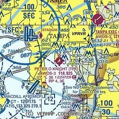
|
| Airport distance calculator |
|---|
|
|
| Sunrise and sunset |
|---|
|
Times for 22-May-2025
| | Local
(UTC-4) | | Zulu
(UTC) |
|---|
| Morning civil twilight | | 06:12 | | 10:12 |
| Sunrise | | 06:38 | | 10:38 |
| Sunset | | 20:15 | | 00:15 |
| Evening civil twilight | | 20:41 | | 00:41 |
|
| Current date and time |
|---|
| Zulu (UTC) | 22-May-2025 05:39:01 |
|---|
| Local (UTC-4) | 22-May-2025 01:39:01 |
|---|
|
| METAR |
|---|
| KTPF | 220515Z AUTO RMK AO2 PWINO
|
KMCF
5nm SW | 220455Z AUTO 27005KT 10SM FEW017 28/24 A2997 RMK AO2 SLP151 T02760242 403360221
|
KTPA
5nm NW | 220521Z 28008KT 10SM SCT018 SCT025 28/24 A2997 RMK AO2 T02830244
|
KVDF
8nm NE | 220515Z AUTO 00000KT 10SM CLR 26/24 A2998 RMK AO2
|
KPIE
12nm W | 220453Z AUTO 28007KT 10SM CLR 27/25 A2997 RMK AO2 SLP149 T02720250 403330239
|
KSPG
13nm SW | 220453Z AUTO VRB03KT 10SM FEW019 SCT026 27/25 A2996 RMK AO2 SLP144 T02720250 403000256
|
KPCM
16nm E | 220515Z AUTO 27004KT 10SM CLR 26/23 A2999 RMK AO2
|
KCLW
17nm W | 220515Z AUTO 29004KT 10SM SCT017 BKN023 BKN028 26/23 A2997 RMK AO2
|
|
| TAF |
|---|
KMCF
5nm SW | 220100Z 2201/2307 30010KT 9999 SCT020 QNH2996INS BECMG 2208/2209 32009KT 9999 SCT030 BKN120 QNH2993INS BECMG 2211/2212 33012KT 9999 VCSH SCT020 BKN110 QNH2998INS BECMG 2213/2214 36010G15KT 8000 -SHRA BKN040 QNH3000INS BECMG 2217/2218 02012KT 9999 NSW SCT040 BKN090 QNH2999INS BECMG 2220/2221 36010KT 8000 -SHRA BKN050 QNH2996INS BECMG 2300/2301 01009KT 9999 NSW BKN045 BKN100 QNH2998INS TX32/2221Z TN24/2209Z
|
KTPA
5nm NW | 220256Z 2203/2306 28007KT P6SM FEW020 BKN250 FM221300 33007KT P6SM VCSH SCT030 BKN100 BKN250 FM221800 31008KT P6SM VCTS SCT030CB BKN100 BKN250 FM222000 30009KT P6SM SCT030 BKN250
|
KPIE
12nm W | 211731Z 2118/2218 26012G18KT P6SM SCT040 SCT250 FM220000 28008KT P6SM FEW030 SCT250 FM220900 31005KT P6SM VCSH SCT020 BKN200 FM221300 36006KT P6SM VCSH SCT020 BKN050 FM221700 36007KT P6SM SCT035 BKN200
|
|
| NOTAMs |
|---|
NOTAMs are issued by the DoD/FAA and will open in a separate window not controlled by AirNav.
|
|


