FAA INFORMATION EFFECTIVE 19 MARCH 2026
Location
| FAA Identifier: | CPM |
| Lat/Long: | 33-53-23.7000N 118-14-37.7000W
33-53.395000N 118-14.628333W
33.8899167,-118.2438056
(estimated) |
| Elevation: | 98.7 ft. / 30.1 m (surveyed) |
| Variation: | 14E (1985) |
| From city: | 2 miles SW of COMPTON, CA |
| Time zone: | UTC -7 (UTC -8 during Standard Time) |
| Zip code: | 90220 |
Airport Operations
| Airport use: | Open to the public |
| Control tower: | no |
| ARTCC: | LOS ANGELES CENTER |
| FSS: | HAWTHORNE FLIGHT SERVICE STATION |
| NOTAMs facility: | HHR (NOTAM-D service available) |
| Attendance: | CONTINUOUS |
| Pattern altitude: | 998.7 ft. MSL |
| Wind indicator: | lighted |
| Segmented circle: | yes |
| Lights: | ACTVT REIL & PAPI RWY 25L; MIRL RWY 07R/25L; N AND S PARL TWYS - CTAF. |
| Beacon: | white-green (lighted land airport)
Operates sunset to sunrise. |
Airport Communications
| CTAF/UNICOM: | 123.05 |
| WX AWOS-3PT: | 127.150 (310-631-3022) |
| WX ASOS at HHR (5 nm NW): | PHONE 310-973-8930 |
| WX ASOS at LGB (6 nm SE): | PHONE 562-247-0378 |
| WX AWOS-3PT at TOA (7 nm SW): | PHONE 310-534-2847 |
| WX ASOS at LAX (9 nm W): | PHONE 310-602-6051 |
| WX ASOS at SMO (13 nm NW): | PHONE 310-392-6453 |
| WX ASOS at FUL (13 nm E): | PHONE 714-870-1372 |
| WX AWOS-3PT at EMT (16 nm NE): | 118.75 ((626) 444-1107) |
| WX ASOS at BUR (20 nm N): | PHONE 818-841-1384 |
Nearby radio navigation aids
| VOR radial/distance | | VOR name | | Freq | | Var |
|---|
| LAXr090/9.7 | | LOS ANGELES VORTAC | | 113.60 | | 15E |
| SLIr289/11.4 | | SEAL BEACH VORTAC | | 115.70 | | 15E |
| SMOr109/12.8 | | SANTA MONICA VOR/DME | | 110.80 | | 15E |
| VNYr133/23.5 | | VAN NUYS VOR/DME | | 113.10 | | 15E |
| POMr229/25.4 | | POMONA VORTAC | | 110.40 | | 15E |
| ELBr283/28.6 | | EL TORO VOR/DME | | 117.20 | | 14E |
| SXCr001/32.1 | | SANTA CATALINA VORTAC | | 114.15 | | 15E |
| PDZr252/35.6 | | PARADISE VORTAC | | 112.20 | | 15E |
| RALr250/(39.7) | | RIVERSIDE VOR | | 108.60 | | 14E |
Airport Services
| Fuel available: | 100LL |
| Parking: | tiedowns |
| Airframe service: | MAJOR |
| Powerplant service: | MAJOR |
| Bottled oxygen: | NONE |
| Bulk oxygen: | NONE |
Runway Information
Runway 7L/25R
| Dimensions: | 3323 x 60 ft. / 1013 x 18 m |
| Surface: | asphalt/aggregate friction seal coat, in good condition |
| Weight bearing capacity: | |
| Operational restrictions: | CLSD NIGHTS INDEFLY; ONLY VFR OPNS DURG DAY. |
| RUNWAY 7L | | RUNWAY 25R |
| Latitude: | 33-53.410100N | | 33-53.413187N |
| Longitude: | 118-14.956927W | | 118-14.300008W |
| Elevation: | 98.7 ft. | | 85.3 ft. |
| Traffic pattern: | right | | left |
| Runway heading: | 075 magnetic, 089 true | | 255 magnetic, 269 true |
| Displaced threshold: | 738 ft. | | 667 ft. |
| Markings: | basic, in good condition | | basic, in good condition |
| Runway end identifier lights: | no | | no |
| Touchdown point: | yes, no lights | | yes, no lights |
| Obstructions: | 19 ft. road, 200 ft. from runway
6 FT FENCE 70 FT FM THLD PERPENDICULAR TO CNTRLN +8 FT WALL 90 FT FM THLD PERPENDICULAR TO CNTRLN; +30 FT PLINE 200 FT FM RY END 125 FT R TO 125 FT L. | | 15 ft. road, 200 ft. from runway
+6 FT FENCE 60 FT TO 70 FT FROM THRESHOLD, +8 FT WALL 75 FT TO 85 FT FROM THRESHOLD, +15 FT STREET 125 FT R 105 FT TO 200 FT FROM THRESHOLD THROUGH 125 FT L 120 FT TO 200 FT FROM THR. |
Runway 7R/25L
| Dimensions: | 3322 x 60 ft. / 1013 x 18 m |
| Surface: | asphalt/aggregate friction seal coat, in good condition |
| Weight bearing capacity: | |
| Runway edge lights: | medium intensity |
| RUNWAY 7R | | RUNWAY 25L |
| Latitude: | 33-53.377077N | | 33-53.380268N |
| Longitude: | 118-14.956708W | | 118-14.299880W |
| Elevation: | 98.6 ft. | | 86.3 ft. |
| Traffic pattern: | right | | left |
| Runway heading: | 075 magnetic, 089 true | | 255 magnetic, 269 true |
| Displaced threshold: | 737 ft. | | 667 ft. |
| Markings: | basic, in good condition | | basic, in good condition |
| Visual slope indicator: | | | 2-light PAPI on right (4.00 degrees glide path) |
| Runway end identifier lights: | no | | yes |
| Touchdown point: | yes, no lights | | yes, no lights |
| Obstructions: | 19 ft. road, 200 ft. from runway
6 FT FENCE 70 FT FM THLD PERPENDICULAR TO CNTRLN +8 FT WALL 90 FT FM THLD PERPENDICULAR TO CNTRLN; +30 FT PLINE 125 FT FM RY END 125 FT R TO 125 FT L. | | 15 ft. road, 200 ft. from runway
+6 FT FENCE 45 FT TO 70 FT FROM THRESHOLD, +8 FT WALL 70 FT TO 90 FT FROM THRESHOLD, +15 FT STREET 125 FT R 120 FT TO 200 FT FROM THRESHOLD THROUGH 125 FT L 120 FT TO 200 FT FROM THR. |
Airport Ownership and Management from official FAA records
| Ownership: | Publicly-owned |
| Owner: | COUNTY OF LOS ANGELES
900 S. FREMONT AVE
ALHAMBRA, CA 92803
Phone 626-300-4600
LA COUNTY CTC: PAUL MASELBAS, 626-300-4600 X4615. |
| Manager: | LATANYA COLLIER
901 W ALONDRA BLVD
COMPTON, CA 90220-3528
Phone 310-631-6140 |
Additional Remarks
| - | PLANES PARKED 145 FT NORTH OF CENTERLINE 07L/25R AND 158 FT SOUTH OF CENTERLINE 07R/25L. |
| - | REQ ALL TRAFFIC REMAIN SOUTH OF AIRPORT. AVOID OVERFLIGHT OF SCHOOLS 2900 FT EAST. |
| - | ONLY SOUTH SIDE OF NORTH PARALLEL TAXIWAY LIGHTED; ONLY NORTH SIDE OF SOUTH PARALLEL TAXIWAY LIGHTED. |
| - | RY 25L/25R CALM WIND RUNWAY. |
| - | NO TOUCH AND GO LANDINGS |
| - | SKID EQUIPPED HELICOPTERS ARE NOT PERMITTED TO TOUCH DOWN ON RUNWAYS. HELICOPTER OPERATIONS RESTRICTED TO THE RUNWAYS AND SOUTH APRONS. |
| - | FOR CD CTC SOCAL APCH AT 800-448-3724. |
| - | ACFT PARKED IN TIE-DOWNS ALONG TWY A AND TWY B ARE WI THE TWY OBJECT FREE AREA (TOFA). |
Instrument Procedures
There are no published instrument procedures at KCPM.
Some nearby airports with instrument procedures:
KHHR - Jack Northrop Field/Hawthorne Municipal Airport (5 nm NW)
KLGB - Long Beach Airport (Daugherty Field) (6 nm SE)
KTOA - Zamperini Field Airport (7 nm SW)
KLAX - Los Angeles International Airport (9 nm W)
KSLI - Los Alamitos Army Airfield (11 nm SE)
KSMO - Santa Monica Municipal Airport (13 nm NW)
KFUL - Fullerton Municipal Airport (13 nm E)
KEMT - San Gabriel Valley Airport (16 nm NE)
KBUR - Bob Hope Airport (20 nm N)
|
|

Road maps at:
MapQuest
Bing
Google
| Aerial photo |
|---|
WARNING: Photo may not be current or correct
 Photo by focalflight.com
Photo taken 09-Feb-2017
looking northeast.
Photo by focalflight.com
Photo taken 09-Feb-2017
looking northeast.
Do you have a better or more recent aerial photo of Compton/Woodley Airport that you would like to share? If so, please send us your photo.
|
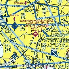
| Sectional chart |
|---|
|
| Airport distance calculator |
|---|
|
|
| Sunrise and sunset |
|---|
|
Times for 09-Apr-2026
| | Local
(UTC-7) | | Zulu
(UTC) |
|---|
| Morning civil twilight | | 06:05 | | 13:05 |
| Sunrise | | 06:31 | | 13:31 |
| Sunset | | 19:18 | | 02:18 |
| Evening civil twilight | | 19:44 | | 02:44 |
|
| Current date and time |
|---|
| Zulu (UTC) | 09-Apr-2026 12:19:01 |
|---|
| Local (UTC-7) | 09-Apr-2026 05:19:01 |
|---|
|
| METAR |
|---|
KHHR
5nm W | 091153Z AUTO 00000KT 10SM BKN012 17/14 A2991 RMK AO2 SLP128 T01720144 10183 20167 55004
|
KLGB
6nm SE | 091153Z AUTO 00000KT 10SM CLR 16/14 A2990 RMK AO2 SLP125 T01560144 10178 20156 56005 $
|
KTOA
7nm SW | 090250Z 27009KT 10SM FEW015 17/14 A2988
|
KLAX
7nm W | 091153Z 08003KT 9SM FEW004 FEW010 BKN250 16/14 A2991 RMK AO2 SLP126 T01610144 10183 20156 56004 $
|
KSMO
13nm NW | 091151Z AUTO 03003KT 10SM CLR 15/13 A2991 RMK AO2 SLP128 T01500128 10172 20144 56003
|
KSLI
13nm SE | 091003Z AUTO 00000KT 6SM BR SCT009 16/15 A2988 RMK AO2 SLP121
|
KFUL
13nm E | 091153Z AUTO 00000KT 10SM CLR 16/13 A2991 RMK AO2 SLP126 T01560128 10178 20156 55005
|
KEMT
15nm NE | 090245Z 20004KT 10SM CLR 21/13 A2987
|
KBUR
20nm N | 091153Z 00000KT 10SM CLR 16/13 A2992 RMK AO2 SLP120 T01610128 10178 20150 56005
|
|
| TAF |
|---|
KLGB
6nm SE | 091126Z 0912/1012 VRB03KT P6SM BKN250 FM091900 19006KT P6SM BKN250 FM092300 30008KT P6SM BKN250 FM100500 VRB03KT P6SM BKN250 FM101100 VRB03KT P6SM BKN015
|
KLAX
7nm W | 091126Z 0912/1018 VRB03KT P6SM BKN250 FM091400 VRB03KT 6SM BR BKN010 FM091700 23005KT 6SM HZ SCT010 FM091900 26012KT P6SM BKN250 FM100300 25008KT P6SM BKN250 FM100800 VRB03KT P6SM BKN250 FM101100 11005KT P6SM BKN012 FM101700 23005KT 6SM HZ SCT010
|
KSMO
13nm NW | 091126Z 0912/1012 VRB03KT P6SM BKN250 FM091400 VRB03KT P6SM OVC010 FM091800 23008KT P6SM BKN250 FM100400 VRB03KT P6SM BKN250
|
KSLI
13nm SE | 081300Z 0813/0919 VRB06KT 8000 BR BKN007 QNH2986INS BECMG 0818/0819 VRB06KT 9999 NSW SKC QNH2990INS TX23/0823Z TN16/0814Z
|
KBUR
20nm N | 091126Z 0912/1012 VRB03KT P6SM BKN250 FM091800 14006KT P6SM BKN250 FM092000 18008KT P6SM BKN250 FM100400 15006KT P6SM BKN250 FM100700 VRB03KT P6SM BKN250
|
|
| NOTAMs |
|---|
NOTAMs are issued by the DoD/FAA and will open in a separate window not controlled by AirNav.
|
|

