FAA INFORMATION EFFECTIVE 22 JANUARY 2026
Location
| FAA Identifier: | LGB |
| Lat/Long: | 33-49-04.5470N 118-09-06.8060W
33-49.075783N 118-09.113433W
33.8179297,-118.1518906
(estimated) |
| Elevation: | 60.4 ft. / 18.4 m (surveyed) |
| Variation: | 14E (1980) |
| From city: | 3 miles NE of LONG BEACH, CA |
| Time zone: | UTC -8 (UTC -7 during Daylight Saving Time) |
| Zip code: | 90712 |
Airport Operations
| Airport use: | Open to the public |
| Activation date: | 04/1940 |
| Control tower: | yes |
| ARTCC: | LOS ANGELES CENTER |
| FSS: | HAWTHORNE FLIGHT SERVICE STATION |
| NOTAMs facility: | LGB (NOTAM-D service available) |
| Attendance: | CONTINUOUS |
| Wind indicator: | lighted |
| Segmented circle: | no |
| Lights: | WHEN ATCT CLSD ACTVT MALSR RWY 30; REIL RWYS 08R, 12, 26L & 26R; PAPI RWYS 12, 08R, 26L & 26R; HIRL RWY 08R/26L; MIRL RWY 08L/26R - CTAF. HIRL, TDZL & CL LIGHTS RWY 12/30 OPER CONSLY WHEN ATCT CLSD. PAPI RWY 30 OPER CONSLY. |
| Beacon: | white-green (lighted land airport)
Operates sunset to sunrise. |
| Fire and rescue: | ARFF index C |
Airport Communications
| CTAF: | 119.4 |
| UNICOM: | 122.95 |
| ATIS: | 127.75 |
| WX ASOS: | PHONE 562-247-0378 |
| LONG BEACH GROUND: | 133.0 257.6 [0615-2345] |
| LONG BEACH TOWER: | 119.4 ;RWY 30 APCH, RWY 12 DEP 120.5 ;RWY 12 APCH, RWY 30 DEP 257.6 [0615-2345] |
| SOCAL APPROACH: | 125.35 |
| SOCAL DEPARTURE: | 127.2 |
| CLEARANCE DELIVERY: | 118.15 |
| ANAHEIM DP: | 125.35 ;RWY 08L, 08R, 12, VENTURA TR 127.2 ;RWY 26L/R, RWY 30, HECTOR, LA 134.9 ;RWY 26L/R, RWY 30 VENTURA TRA |
| BAUBB STAR: | 127.4 |
| CLASS B: | 134.9 |
| DSNEE STAR: | 134.0 |
| EMERG: | 121.5 243.0 |
| EMMLN STAR: | 127.0 |
| FRITR DP: | 125.35 ;RWY 12 127.2 ;RWY 26R, RWY 30 |
| HAWWC DP: | 125.35 ;RWY 8L/R, RWY 12 134.9 ;RWY 26L/R, RWY 30 |
| IC: | 119.4 ;RWY 30 APCH, RWY 12 DEP 120.5 ;RWY 12 APCH, RWY 30 DEP |
| PCIFC STAR: | 127.4 |
| ROOBY STAR: | 134.0 |
| TANDY STAR: | 127.4 |
| TOPMM DP: | 125.35 ;RWY 12 134.9 ;RWY 26R, RWY 30 |
| ZOOMM DP: | 125.35 ;RWY 12 127.2 ;RWY 26R, 30 127.2 ;RWY 26R, RWY 30 |
| WX AWOS-3PT at CPM (6 nm NW): | 127.150 (310-631-3022) |
| WX ASOS at FUL (9 nm E): | PHONE 714-870-1372 |
| WX ASOS at HHR (11 nm NW): | PHONE 310-973-8930 |
| WX ASOS at LAX (15 nm NW): | PHONE 310-602-6051 |
| WX ASOS at SNA (17 nm SE): | PHONE 714-338-2330 |
| WX AWOS-3PT at EMT (17 nm N): | 118.75 ((626) 444-1107) |
| WX ASOS at SMO (19 nm NW): | PHONE 310-392-6453 |
- TA31 RADAR IS REMOTED FROM COAST RATCF; EL TORO MCAS AT SANTA ANA CALIFORNIA.
- SAID IN USE. OPERATE TRANSPONDERS WITH ALTITUDE REPORTING MODE AND ADS-B (IF EQUIPPED) ENABLED ON ALL AIRPORT SURFACES.
- (ATIS PHONE NR) PHONE NRS 562-608-4144/4145/4146.
Nearby radio navigation aids
| VOR radial/distance | | VOR name | | Freq | | Var |
|---|
| SLIr278/5.3 | | SEAL BEACH VORTAC | | 115.70 | | 15E |
| LAXr101/15.6 | | LOS ANGELES VORTAC | | 113.60 | | 15E |
| SMOr112/19.1 | | SANTA MONICA VOR/DME | | 110.80 | | 15E |
| ELBr278/22.7 | | EL TORO VOR/DME | | 117.20 | | 14E |
| POMr214/24.0 | | POMONA VORTAC | | 110.40 | | 15E |
| VNYr130/29.6 | | VAN NUYS VOR/DME | | 113.10 | | 15E |
| SXCr012/29.8 | | SANTA CATALINA VORTAC | | 114.15 | | 15E |
| PDZr244/31.6 | | PARADISE VORTAC | | 112.20 | | 15E |
| RALr243/(35.9) | | RIVERSIDE VOR | | 108.60 | | 14E |
Airport Services
| Fuel available: | 100LL JET-A UL94 |
| Parking: | hangars and tiedowns |
| Airframe service: | MAJOR |
| Powerplant service: | MAJOR |
| Bottled oxygen: | HIGH/LOW |
| Bulk oxygen: | HIGH/LOW |
Runway Information
Runway 12/30
| Dimensions: | 10000 x 200 ft. / 3048 x 61 m |
| Surface: | asphalt/grooved, in good condition |
| Weight bearing capacity: | | Single wheel: | 120.0, MAX LDG WGTS A-330 347000 LBS; A-340 379000 LBS; DC-10-10 DC-10 30/40 & MD-11 379000 LBS; L-1011 354000 LBS. RY 12/30 MAX TKOF WGTS DC-10 30/40 & MD-11 588000 LBS; C-17 538600 LBS. | | Double wheel: | 250.0 | | Double tandem: | 550.0 | | Dual double tandem: | 1120.0 |
|
| Runway edge lights: | high intensity |
| RUNWAY 12 | | RUNWAY 30 |
| Latitude: | 33-49.572188N | | 33-48.412007N |
| Longitude: | 118-09.692077W | | 118-08.288612W |
| Elevation: | 60.4 ft. | | 25.7 ft. |
| Traffic pattern: | left | | left |
| Runway heading: | 121 magnetic, 135 true | | 301 magnetic, 315 true |
| Displaced threshold: | 1350 ft. | | 2000 ft. |
| Declared distances: | TORA:10000 TODA:10000 ASDA:10000 LDA:8650 | | TORA:10000 TODA:10000 ASDA:9414 LDA:7414 |
| Markings: | precision, in good condition | | precision, in good condition |
| Visual slope indicator: | 4-light PAPI on left (3.00 degrees glide path) | | 4-light PAPI on left (3.00 degrees glide path) |
| RVR equipment: | rollout | | touchdown |
| Approach lights: | | | MALSR: 1,400 foot medium intensity approach lighting system with runway alignment indicator lights |
| Runway end identifier lights: | yes | | no |
| Centerline lights: | yes | | yes |
| Touchdown point: | yes, no lights | | yes, lighted |
| Instrument approach: | | | ILS |
| Obstructions: | 8 ft. fence, 200 ft. from runway, 500 ft. left of centerline
6 FT POLE 190 FT FM RY END; FENCE 490 FT L OF CNTRLN. | | 42 ft. tree, 1480 ft. from runway, 630 ft. right of centerline, 30:1 slope to clear
APCH RATIO 50:1 TO DSPLCD THR. |
Runway 8L/26R
| Dimensions: | 6192 x 150 ft. / 1887 x 46 m |
| Surface: | asphalt/grooved, in excellent condition |
| Weight bearing capacity: | | Single wheel: | 120.0 | | Double wheel: | 239.0 | | Double tandem: | 411.0 | | Dual double tandem: | 946.0 |
|
| Runway edge lights: | medium intensity |
| RUNWAY 8L | | RUNWAY 26R |
| Latitude: | 33-49.365615N | | 33-49.361930N |
| Longitude: | 118-09.811463W | | 118-08.588230W |
| Elevation: | 58.1 ft. | | 38.1 ft. |
| Traffic pattern: | left | | right |
| Runway heading: | 076 magnetic, 090 true | | 256 magnetic, 270 true |
| Displaced threshold: | 1305 ft. | | 532 ft. |
| Declared distances: | TORA:6192 TODA:6192 ASDA:6192 LDA:4887 | | TORA:6192 TODA:6192 ASDA:6192 LDA:5660 |
| Markings: | nonprecision, in good condition | | nonprecision, in good condition |
| Visual slope indicator: | | | 4-light PAPI on left (3.10 degrees glide path) |
| Runway end identifier lights: | no | | yes |
| Touchdown point: | yes, no lights | | yes, no lights |
| Obstructions: | 78 ft. pole, 200 ft. from runway, 36 ft. right of centerline, 12:1 slope to clear
6 FT FENCE 190 FT FM RY END WITH OBSTRUCTION LGT. | | 16 ft. road, 300 ft. from runway, 200 ft. right of centerline, 6:1 slope to clear
APCH RATIO 34:1 TO DSPLCD THR. |
Runway 8R/26L
| Dimensions: | 3918 x 100 ft. / 1194 x 30 m |
| Surface: | asphalt, in good condition |
| Weight bearing capacity: | | Single wheel: | 75.0 | | Double wheel: | 109.0 | | Double tandem: | 176.0 |
|
| Runway edge lights: | high intensity |
| Operational restrictions: | RWY 08R/26L NOT AVBL FOR PART 121/PART 380 OPS WITH SKED PAX CARRYING OPS MORE THAN 9 PAX SEATS AND NON-SKED PAX CARRYING OPS MORE THAN 30 PAX SEATS. |
| RUNWAY 8R | | RUNWAY 26L |
| Latitude: | 33-48.833833N | | 33-48.834333N |
| Longitude: | 118-09.678167W | | 118-08.904167W |
| Elevation: | 52.9 ft. | | 34.6 ft. |
| Traffic pattern: | right | | left |
| Runway heading: | 076 magnetic, 090 true | | 256 magnetic, 270 true |
| Declared distances: | TORA:3918 TODA:3918 ASDA:3918 LDA:3918 | | TORA:3918 TODA:3918 ASDA:3918 LDA:3918 |
| Markings: | nonprecision, in good condition | | nonprecision, in good condition |
| Visual slope indicator: | 4-light PAPI on left (3.00 degrees glide path) | | 4-light PAPI on left (3.00 degrees glide path) |
| Runway end identifier lights: | yes | | yes |
| Touchdown point: | yes, no lights | | yes, no lights |
| Obstructions: | 102 ft. tower, lighted, 2500 ft. from runway, 500 ft. right of centerline, 22:1 slope to clear
LGTD TOWER 152 FT AGL 2500 FT WEST & 500 FT SOUTH OF RY THLD. | | 61 ft. trees, 1420 ft. from runway, 300 ft. right of centerline, 20:1 slope to clear |
Helipad H3
| Dimensions: | 300 x 35 ft. / 91 x 11 m |
| Surface: | asphalt, in good condition |
| Latitude: | 33-49.227833N | | |
| Longitude: | 118-09.062167W | | |
| Elevation: | 41.9 ft. | | |
| Traffic pattern: | left | | left |
| Markings: | numbers only, in good condition | | |
Helipad H2
| Dimensions: | 20 x 20 ft. / 6 x 6 m |
| Surface: | asphalt, in good condition |
| Latitude: | 33-49.192333N | | |
| Longitude: | 118-08.998833W | | |
| Elevation: | 40.1 ft. | | |
| Traffic pattern: | left | | left |
| Markings: | numbers only, in good condition | | |
Helipad H4
| Dimensions: | 20 x 20 ft. / 6 x 6 m |
| Surface: | asphalt, in good condition |
| Latitude: | 33-49.257000N | | |
| Longitude: | 118-09.128500W | | |
| Elevation: | 43.0 ft. | | |
| Traffic pattern: | left | | left |
| Markings: | numbers only, in good condition | | |
Helipad H5
| Dimensions: | 20 x 20 ft. / 6 x 6 m |
| Surface: | asphalt, in good condition |
| Latitude: | 33-48.921833N | | |
| Longitude: | 118-09.294500W | | |
| Elevation: | 41.4 ft. | | |
| Traffic pattern: | left | | left |
| Markings: | numbers only, in good condition | | |
Airport Ownership and Management from official FAA records
| Ownership: | Publicly-owned |
| Owner: | CITY OF LONG BEACH
CITY HALL 333 W. OCEAN
LONG BEACH, CA 90802
Phone 562-570-2640 |
| Manager: | CYNTHIA GUIDRY
4100 DONALD DOUGLAS DR
LONG BEACH, CA 90808
Phone (562) 570-2605
JUAN LOPEZ-RIOS (DEPUTY DIR) 562-570-2608. RON REEVES (SUPT ARPT OPNS) 562-570-1251. ARPT BUR FAX 562-570-2601; NOISE OFC 562-570-2635; PUB AFFAIRS 562-570-2665. |
Additional Remarks
| A39-08L/26R | PCR VALUE: 599/F/B/X/T |
| A39-12/30 | PCR VALUE: 721/F/A/X/T |
| A39-08R/26L | PCR VALUE: 297/F/C/X/T |
| - | 6 FT LIGHTED CHAIN LINK FENCE LCTD 130 FT SOUTH OF CNTRLN OF TWY F. FENCE BEGINS NW CORNER OF ATCT & EXTENDS 400 FT TO WEST. |
| - | ENGINE RUN-UPS, OTHER THAN PRE-FLIGHT, ARE LIMITED TO HRS OF 0700-2100 WEEKDAYS & 0900-2100 WEEKENDS & HOLIDAYS. |
| - | HELIPAD H2, H4, & H5 20 X 20 ASPH. HELIPAD H3 35 X 300 ASPH. |
| - | RY 12/30 FAA STRENGTH EVALUATION DC-10-10 440000 LBS; DC-10-30 550000 LBS; L-1011 460000 LBS. |
| - | MAX LDG WGT FOR C17AT OR BYD GLIDE SLOPE OR RY AIMING POINT MARKING 538600 LBS; RY 30 LDG PRIOR TORY AIMING POINT MARKING 344000 LBS. |
| - | AIRSHIPS MOORED IN INFIELD AND OPERATING INVOF ARPT. |
| - | MAX TKOF WGT DC-10 30/40 & MD-11 588100 LBS; C-17 538600 LBS. TWYS D3 & L3 WGT LIMITS A-340 DC-10 30/40 & MD-11 541000 LBS; C-17 450000 LBS. |
| - | THE FLWG WT LMTNS ARE IMPOSED BASED ON POTENTIAL STRUCTURAL STRENGTH OF LAKEWOOD BLVD AND SPRING STREET TUNNELS: RWY 12/30 MAX LDG WTS A-330 347000 LBS; A-340 379000 LBS; DC-10-10, DC-10-30/40 & MD-11 379000 LBS; L-1011 354000 LBS. RWY 12/30 MAX TKOF WTS DC-10-30/40 & MD-11 588000 LBS; C-17 538600 LBS. |
| - | NO TWY ACCESS TO RWY 08L W OF TWY D; 4897 FT REMAINING ON RWY 08L FROM TWY D. |
| - | 24 HR PRIOR NOTICE REQD FOR MIL JETS AND CIVILIAN NON-STAGE III JETS; CTC NOISE OFC 562-570-2635 MON-FRI 0800-1700. |
| - | ALL RYS CLSD 2200-0700 LCL EXCP RY 12/30. |
| - | BIRDS ON & INV OF ARPT |
| - | TRNG HELIPADS H2, H3 & H4 LOCATED N OF RWY 12/30 MIDFIELD BTN TWYS G & K. TRNG HELIPAD H5 LOCATED S OF RWY 12/30 BTN TWYS D & J FOR HOVER WORK ONLY. |
| - | NO RUNNING LDGS/TKOFS BY HELS WITH SKID-TYPE LDG GEAR, ON RWY 08L-26R. ROLLING LDGS/TKOFS WITH HELS WITH WHEEL-TYPE LDG GEAR ARE PMTD. |
| - | TOUCH & GO, STOP & GO, PRACTICE LOW APCH, VFR PRACTICE MISSED APCH ONLY PMTD 0700-1900 WKDAYS & 0800-1500 WKENDS & HOLS ONLY ON RWYS 08L/26R & 08R/26L. |
| - | NO FLD COND NOTAMS AVBL 2200-0700. |
| - | ALL ACFT ON OR ENTERING LEFT DOWNWIND RWY 26L MUST REMAIN NORTH OF SIGNAL HILL UNLESS SPECIFICALLY INSTRUCTED BY ATC OTHERWISE. |
| - | ALL ACFT ON DOWNWIND RWY 26L ARE NOT AUTH TO TURN BASE OR BEGIN DESCENT UNTIL EAST OF RWY 30 UNLESS SPECIFICALLY INSTRUCTED TO DO SO BY ATC. |
| - | ALL ACFT ON DOWNWIND RWY 08L ARE NOT AUTH TO TURN BASE OR BEGIN DESCENT UNTIL WEST OF RWY 12 UNLESS SPECIFICALLY INSTRUCTED TO DO SO BY ATC. |
| - | FOR CD WHEN ATCT CLSD CTC SOCAL APCH AT 800-448-3724. |
| - | RY 12/30 LGTD DISTANCE REMAINING SIGNS WEST SIDE. |
| - | NOISE LIMITS (DECIBELS SGL EVENT NOISE EXPOSURE LEVEL) RWY 26R TKOF 92.0 LDG 88.0; RWY 08L TKOF 88.0 LDG 92.0; RWY 26L TKOF 95.0 LDG 93.0; RWY 08R TKOF 95.0 LDG 92.0. RWYS 12 & 30 0700-2200 TKOF 102.5 LDG 101.5; 0600-0700 & 2200-2300 TKOF 90.0 LDG 90.0; 2300-0600 TKOF 79.0 LDG 79.0. |
| - | TWYS D3 AND L3 WGT LIMITS A340 DC10 30/40 & MD11 541000 LBS; C17 450000 LBS. |
Instrument Procedures
NOTE: All procedures below are presented as PDF files. If you need a reader for these files, you should download the free Adobe Reader.NOT FOR NAVIGATION. Please procure official charts for flight.
FAA instrument procedures published for use from 22 January 2026 at 0901Z to 19 February 2026 at 0900z.
STARs - Standard Terminal Arrivals |
|---|
| BAUBB THREE (RNAV) | |
download (297KB) |
| BAUBB THREE (RNAV) | |
download (297KB) |
| DSNEE SIX (RNAV) | |
2 pages:
[1] [2] (654KB) |
| EMMLN TWO **NEW** | |
2 pages:
[1] [2] (411KB) |
| KAYOH EIGHT | |
download (269KB) |
| PCIFC THREE (RNAV) | |
2 pages:
[1] [2] (495KB) |
| PCIFC THREE (RNAV) | |
2 pages:
[1] [2] (495KB) |
| ROOBY THREE (RNAV) | |
2 pages:
[1] [2] (585KB) |
| TANDY FIVE | |
download (176KB) |
IAPs - Instrument Approach Procedures |
|---|
| ILS OR LOC RWY 30 | |
download (298KB) |
| RNAV (RNP) RWY 12 | |
download (232KB) |
| RNAV (RNP) RWY 26R | |
download (257KB) |
| RNAV (RNP) Y RWY 30 | |
download (227KB) |
| RNAV (GPS) Z RWY 30 | |
download (246KB) |
| VOR OR TACAN RWY 30 | |
download (264KB) |
| ARSENAL VISUAL RWY 30 | |
download (179KB) |
| LA RIVER VISUAL RWY 12 | |
download (157KB) |
| NOTE: Special Alternate Minimums apply | |
download (141KB) |
Departure Procedures |
|---|
| ANAHEIM ONE | |
2 pages:
[1] [2] (444KB) |
| FRITR THREE (RNAV) | |
download (255KB) |
| HAWWC THREE (RNAV) | |
download (302KB) |
| TOPMM FIVE (RNAV) | |
download (265KB) |
| TOPMM FIVE (RNAV) | |
download (265KB) |
| ZOOMM THREE (RNAV) | |
2 pages:
[1] [2] (365KB) |
| NOTE: Special Take-Off Minimums/Departure Procedures apply | |
download (350KB) |
Other nearby airports with instrument procedures:
KSLI - Los Alamitos Army Airfield (5 nm E)
KFUL - Fullerton Municipal Airport (9 nm E)
KTOA - Zamperini Field Airport (9 nm W)
KHHR - Jack Northrop Field/Hawthorne Municipal Airport (11 nm NW)
KLAX - Los Angeles International Airport (15 nm NW)
KSNA - John Wayne/Orange County Airport (17 nm SE)
KEMT - San Gabriel Valley Airport (17 nm N)
KSMO - Santa Monica Municipal Airport (19 nm NW)
|
|

Road maps at:
MapQuest
Bing
Google
| Aerial photo |
|---|
WARNING: Photo may not be current or correct
 Photo by focalflight.com
Photo taken 31-Oct-2015
looking north.
Photo by focalflight.com
Photo taken 31-Oct-2015
looking north.
Do you have a better or more recent aerial photo of Long Beach Airport (Daugherty Field) that you would like to share? If so, please send us your photo.
|
| Sectional chart |
|---|
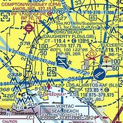
|
CAUTION: Diagram may not be current
 Download PDF
of official airport diagram from the FAA
| Airport distance calculator |
|---|
|
|
| Sunrise and sunset |
|---|
|
Times for 04-Feb-2026
| | Local
(UTC-8) | | Zulu
(UTC) |
|---|
| Morning civil twilight | | 06:22 | | 14:22 |
| Sunrise | | 06:48 | | 14:48 |
| Sunset | | 17:25 | | 01:25 |
| Evening civil twilight | | 17:51 | | 01:51 |
|
| Current date and time |
|---|
| Zulu (UTC) | 04-Feb-2026 08:15:35 |
|---|
| Local (UTC-8) | 04-Feb-2026 00:15:35 |
|---|
|
| METAR |
|---|
| KLGB | 040753Z AUTO 31003KT 9SM CLR 14/12 A3014 RMK AO2 SLP206 T01390117 402890106 $
|
KSLI
7nm SE | 040755Z AUTO 00000KT 7SM CLR 11/10 A3011 RMK AO2 SLP199 T01140096 402590075
|
KTOA
8nm W | 040347Z 13004KT 10SM SKC 14/09 A3016
|
KFUL
9nm E | 040753Z AUTO 33003KT 10SM CLR 13/07 A3014 RMK AO2 SLP205 T01330072 403000089
|
KHHR
11nm NW | 040753Z AUTO 00000KT 9SM CLR 14/12 A3016 RMK AO2 SLP210 T01440117 402780117 $
|
KLAX
13nm NW | 040753Z 00000KT 10SM CLR 16/11 A3016 RMK AO2 SLP209 T01610106 402390117 $
|
KEMT
16nm NE | 040245Z 16003KT 10SM CLR 23/04 A3016
|
KSNA
17nm SE | 040753Z AUTO 00000KT 10SM CLR 14/11 A3015 RMK AO2 SLP208 T01390111 402670117 $
|
KSMO
19nm NW | 040751Z AUTO 00000KT 10SM CLR 14/09 A3016 RMK AO2 SLP210 T01440094 402390106
|
|
| TAF |
|---|
| KLGB | 040520Z 0406/0506 VRB03KT P6SM SKC FM041500 35005KT P6SM SKC FM042100 08008KT P6SM SKC FM050300 VRB03KT P6SM SKC
|
KSLI
7nm SE | 040500Z 0405/0511 VRB06KT 9999 SKC QNH3013INS TX28/0501Z TN14/0415Z
|
KLAX
13nm NW | 040520Z 0406/0512 VRB03KT P6SM SKC FM041300 07004KT P6SM SKC FM041800 VRB03KT P6SM SKC FM042000 27008KT P6SM SKC FM050400 VRB03KT P6SM SKC FM050700 05006KT P6SM SKC
|
KSNA
17nm SE | 040521Z 0406/0506 VRB03KT P6SM SKC FM041500 05008KT P6SM SKC FM050200 VRB04KT P6SM FEW250
|
KSMO
19nm NW | 040520Z 0406/0506 VRB03KT P6SM SKC FM041000 04005KT P6SM SKC FM042000 23006KT P6SM SKC FM050100 VRB03KT P6SM SKC
|
|
| NOTAMs |
|---|
NOTAMs are issued by the DoD/FAA and will open in a separate window not controlled by AirNav.
|
|


