FAA INFORMATION EFFECTIVE 15 MAY 2025
Location
| FAA Identifier: | OWD |
| Lat/Long: | 42-11-25.9000N 071-10-22.6000W
42-11.431667N 071-10.376667W
42.1905278,-71.1729444
(estimated) |
| Elevation: | 49.2 ft. / 15.0 m (surveyed) |
| Variation: | 15W (1980) |
| From city: | 2 miles E of NORWOOD, MA |
| Time zone: | UTC -4 (UTC -5 during Standard Time) |
| Zip code: | 02062 |
Airport Operations
| Airport use: | Open to the public |
| Activation date: | 03/1943 |
| Control tower: | yes |
| ARTCC: | BOSTON CENTER |
| FSS: | BRIDGEPORT FLIGHT SERVICE STATION |
| NOTAMs facility: | OWD (NOTAM-D service available) |
| Attendance: | MON - FRI 0800-1700 |
| Wind indicator: | lighted |
| Segmented circle: | no |
| Lights: | WHEN ATCT CLSD ACTVT MALSF RWY 35; PAPI RWYS 10, 17 & 35; MIRL 17/35 - CTAF. |
| Beacon: | white-green (lighted land airport)
Operates sunset to sunrise. |
Airport Communications
| CTAF: | 126.0 |
| ATIS: | 119.95 |
| WX ASOS: | 119.95 (781-762-4314) |
| NORWOOD GROUND: | 121.8 [0700-2000 1 NOV - 30 APR, 0700-2200 1 MAY - 31 OCT] |
| NORWOOD TOWER: | 126.0 [0700-2000 1 NOV - 30 APR, 0700-2200 1 MAY - 31 OCT] |
| BOSTON APPROACH: | 124.1 |
| BOSTON DEPARTURE: | 124.1 |
| CLEARANCE DELIVERY: | 121.8 |
| EMERG: | 121.5 |
| WOONS STAR: | 120.6 |
| WX AWOS-3PT at 1B9 (11 nm S): | 118.675 (774-372-2047) |
| WX ASOS at BOS (13 nm NE): | 135.0 (339-746-6855) |
| WX ASOS at BED (18 nm N): | 124.6 (781-372-5512) |
Nearby radio navigation aids
| VOR radial/distance | | VOR name | | Freq | | Var |
|---|
| BOSr235/12.9 | | BOSTON VOR/DME | | 112.70 | | 16W |
| PVDr036/30.2 | | PROVIDENCE VOR/DME | | 115.60 | | 14W |
| PUTr079/33.1 | | PUTNAM VOR/DME | | 117.40 | | 14W |
| NDB name | | Hdg/Dist | | Freq | | Var | | ID |
|---|
| STOGE | | 350/4.7 | | 397 | | 15W | | OW | --- .-- |
Airport Services
| Fuel available: | 100LL JET-A JET-A+ |
| Parking: | hangars and tiedowns |
| Airframe service: | MAJOR |
| Powerplant service: | MAJOR |
| Bottled oxygen: | LOW |
| Bulk oxygen: | NONE |
Runway Information
Runway 17/35
| Dimensions: | 4007 x 100 ft. / 1221 x 30 m |
| Surface: | asphalt/grooved, in good condition |
| Weight bearing capacity: | | Single wheel: | 58.0 | | Double wheel: | 69.0 |
|
| Runway edge lights: | medium intensity |
| RUNWAY 17 | | RUNWAY 35 |
| Latitude: | 42-11.627430N | | 42-11.030587N |
| Longitude: | 071-10.672240W | | 071-10.294025W |
| Elevation: | 49.2 ft. | | 47.1 ft. |
| Traffic pattern: | left | | right |
| Runway heading: | 170 magnetic, 155 true | | 350 magnetic, 335 true |
| Markings: | nonprecision, in good condition | | nonprecision, in good condition |
| Visual slope indicator: | 4-light PAPI on right (3.00 degrees glide path) | | 4-light PAPI on left (3.00 degrees glide path) |
| Approach lights: | | | MALSF: 1,400 foot medium intensity approach lighting system with sequenced flashers |
| Runway end identifier lights: | no | | no |
| Touchdown point: | yes, no lights | | yes, no lights |
| Instrument approach: | | | LOC/DME |
| Obstructions: | 26 ft. trees, 850 ft. from runway, 125 ft. right of centerline, 25:1 slope to clear | | none |
Runway 10/28
| Dimensions: | 3995 x 75 ft. / 1218 x 23 m |
| Surface: | asphalt, in good condition |
| Weight bearing capacity: | | Single wheel: | 58.0 | | Double wheel: | 69.0 |
|
| RUNWAY 10 | | RUNWAY 28 |
| Latitude: | 42-11.526657N | | 42-11.540803N |
| Longitude: | 071-10.710382W | | 071-09.826097W |
| Elevation: | 48.4 ft. | | 46.1 ft. |
| Traffic pattern: | left | | right
& 35 RIGHT TFC FOR TGL ONLY. |
| Runway heading: | 104 magnetic, 089 true | | 284 magnetic, 269 true |
| Displaced threshold: | 987 ft. | | 212 ft. |
| Declared distances: | TORA:3995 TODA:3995 ASDA:3782 LDA:2795 | | TORA:3995 TODA:3995 ASDA:3808 LDA:3595 |
| Markings: | basic, in good condition | | basic, in good condition |
| Visual slope indicator: | 4-light PAPI on right (4.00 degrees glide path) | | |
| Runway end identifier lights: | no | | no |
| Touchdown point: | yes, no lights | | yes, no lights |
| Obstructions: | 40 ft. trees, 1200 ft. from runway, 125 ft. left of centerline, 25:1 slope to clear
APCH RATIO 50:1 TO DTHR. | | 40 ft. trees, 1000 ft. from runway, 125 ft. right of centerline, 20:1 slope to clear |
Airport Ownership and Management from official FAA records
| Ownership: | Publicly-owned |
| Owner: | TOWN OF NORWOOD
566 WASHINGTON ST
NORWOOD, MA 02062
Phone 781-762-1240 |
| Manager: | MARK RAYMOND
111 ACCESS RD
NORWOOD, MA 02062
Phone 781-255-5615 |
Additional Remarks
| - | 1199 FT /1349 FT MSL/ AND 1249 FT /1349 FT MSL/ TV TWR 8 NM NNW. 1063.5 FT /1184 FT MSL/ TWR 8.5 NM NNW. |
| - | ALL ACFT EXCEEDING 87 EFF PERCEIVED NOISE LEVEL IN DBS OR 75 DBS, AS MEASURED IN PART 36 PROHIBITED FM USING ARPT. |
| - | 125 FT FLAGPOLE 1 MI NW OF RWY 17 APCH. |
| - | GATE 2 TXL LTD TO ACFT WITH WINGSPANS OF 50 FT OR LESS. GATE 3 TXL LTD TO ACFT WITH WINGSPANS OF 45 FT OR LESS. |
| - | BIRD ACTVTY & WILDLIFE INVOF ARPT. |
| - | SN REMOVAL EQUIP BLDG (ABUTTING SOUTH APRON). |
| - | LDG FEES FOR TSNT FIXED-WING ACFT WITH MORE THAN 5000 LBS MAX TOG, AS WELL AS TSNT HELS REGARDLESS OF WT. |
Instrument Procedures
NOTE: All procedures below are presented as PDF files. If you need a reader for these files, you should download the free Adobe Reader.NOT FOR NAVIGATION. Please procure official charts for flight.
FAA instrument procedures published for use from 15 May 2025 at 0901Z to 13 June 2025 at 0900z.
STARs - Standard Terminal Arrivals |
|---|
| WOONS TWO | |
download (156KB) |
IAPs - Instrument Approach Procedures |
|---|
| RNAV (GPS) RWY 35 | |
download (248KB) |
| LOC RWY 35 | |
download (277KB) |
| NOTE: Special Alternate Minimums apply | |
download (138KB) |
Departure Procedures |
|---|
| NORWOOD FIVE | |
2 pages:
[1] [2] (360KB) |
| NOTE: Special Take-Off Minimums/Departure Procedures apply | |
download (532KB) |
Other nearby airports with instrument procedures:
1B9 - Mansfield Municipal Airport (11 nm S)
KBOS - General Edward Lawrence Logan International Airport (13 nm NE)
1B6 - Hopedale Industrial Park Airport (16 nm W)
KBED - Laurence G Hanscom Field Airport (18 nm N)
KTAN - Taunton Municipal Airport/King Field (20 nm S)
|
|

Road maps at:
MapQuest
Bing
Google
| Aerial photo |
|---|
WARNING: Photo may not be current or correct
 Taken in October 2020
looking south.
Taken in October 2020
looking south.
Do you have a better or more recent aerial photo of Norwood Memorial Airport that you would like to share? If so, please send us your photo.
|
| Sectional chart |
|---|
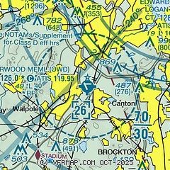
|
CAUTION: Diagram may not be current
 Download PDF
of official airport diagram from the FAA
| Airport distance calculator |
|---|
|
|
| Sunrise and sunset |
|---|
|
Times for 20-May-2025
| | Local
(UTC-4) | | Zulu
(UTC) |
|---|
| Morning civil twilight | | 04:47 | | 08:47 |
| Sunrise | | 05:20 | | 09:20 |
| Sunset | | 20:02 | | 00:02 |
| Evening civil twilight | | 20:35 | | 00:35 |
|
| Current date and time |
|---|
| Zulu (UTC) | 20-May-2025 21:14:53 |
|---|
| Local (UTC-4) | 20-May-2025 17:14:53 |
|---|
|
| METAR |
|---|
| KOWD | 202053Z 07008KT 10SM OVC039 12/07 A2998 RMK AO2 SLP152 T01220067 53019
|
KBOS
13nm NE | 202054Z 06012KT 10SM BKN026 OVC040 11/07 A2998 RMK AO2 SLP153 T01110072 53018
|
KBED
18nm N | 202051Z 08009KT 10SM OVC038 13/07 A2996 RMK AO2 SLP159 T01280067 53016
|
KTAN
20nm S | 202052Z AUTO VRB06KT 10SM OVC039 11/07 A2998 RMK AO2 SLP151 T01110067 53017
|
|
| TAF |
|---|
KBOS
13nm NE | 202009Z 2020/2124 07013KT P6SM SCT025 BKN035 FM210000 05010KT P6SM BKN020 FM211600 06013KT P6SM -DZ OVC020 FM211900 06013G18KT P6SM OVC025
|
KBED
18nm N | 202010Z 2020/2118 07008KT P6SM BKN035 FM210300 03005KT P6SM BKN025 FM210600 05007KT P6SM -DZ OVC020 FM211700 06010KT P6SM -DZ OVC025
|
|
| NOTAMs |
|---|
NOTAMs are issued by the DoD/FAA and will open in a separate window not controlled by AirNav.
|
|


