FAA INFORMATION EFFECTIVE 15 MAY 2025
Location
| FAA Identifier: | TMB |
| Lat/Long: | 25-38-51.2294N 080-25-59.6086W
25-38.853823N 080-25.993477W
25.6475637,-80.4332246
(estimated) |
| Elevation: | 10 ft. / 3.0 m (surveyed) |
| Variation: | 06W (2010) |
| From city: | 13 miles SW of MIAMI, FL |
| Time zone: | UTC -4 (UTC -5 during Standard Time) |
| Zip code: | 33186 |
Airport Operations
| Airport use: | Open to the public |
| Activation date: | 11/1967 |
| Control tower: | yes |
| ARTCC: | MIAMI CENTER |
| FSS: | MIAMI FLIGHT SERVICE STATION |
| NOTAMs facility: | TMB (NOTAM-D service available) |
| Attendance: | CONTINUOUS |
| Pattern altitude: | HEL TFC PAT RWY 09R WI FIXED WING PAT AT OR BLW 500 FT AGL. |
| Wind indicator: | lighted |
| Segmented circle: | yes |
| Lights: | WHEN ATCT CLSD ACTVT MALSR RWY 09R; HIRL RWY 09R/27L; MIRL RWY 13/31; TWY - CTAF. |
| Beacon: | white-green (lighted land airport)
Operates sunset to sunrise. |
| International operations: | customs landing rights airport
US CBP 0900-2400 - 305-969-7511. |
Airport Communications
| CTAF: | 118.9 |
| ATIS: | 124.0 |
| WX ASOS: | 124.0 (305-235-1332) |
| MIAMI EXEC GROUND: | 121.7 [0700-2300] |
| MIAMI EXEC TOWER: | 118.9 124.9 ;270-090 [0700-2300] |
| MIAMI APPROACH: | 125.5 |
| MIAMI DEPARTURE: | 125.5 |
| CLEARANCE DELIVERY: | 133.0 |
| ALTNN DP: | 125.5 |
| BNFSH STAR: | 124.85 |
| BNGOS DP: | 125.5 |
| CSTAL STAR: | 124.85 |
| DORRL DP: | 125.5 |
| FLMGO DP: | 125.5 |
| FOLZZ DP: | 125.5 |
| FOWEE STAR: | 120.5 |
| FROGZ STAR: | 120.5 |
| HURCN DP: | 125.5 |
| IC: | 118.9 |
| LIFRR DP: | 125.5 |
| LUUCE STAR: | 126.05 ;9000 FT 133.775 ;7000 FT |
| MAYNR DP: | 125.5 |
| MELLZ DP: | 125.5 |
| MIAMI DP: | 119.45 ;ALTNN,BEECH,BNGOS,DORRL,FLMG 125.5 ;GWAVA, KETLL, MAYNR TRANSITIO |
| PALMZ STAR: | 120.5 |
| SNDBR STAR: | 120.5 |
| TARPN STAR: | 126.05 ;9000 FT 133.775 ;7000 FT 124.6 ;12000 FT |
| VACAY DP: | 125.5 |
| VFR ADZY: | 118.9 |
| VIICE STAR: | 120.5 |
| WX AWOS-3 at X51 (11 nm SW): | 118.375 (321-385-0383) |
| WX ASOS at MIA (12 nm NE): | 119.15 (305-870-0235) |
| WX ASOS at OPF (18 nm NE): | 125.9 (305-681-4063) |
- SAID IN USE. OPERATE TRANSPONDERS WITH ALTITUDE REPORTING MODE AND ADS-B (IF EQUIPPED) ENABLED ON ALL AIRPORT SURFACES.
Nearby radio navigation aids
| VOR radial/distance | | VOR name | | Freq | | Var |
|---|
| DHPr210/10.2 | | DOLPHIN VORTAC | | 113.90 | | 04W |
| VKZr251/16.3 | | VIRGINIA KEY VOR/DME | | 117.10 | | 04W |
| FLLr215/29.4 | | FORT LAUDERDALE VOR/DME | | 114.40 | | 06W |
Airport Services
| Fuel available: | 100LL JET-A |
| Parking: | hangars and tiedowns |
| Airframe service: | MAJOR |
| Powerplant service: | MAJOR |
| Bottled oxygen: | HIGH/LOW |
| Bulk oxygen: | LOW |
Runway Information
Runway 9R/27L
| Dimensions: | 6000 x 150 ft. / 1829 x 46 m |
| Surface: | asphalt/grooved, in fair condition |
| Weight bearing capacity: | | PCN 32 /F/A/Y/T | | Single wheel: | 87.0 | | Double wheel: | 135.0 | | Double tandem: | 195.0 |
|
| Runway edge lights: | high intensity |
| RUNWAY 9R | | RUNWAY 27L |
| Latitude: | 25-38.574050N | | 25-38.620427N |
| Longitude: | 080-26.465717W | | 080-25.374400W |
| Elevation: | 10.0 ft. | | 7.9 ft. |
| Traffic pattern: | right | | left |
| Runway heading: | 093 magnetic, 087 true | | 273 magnetic, 267 true |
| Markings: | precision, in fair condition | | precision, in fair condition |
| Visual slope indicator: | 4-light PAPI on right (3.00 degrees glide path) | | 4-light PAPI on left (3.00 degrees glide path) |
| Approach lights: | MALSR: 1,400 foot medium intensity approach lighting system with runway alignment indicator lights | | |
| Touchdown point: | yes, no lights | | yes, no lights |
| Instrument approach: | ILS | | |
Runway 9L/27R
| Dimensions: | 5003 x 150 ft. / 1525 x 46 m |
| Surface: | asphalt/grooved, in fair condition |
| Weight bearing capacity: | | PCN 32 /F/A/Y/T | | Single wheel: | 87.0 | | Double wheel: | 135.0 | | Double tandem: | 195.0 |
|
| Runway edge lights: | medium intensity |
| RUNWAY 9L | | RUNWAY 27R |
| Latitude: | 25-39.158120N | | 25-39.196752N |
| Longitude: | 080-26.405025W | | 080-25.494893W |
| Elevation: | 7.8 ft. | | 7.8 ft. |
| Traffic pattern: | left | | right |
| Runway heading: | 093 magnetic, 087 true | | 273 magnetic, 267 true |
| Markings: | nonprecision, in fair condition | | nonprecision, in fair condition |
| Visual slope indicator: | 4-light PAPI on left (3.00 degrees glide path) | | 2-light PAPI on left (3.00 degrees glide path)
PAPI UNUSBL BYD 9 DEGS LEFT & 7 DEGS RIGHT OF CNTRLN. |
| Touchdown point: | yes, no lights | | yes, no lights |
| Obstructions: | none | | 85 ft. tower, marked and lighted, 4453 ft. from runway, 100 ft. right of centerline |
Runway 13/31
| Dimensions: | 4001 x 150 ft. / 1220 x 46 m |
| Surface: | asphalt/grooved, in excellent condition |
| Weight bearing capacity: | | PCN 32 /F/A/Y/T | | Single wheel: | 87.0 | | Double wheel: | 135.0 | | Double tandem: | 195.0 |
|
| Runway edge lights: | medium intensity |
| RUNWAY 13 | | RUNWAY 31 |
| Latitude: | 25-39.034232N | | 25-38.633537N |
| Longitude: | 080-26.447597W | | 080-25.868352W |
| Elevation: | 8.0 ft. | | 7.8 ft. |
| Traffic pattern: | left | | left |
| Runway heading: | 133 magnetic, 127 true | | 313 magnetic, 307 true |
| Markings: | basic, in good condition | | basic, in good condition |
| Visual slope indicator: | 4-light PAPI on left (3.00 degrees glide path) | | |
| Runway end identifier lights: | yes | | |
| Touchdown point: | yes, no lights | | yes, no lights |
| Obstructions: | none | | 29 ft. pole, 1215 ft. from runway, 250 ft. left of centerline, 36:1 slope to clear |
Helipad H1
| Dimensions: | 75 x 75 ft. / 23 x 23 m |
| Surface: | asphalt, in fair condition |
| Latitude: | 25-39.080267N | | |
| Longitude: | 080-25.209367W | | |
| Elevation: | 8.6 ft. | | |
| Traffic pattern: | left | | left |
| Markings: | , in good condition | | |
Airport Ownership and Management from official FAA records
| Ownership: | Publicly-owned |
| Owner: | MIAMI-DADE COUNTY
MIAMI -DADE AVIATION DEPT., P.O. BOX 025504
MIAMI, FL 33102-5504
Phone 305-876-7038
CTC PERSON: LIONEL BECKLES, 305-876-7038. |
| Manager: | JONATHAN SPICER
12800 SW 145TH AVE
MIAMI, FL 33186
Phone 305-869-1702 |
Additional Remarks
| - | ARPT CLSD TO NON-ENG ACFT. |
| - | NOISE SENSITIVE ARPT; FLT TRNG LTD WKDAY 1200-0400Z ; WKEND & OBSERVED HOL 1400-0200Z. |
| - | FOR CD IF UNA TO CTC ON FSS FREQ, CTC MIAMI APCH AT 305-869-5432. |
| - | US CBP AND EAPIS AVBL. 1500-0100Z++-305-969-7511. OPS. MNT FREQ 118.9 DURING CTAF OPS. |
| - | RWY 9L/27R AND RWY 13/31 CLOSED DLY 0400-1200++ WHEN RWY 9R/27L IS IN USE. |
| - | US CBP EXTD HRS AVBL UPON REQ, EMAIL KTMB-ARRIVALS@CBP.DHS.GOV PRIOR TO 2300Z++. |
| - | BIRDS & AGRICULTURAL OPS BLW 200 FT AGL SR TO SS ON AND INVOF ARPT. |
| - | PTNS OF TWY A BTN SPOTS 1 & 2 & PTNS OF TWY D BTN SPOTS 14 & 17 & PTNS OF TWY C BTN SPOTS 13 &14 NOT VSB FM ATCT. SIMUL MOV OF ACFT WITH WINGSPANS IN EXCESS OF 95 FT ARE PRECLUDED FM USING PARL TWY C AND TWY D. |
| - | NOISE ABATEMENT PROC IN EFCT; NO TURNS BLW 1000 FT - 305-869-1700. |
Instrument Procedures
NOTE: All procedures below are presented as PDF files. If you need a reader for these files, you should download the free Adobe Reader.NOT FOR NAVIGATION. Please procure official charts for flight.
FAA instrument procedures published for use from 15 May 2025 at 0901Z to 13 June 2025 at 0900z.
STARs - Standard Terminal Arrivals |
|---|
| ANNEY FOUR | |
2 pages:
[1] [2] (286KB) |
| BNFSH TWO (RNAV) | |
2 pages:
[1] [2] (476KB) |
| BNFSH TWO (RNAV), CONT.2 | |
download (262KB) |
| CSTAL TWO (RNAV) | |
2 pages:
[1] [2] (404KB) |
| CSTAL TWO (RNAV), CONT.2 | |
download (353KB) |
| DVALL FOUR | |
download (145KB) |
| FOWEE TWO | |
download (182KB) |
| FROGZ FOUR (RNAV) | |
2 pages:
[1] [2] (443KB) |
| FROGZ FOUR (RNAV), CONT.2 | |
download (184KB) |
| PALMZ TWO | |
download (185KB) |
| SNDBR THREE (RNAV) | |
2 pages:
[1] [2] (468KB) |
| TARPN THREE (RNAV) **CHANGED** | |
download (214KB) |
| VIICE TWO (RNAV) | |
2 pages:
[1] [2] (369KB) |
| VIICE TWO (RNAV), CONT.2 | |
download (159KB) |
IAPs - Instrument Approach Procedures |
|---|
| ILS OR LOC RWY 09R | |
download (262KB) |
| RNAV (GPS) RWY 09L | |
download (257KB) |
| RNAV (GPS) RWY 09R | |
download (275KB) |
| RNAV (GPS) RWY 27L | |
download (256KB) |
| RNAV (GPS) RWY 27R | |
download (240KB) |
| NOTE: Special Alternate Minimums apply | |
download (123KB) |
Departure Procedures |
|---|
| ALTNN TWO (RNAV) | |
download (252KB) |
| BNGOS FOUR (RNAV) | |
download (268KB) |
| DORRL TWO (RNAV) | |
download (252KB) |
| FLMGO TWO (RNAV) | |
download (254KB) |
| FOLZZ THREE (RNAV) | |
download (298KB) |
| HURCN FOUR (RNAV) | |
2 pages:
[1] [2] (316KB) |
| LIFRR TWO (RNAV) | |
download (245KB) |
| MAYNR THREE (RNAV) | |
2 pages:
[1] [2] (281KB) |
| MELLZ TWO (RNAV) | |
download (243KB) |
| MIAMI TWO | |
2 pages:
[1] [2] (461KB) |
| MIAMI TWO | |
2 pages:
[1] [2] (461KB) |
| NOTE: Special Take-Off Minimums/Departure Procedures apply | |
download (408KB) |
Other nearby airports with instrument procedures:
KHST - Homestead Air Reserve Base (10 nm S)
X51 - Miami Homestead General Aviation Airport (11 nm SW)
KMIA - Miami International Airport (12 nm NE)
KOPF - Miami-Opa Locka Executive Airport (18 nm NE)
07FA - Ocean Reef Club Airport (21 nm SE)
|
|

Road maps at:
MapQuest
Bing
Google
| Aerial photo |
|---|
WARNING: Photo may not be current or correct
 Photo by Michael Kinghorn
Photo taken 07-Dec-2009
Photo by Michael Kinghorn
Photo taken 07-Dec-2009
Do you have a better or more recent aerial photo of Miami Executive Airport that you would like to share? If so, please send us your photo.
|
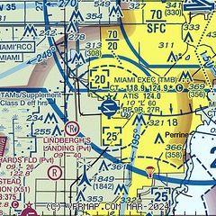
| Sectional chart |
|---|
|
CAUTION: Diagram may not be current
 Download PDF
of official airport diagram from the FAA
| Airport distance calculator |
|---|
|
|
| Sunrise and sunset |
|---|
|
Times for 30-May-2025
| | Local
(UTC-4) | | Zulu
(UTC) |
|---|
| Morning civil twilight | | 06:06 | | 10:06 |
| Sunrise | | 06:32 | | 10:32 |
| Sunset | | 20:07 | | 00:07 |
| Evening civil twilight | | 20:32 | | 00:32 |
|
| Current date and time |
|---|
| Zulu (UTC) | 30-May-2025 06:34:48 |
|---|
| Local (UTC-4) | 30-May-2025 02:34:48 |
|---|
|
| METAR |
|---|
| KTMB | 300553Z AUTO 00000KT 10SM CLR 26/23 A3005 RMK AO2 SLP174 T02560233 10294 20250 58017
|
KMIA
10nm NE | 300553Z 14004KT 10SM FEW028 FEW250 27/23 A3005 RMK AO2 SLP174 T02670228 10289 20267 58016
|
KHST
11nm S | 300555Z AUTO 00000KT 10SM CLR 26/23 A3002 RMK AO2 SLP169 T02600231 10290 20257 57017
|
KOPF
18nm NE | 300553Z AUTO 15005KT 10SM CLR 27/22 A3005 RMK AO2 SLP176 T02670222 10300 20267 58018
|
|
| TAF |
|---|
| KTMB | 300520Z 3006/3106 VRB04KT P6SM SCT050 BKN250 FM301400 19008KT P6SM SCT030 BKN050 FM301800 20010KT P6SM VCTS SCT030CB BKN050 FM310100 VRB04KT P6SM SCT040 SCT250
|
KMIA
10nm NE | 300520Z 3006/3112 VRB04KT P6SM SCT050 BKN250 FM301400 19008KT P6SM SCT030 BKN050 FM301800 17011KT P6SM VCTS SCT030CB BKN050 FM310100 VRB05KT P6SM SCT040 SCT250
|
KHST
11nm S | 300300Z 3003/3109 14006KT 9999 FEW025 SCT250 QNH2999INS BECMG 3014/3015 18010G15KT 9999 SCT032 QNH2992INS BECMG 3023/3024 VRB03KT 9999 SCT024 QNH2989INS TX32/3019Z TN26/3011Z
|
KOPF
18nm NE | 300520Z 3006/3106 VRB05KT P6SM SCT050 BKN250 FM301400 20008KT P6SM SCT030 BKN050 FM301800 18011KT P6SM VCTS SCT030CB BKN050 FM310100 VRB04KT P6SM SCT040 SCT250
|
|
| NOTAMs |
|---|
NOTAMs are issued by the DoD/FAA and will open in a separate window not controlled by AirNav.
|
|


