FAA INFORMATION EFFECTIVE 11 JUNE 2026
Location
| FAA Identifier: | CKZ |
| Lat/Long: | 40-23-21.1000N 075-17-25.7000W
40-23.351667N 075-17.428333W
40.3891944,-75.2904722
(estimated) |
| Elevation: | 567.6 ft. / 173.0 m (surveyed) |
| Variation: | 12W (2005) |
| From city: | 1 mile N of PERKASIE, PA |
| Time zone: | UTC -4 (UTC -5 during Standard Time) |
| Zip code: | 18944 |
Airport Operations
| Airport use: | Open to the public |
| Activation date: | 04/1969 |
| Control tower: | no |
| ARTCC: | NEW YORK CENTER |
| FSS: | WILLIAMSPORT FLIGHT SERVICE STATION |
| NOTAMs facility: | IPT (NOTAM-D service available) |
| Attendance: | 0800-1600 |
| Pattern altitude: | TPA FOR LIGHT ACFT 800 FT AGL; TPA FOR TURBO PROP & JETS 1200 FT AGL. |
| Wind indicator: | lighted |
| Segmented circle: | no |
| Lights: | ACTVT PAPI RWY 08 & 26; MIRL 08/26 - CTAF. |
| Beacon: | white-green (lighted land airport)
Operates sunset to sunrise. |
Airport Communications
| CTAF/UNICOM: | 123.0 |
| WX AWOS-3: | 126.325 (215-257-7291) |
| PHILADELPHIA APPROACH: | 123.8 |
| PHILADELPHIA DEPARTURE: | 123.8 |
| CLEARANCE DELIVERY: | 118.55 |
| WX AWOS-3 at UKT (5 nm NW): | 119.475 (215-538-7610) |
| WX ASOS at DYL (8 nm SE): | 118.875 (215-345-0392) |
| WX AWOS-3 at XLL (14 nm NW): | 127.875 (610-231-3111) |
| WX ASOS at PTW (15 nm SW): | 119.425 (610-495-0823) |
| WX AWOS-3 at LOM (15 nm S): | 118.925 (215-646-1068) |
| WX ASOS at ABE (17 nm NW): | 126.975 (610-477-0813) |
| WX AWOS-3 at N40 (18 nm NE): | 121.725 |
- CLEARANCE DELIVERY PHILADELPHIA APCH TF 800-354-9884.
Nearby radio navigation aids
| VOR radial/distance | | VOR name | | Freq | | Var |
|---|
| PTWr060/15.9 | | POTTSTOWN VORTAC | | 116.50 | | 09W |
| ARDr305/19.3 | | YARDLEY VOR/DME | | 108.20 | | 10W |
| ETXr132/21.3 | | EAST TEXAS VOR/DME | | 110.20 | | 09W |
| FJCr170/21.6 | | ALLENTOWN VORTAC | | 117.50 | | 10W |
| SBJr255/27.6 | | SOLBERG VOR/DME | | 112.90 | | 10W |
| BWZr232/32.5 | | BROADWAY VOR/DME | | 114.20 | | 11W |
| MXEr041/33.2 | | MODENA VORTAC | | 113.20 | | 09W |
| RBVr297/38.1 | | ROBBINSVILLE VORTAC | | 113.80 | | 10W |
| GXUr318/39.1 | | MC GUIRE VORTAC | | 110.60 | | 12W |
Airport Services
| Fuel available: | 100LL JET-A |
| Parking: | hangars and tiedowns |
| Airframe service: | MAJOR |
| Powerplant service: | MAJOR |
| Bottled oxygen: | NONE |
| Bulk oxygen: | NONE |
Runway Information
Runway 8/26
| Dimensions: | 4211 x 100 ft. / 1284 x 30 m |
| Surface: | asphalt/porous friction courses, in good condition |
| Weight bearing capacity: | |
| Runway edge lights: | medium intensity |
| Runway edge markings: | RWY DOES NOT HAVE AIMING POINT. |
| Operational restrictions: | CLSD TO TOUCH & GO LDGS. |
| RUNWAY 8 | | RUNWAY 26 |
| Latitude: | 40-23.230958N | | 40-23.471240N |
| Longitude: | 075-17.853907W | | 075-17.003272W |
| Elevation: | 519.8 ft. | | 567.6 ft. |
| Traffic pattern: | left | | left |
| Runway heading: | 082 magnetic, 070 true | | 262 magnetic, 250 true |
| Displaced threshold: | 266 ft. | | 351 ft. |
| Markings: | nonprecision, in good condition | | nonprecision, in good condition |
| Visual slope indicator: | 2-light PAPI on left (3.78 degrees glide path) | | 2-light PAPI on left (4.00 degrees glide path) |
| Runway end identifier lights: | no | | no |
| Touchdown point: | yes, no lights | | yes, no lights |
| Obstructions: | 23 ft. trees, 247 ft. from runway, 48 ft. right of centerline, 2:1 slope to clear
APCH RATIO 13:1 TO DTHR. | | 55 ft. trees, 490 ft. from runway, 289 ft. right of centerline, 5:1 slope to clear
10 FT BLAST FENCE AT RWY END. 55 FT TREES, 490FT FM RWY END, 289 FT RIGHT. |
Airport Ownership and Management from official FAA records
| Ownership: | Privately-owned |
| Owner: | PENNRIDGE DEVELOPMENT LLC
1100 RIDGE RD
PERKASIE, PA 18944
Phone 215-257-0166 |
| Manager: | JEAN CURRY
1100 N RIDGE RD
PERKASIE, PA 18944
Phone 267-718-4254 |
Additional Remarks
| - | OCCASIONAL DEER AND WILD TURKEYS INVOF RWY. |
| - | SKYDIVING ACT DLY DAWN TO DUSK. |
| - | FOR CD CTC PHILADELPHIA APCH AT 800-354-9884. |
| - | FOR SVC AFT HRS CALL AMGR. |
Instrument Procedures
NOTE: All procedures below are presented as PDF files. If you need a reader for these files, you should download the free Adobe Reader.NOT FOR NAVIGATION. Please procure official charts for flight.
FAA instrument procedures published for use from 11 June 2026 at 0901Z to 09 July 2026 at 0900z.
IAPs - Instrument Approach Procedures |
|---|
| RNAV (GPS) RWY 08 | |
download (176KB) |
| RNAV (GPS) RWY 26 | |
download (164KB) |
| NOTE: Special Take-Off Minimums/Departure Procedures apply | |
download (488KB) |
Other nearby airports with instrument procedures:
KUKT - Quakertown Airport (5 nm NW)
KDYL - Doylestown Airport (8 nm SE)
KXLL - Allentown Queen City Municipal Airport (14 nm NW)
KPTW - Heritage Field Airport (15 nm SW)
KLOM - Wings Field Airport (15 nm S)
N85 - Alexandria Airport (17 nm NE)
KABE - Lehigh Valley International Airport (17 nm NW)
N40 - Sky Manor Airport (18 nm NE)
N47 - Pottstown Municipal Airport (19 nm SW)
|
|

Road maps at:
MapQuest
Bing
Google
| Aerial photo |
|---|
WARNING: Photo may not be current or correct
 Photo by Ed Figuli
Photo taken 25-Jul-2020
looking west at 1000 feet above the ground.
Photo by Ed Figuli
Photo taken 25-Jul-2020
looking west at 1000 feet above the ground.
Do you have a better or more recent aerial photo of Pennridge Airport that you would like to share? If so, please send us your photo.
|
| Sectional chart |
|---|
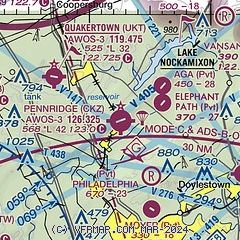
|
| Airport distance calculator |
|---|
|
|
| Sunrise and sunset |
|---|
|
Times for 07-Jul-2026
| | Local
(UTC-4) | | Zulu
(UTC) |
|---|
| Morning civil twilight | | 05:06 | | 09:06 |
| Sunrise | | 05:39 | | 09:39 |
| Sunset | | 20:33 | | 00:33 |
| Evening civil twilight | | 21:06 | | 01:06 |
|
| Current date and time |
|---|
| Zulu (UTC) | 07-Jul-2026 18:53:20 |
|---|
| Local (UTC-4) | 07-Jul-2026 14:53:20 |
|---|
|
| METAR |
|---|
| KCKZ | 071835Z AUTO 05004KT 10SM OVC015 22/21 A3004 RMK AO2
|
KUKT
5nm NW | 071835Z AUTO 02004KT 10SM 23/20 A3004 RMK AO2
|
KDYL
9nm SE | 071831Z AUTO VRB04KT 10SM OVC016 23/18 A3002 RMK AO2 T02280183 $
|
KXLL
14nm NW | 071835Z AUTO 00000KT 10SM OVC021 23/18 A3004 RMK AO2 TSNO
|
KPTW
15nm SW | 071754Z AUTO 32003KT OVC016 22/19 A3005 RMK AO2 SLP173 T02220189 10222 20183 58003 PWINO $
|
KLOM
15nm S | 071835Z AUTO 03004KT 10SM OVC016 23/19 A3003 RMK AO2 T02280193
|
KABE
17nm NW | 071751Z 04006KT 10SM OVC020 23/18 A3004 RMK AO2 SLP172 T02280178 10228 20183 56007 $
|
|
| TAF |
|---|
KABE
17nm NW | 071724Z 0718/0818 06007KT P6SM OVC015 FM080400 04004KT 6SM BR BKN010 FM081100 07004KT P6SM BKN020
|
|
| NOTAMs |
|---|
NOTAMs are issued by the DoD/FAA and will open in a separate window not controlled by AirNav.
|
|

