FAA INFORMATION EFFECTIVE 27 NOVEMBER 2025
Location
| FAA Identifier: | N85 |
| Lat/Long: | 40-35-15.2660N 075-01-09.9140W
40-35.254433N 075-01.165233W
40.5875739,-75.0194206
(estimated) |
| Elevation: | 480 ft. / 146.3 m (surveyed) |
| Variation: | 10W (1965) |
| From city: | 2 miles W of PITTSTOWN, NJ |
| Time zone: | UTC -5 (UTC -4 during Daylight Saving Time) |
| Zip code: | 08848 |
Airport Operations
| Airport use: | Open to the public |
| Activation date: | 09/1945 |
| Control tower: | no |
| ARTCC: | NEW YORK CENTER |
| FSS: | MILLVILLE FLIGHT SERVICE STATION |
| NOTAMs facility: | MIV (NOTAM-D service available) |
| Attendance: | 0800-DUSK |
| Wind indicator: | lighted |
| Segmented circle: | no |
| Lights: | ACTVT MIRL RY 08/26 - 121.8. |
| Beacon: | white-green (lighted land airport)
ACTIVATE ROTG BCN - 121.8. |
Airport Communications
| CTAF/UNICOM: | 122.975 |
| ALLENTOWN APPROACH: | 119.65 ;3000 FT & BLW 124.45 ;ABV 3000 FT |
| ALLENTOWN DEPARTURE: | 119.65 ;3000 FT & BLW 124.45 ;ABV 3000 FT |
| IC: | 119.65 ;3000 FT & BLW 124.45 ;ABV 3000 FT |
| WX AWOS-3 at N40 (2.2 nm SE): | 121.725 |
| WX ASOS at DYL (16 nm S): | 118.875 (215-345-0392) |
| WX ASOS at SMQ (16 nm E): | 120.6 (908-722-2139) |
| WX AWOS-3 at CKZ (17 nm SW): | 126.325 (215-257-7291) |
| WX AWOS-3 at UKT (19 nm SW): | 119.475 (215-538-7610) |
| WX ASOS at ABE (20 nm W): | 126.975 (610-477-0813) |
Nearby radio navigation aids
| VOR radial/distance | | VOR name | | Freq | | Var |
|---|
| SBJr281/12.7 | | SOLBERG VOR/DME | | 112.90 | | 10W |
| BWZr226/15.5 | | BROADWAY VOR/DME | | 114.20 | | 11W |
| ARDr356/20.7 | | YARDLEY VOR/DME | | 108.20 | | 10W |
| FJCr123/21.5 | | ALLENTOWN VORTAC | | 117.50 | | 10W |
| STWr207/25.4 | | STILLWATER VOR/DME | | 109.60 | | 11W |
| ETXr098/30.3 | | EAST TEXAS VOR/DME | | 110.20 | | 09W |
| PTWr057/33.0 | | POTTSTOWN VORTAC | | 116.50 | | 09W |
| RBVr324/33.3 | | ROBBINSVILLE VORTAC | | 113.80 | | 10W |
| SAXr228/36.1 | | SPARTA VORTAC | | 115.70 | | 11W |
| GXUr343/39.7 | | MC GUIRE VORTAC | | 110.60 | | 12W |
Airport Services
| Fuel available: | 100LL
100LL:24 HR SELF-SERVICE |
| Parking: | hangars and tiedowns |
| Airframe service: | MAJOR |
| Powerplant service: | MAJOR |
| Bottled oxygen: | NONE |
| Bulk oxygen: | NONE |
Runway Information
Runway 8/26
| Dimensions: | 2550 x 60 ft. / 777 x 18 m |
| Surface: | asphalt, in good condition |
| Runway edge lights: | medium intensity |
| RUNWAY 8 | | RUNWAY 26 |
| Latitude: | 40-35.141883N | | 40-35.322867N |
| Longitude: | 075-01.407300W | | 075-00.910250W |
| Elevation: | 463.0 ft. | | 480.0 ft. |
| Traffic pattern: | left | | left |
| Runway heading: | 074 magnetic, 064 true | | 254 magnetic, 244 true |
| Markings: | nonprecision, in good condition | | nonprecision, in good condition |
| Visual slope indicator: | 2-light PAPI on right (4.00 degrees glide path) | | 2-light PAPI on left (3.75 degrees glide path)
PAPI UNUSBL BYD 2 DEGS LEFT OF CNTRLN. |
| Touchdown point: | yes, no lights | | yes, no lights |
| Obstructions: | 50 ft. tree, 481 ft. from runway, 102 ft. left of centerline, 5:1 slope to clear | | 71 ft. tree, 232 ft. from runway, 208 ft. left of centerline
+33 FT TREE, 58 FT FM RWY END, 108 FT L. |
Runway 13/31
| Dimensions: | 1804 x 100 ft. / 550 x 30 m |
| Surface: | asphalt/turf, in good condition
25 FT WIDE ASPH STRIP FULL LENGTH DOWN CENTER OF RWY. TURF PORTION OF RWY UNUSABLE. |
| RUNWAY 13 | | RUNWAY 31 |
| Latitude: | 40-35.352633N | | 40-35.215417N |
| Longitude: | 075-01.345033W | | 075-00.999450W |
| Elevation: | 444.0 ft. | | 458.7 ft. |
| Traffic pattern: | left | | left |
| Runway heading: | 128 magnetic, 118 true | | 308 magnetic, 298 true |
| Markings: | numbers only, in fair condition | | numbers only, in fair condition |
| Touchdown point: | yes, no lights | | yes, no lights |
| Obstructions: | 16 ft. tree, 433 ft. from runway, 95 ft. left of centerline, 14:1 slope to clear | | 64 ft. tree, 666 ft. from runway, 142 ft. left of centerline, 7:1 slope to clear
+47 FT TREE, 112 FT FM RWY END, 117 FT L. |
Airport Ownership and Management from official FAA records
| Ownership: | Privately-owned |
| Owner: | ALEXANDRIA FIELD OF NEW JERSEY, LLC
15 AIRPORT ROAD
PITTSTOWN, NJ 08867
Phone 908-399-1820 |
| Manager: | TOM HEIMGARTNER
15 AIRPORT ROAD
PITTSTOWN, NJ 08867
Phone 908-399-1820 |
Additional Remarks
| - | TAXI ON PAVEMENT ONLY. |
| - | HEL TKOF AND LDGS RSTRD TO RWY 08/26 ONLY. |
| - | HEL USE FIXED-WING TFC PAT AND ALTS. |
| - | CTC ARPT MGR 908-730-9223 PRIOR TO CONDUCTING HEL TRNG ACT. |
| - | NO TGL OR STA ALLOWED. |
| - | FOR CD CTC ALLENTOWN APCH AT 800-728-6322. |
Instrument Procedures
NOTE: All procedures below are presented as PDF files. If you need a reader for these files, you should download the free Adobe Reader.NOT FOR NAVIGATION. Please procure official charts for flight.
FAA instrument procedures published for use from 27 November 2025 at 0901Z to 25 December 2025 at 0900Z.
IAPs - Instrument Approach Procedures |
|---|
| RNAV (GPS)-A | |
download (214KB) |
| RNAV (GPS)-B | |
download (195KB) |
| VOR/DME RWY 08 | |
download (178KB) |
| NOTE: Special Take-Off Minimums/Departure Procedures apply | |
download (437KB) |
Other nearby airports with instrument procedures:
N40 - Sky Manor Airport (2 nm SE)
N51 - Solberg/Hunterdon Airport (13 nm E)
N43 - Braden Airpark (14 nm NW)
KDYL - Doylestown Airport (16 nm S)
KSMQ - Somerset Airport (16 nm E)
KCKZ - Pennridge Airport (17 nm SW)
KUKT - Quakertown Airport (19 nm SW)
KABE - Lehigh Valley International Airport (20 nm W)
47N - Central Jersey Regional Airport (20 nm E)
39N - Princeton Airport (20 nm SE)
|
|

Road maps at:
MapQuest
Bing
Google
| Aerial photo |
|---|
WARNING: Photo may not be current or correct
 Taken in the Fall of 2011
looking southwest.
Taken in the Fall of 2011
looking southwest.
Do you have a better or more recent aerial photo of Alexandria Airport that you would like to share? If so, please send us your photo.
|
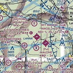
| Sectional chart |
|---|
|
CAUTION: Diagram may not be current

| Airport distance calculator |
|---|
|
|
| Sunrise and sunset |
|---|
|
Times for 17-Dec-2025
| | Local
(UTC-5) | | Zulu
(UTC) |
|---|
| Morning civil twilight | | 06:48 | | 11:48 |
| Sunrise | | 07:19 | | 12:19 |
| Sunset | | 16:33 | | 21:33 |
| Evening civil twilight | | 17:04 | | 22:04 |
|
| Current date and time |
|---|
| Zulu (UTC) | 17-Dec-2025 06:32:47 |
|---|
| Local (UTC-5) | 17-Dec-2025 01:32:47 |
|---|
|
| METAR |
|---|
KDYL
16nm S | 170554Z AUTO 21004KT 10SM CLR M06/M11 A3011 RMK AO2 SLP205 T10611111 11028 21067 58011 $
|
KSMQ
16nm E | ASOS 120.60 908-722-2139
170553Z AUTO 00000KT 9SM CLR M11/M13 A3011 RMK AO2 SLP200 T11061128 11056 21106 58012 $
|
KCKZ
17nm SW | 170615Z AUTO 00000KT 10SM FEW044 M06/M12 A3010 RMK AO2
|
KUKT
19nm SW | 170615Z AUTO 00000KT 10SM CLR M12/M13 A3009 RMK AO2
|
KABE
20nm W | 170551Z 00000KT 10SM CLR M09/M12 A3010 RMK AO2 SLP199 T10891117 11039 21106 58014 $
|
KTTN
20nm SE | ASOS 133.70 609-538-8690
170553Z AUTO 23003KT 10SM CLR M04/M11 A3012 RMK AO2 SLP196 T10441106 11028 21061 58012
|
KXLL
21nm W | 170615Z AUTO 00000KT 10SM CLR M06/M11 A3010 RMK AO2 TSNO
|
K12N
29nm NE | 170554Z AUTO 00000KT M09/M12 A3008 RMK AO1 SLP200 T10941117 11044 21094 58013 $
|
KLOM
29nm SW | 170615Z AUTO 00000KT 10SM CLR M09/M11 A3012 RMK AO2 T10931112
|
KMMU
30nm NE | 170615Z AUTO 00000KT 10SM CLR M09/M12 A3011 RMK AO2
|
|
| TAF |
|---|
KABE
20nm W | 170629Z 1706/1806 VRB03KT P6SM OVC040 FM171200 25010KT P6SM SCT080 BKN250 WS020/25040KT FM171600 26012G20KT P6SM BKN250 FM180000 26003KT P6SM SCT250
|
KTTN
20nm SE | 170520Z 1706/1806 VRB03KT P6SM BKN250 FM171000 VRB03KT P6SM SCT050 BKN100 FM171200 22010KT P6SM BKN250 FM171600 25010G18KT P6SM BKN250 FM180000 28003KT P6SM SCT250
|
|
| NOTAMs |
|---|
NOTAMs are issued by the DoD/FAA and will open in a separate window not controlled by AirNav.
|
|


