FAA INFORMATION EFFECTIVE 27 NOVEMBER 2025
Location
| FAA Identifier: | 1M9 |
| Lat/Long: | 36-49-04.0850N 087-54-27.0600W
36-49.068083N 087-54.451000W
36.8178014,-87.9075167
(estimated) |
| Elevation: | 570.9 ft. / 174.0 m (surveyed) |
| Variation: | 00E (1985) |
| From city: | 4 miles SW of CADIZ, KY |
| Time zone: | UTC -6 (UTC -5 during Daylight Saving Time) |
| Zip code: | 42211 |
Airport Operations
| Airport use: | Open to the public |
| Activation date: | 08/1980 |
| Control tower: | no |
| ARTCC: | MEMPHIS CENTER |
| FSS: | LOUISVILLE FLIGHT SERVICE STATION |
| NOTAMs facility: | LOU (NOTAM-D service available) |
| Attendance: | UNATNDD |
| Wind indicator: | lighted |
| Segmented circle: | yes |
| Lights: | ACTVT REIL RWY 02 & 20; PAPI RWY 20; MIRL RWY 02/20 - CTAF. |
| Beacon: | white-green (lighted land airport)
Operates sunset to sunrise. |
Airport Communications
Nearby radio navigation aids
| VOR radial/distance | | VOR name | | Freq | | Var |
|---|
| CKVr297/26.5 | | CLARKSVILLE VOR/DME | | 110.60 | | 01W |
Airport Services
Runway Information
Runway 2/20
| Dimensions: | 4800 x 75 ft. / 1463 x 23 m |
| Surface: | asphalt, in good condition |
| Weight bearing capacity: | |
| Runway edge lights: | medium intensity |
| RUNWAY 2 | | RUNWAY 20 |
| Latitude: | 36-48.697500N | | 36-49.438667N |
| Longitude: | 087-54.622333W | | 087-54.279667W |
| Elevation: | 549.0 ft. | | 570.9 ft. |
| Traffic pattern: | left | | left |
| Declared distances: | TORA:4800 TODA:4800 ASDA:4700 LDA:4600 | | TORA:4800 TODA:4800 ASDA:4700 LDA:4600 |
| Markings: | nonprecision, in good condition | | nonprecision, in good condition |
| Visual slope indicator: | | | 2-light PAPI on left (4.00 degrees glide path) |
| Runway end identifier lights: | yes | | yes |
| Touchdown point: | yes, no lights | | yes, no lights |
| Obstructions: | 31 ft. trees, 202 ft. from runway, 74 ft. right of centerline
TREE 198 FT FM END OF RWY, 128 FT L OF RWY END. TREES 82 FT - 191 FT FM RWY END, 165 FT-237 FT R OF RWY END. | | 25 ft. trees, 216 ft. from runway, 234 ft. left of centerline
TREE 198 FT FM END OF RWY, 237 FT L OF RWY END. TREES 33 FT - 178 FT FM RWY END, 143 FT- 171 FT R OF RWY END. |
Airport Ownership and Management from official FAA records
| Ownership: | Publicly-owned |
| Owner: | KY DEPT OF PARKS
500 MERO STREET, 5TH FLOOR
FRANKFORT, KY 40601
Phone (502) 892-3367 |
| Manager: | ASHLEY JOINER
3500 STATE PARK ROAD
CADIZ, KY 42211
Phone 270-924-1131 |
Additional Remarks
| - | PARK LODGE T/R - 270-924-1131 |
| - | DEER & BIRDS ON & INVOF ARPT. |
| - | FOR CD CTC CAMPBELL APCH AT 270-798-6441. |
Instrument Procedures
There are no published instrument procedures at 1M9.
Some nearby airports with instrument procedures:
2M0 - Princeton-Caldwell County Airport (18 nm N)
KHOP - Campbell Army Airfield (Fort Campbell) (22 nm SE)
KHVC - Hopkinsville-Christian County Airport (22 nm E)
M34 - Kentucky Dam State Park Airport (22 nm NW)
KCEY - Kyle-Oakley Field Airport (24 nm W)
|
|

Road maps at:
MapQuest
Bing
Google
| Aerial photo |
|---|
WARNING: Photo may not be current or correct
 Photo taken 03-Mar-2018
looking northeast.
Do you have a better or more recent aerial photo of Lake Barkley State Park Airport that you would like to share? If so, please send us your photo.
|
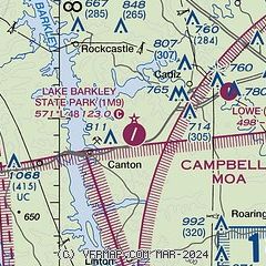
| Sectional chart |
|---|

|
| Airport distance calculator |
|---|
|
|
| Sunrise and sunset |
|---|
|
Times for 16-Dec-2025
| | Local
(UTC-6) | | Zulu
(UTC) |
|---|
| Morning civil twilight | | 06:30 | | 12:30 |
| Sunrise | | 06:59 | | 12:59 |
| Sunset | | 16:36 | | 22:36 |
| Evening civil twilight | | 17:05 | | 23:05 |
|
| Current date and time |
|---|
| Zulu (UTC) | 16-Dec-2025 10:03:43 |
|---|
| Local (UTC-6) | 16-Dec-2025 04:03:43 |
|---|
|
| METAR |
|---|
KHOP
22nm SE | 160955Z AUTO 19006KT 10SM OVC035 M00/M12 A3020 RMK AO2 SLP233 T10031117 $
|
KHVC
22nm E | 160955Z AUTO 00000KT 10SM OVC038 M01/M10 A3021 RMK AO2
|
KCEY
24nm W | 160955Z AUTO 22006G12KT 10SM BKN037 M00/M12 A3021 RMK AO2
|
KEOD
25nm SE | 160955Z AUTO 21005KT 10SM BKN035 M01/M10 A3023 RMK AO2 SLP245 T10101096
|
KCKV
27nm SE | 160952Z AUTO 18004KT 10SM OVC035 00/M09 A3022 RMK AO2 SLP238 T00001094
|
KGDA
33nm N | 160955Z AUTO 21003KT 10SM OVC029 00/M12 A3019 RMK AO2 T10021119
|
KM25
33nm W | 160955Z AUTO 21008KT 10SM OVC028 00/M11 A3020 RMK AO2 T00011109 $
|
KPHT
37nm SW | 160950Z AUTO 20007KT 10SM OVC034 M00/M10 A3020 RMK A01
|
K2I0
40nm NE | 160955Z AUTO 23009KT 10SM OVC032 01/M12 A3020 RMK AO2 T00121125
|
|
| TAF |
|---|
KHOP
22nm SE | 160000Z 1600/1706 VRB06KT 9999 SKC QNH3023INS BECMG 1608/1609 21012KT 9999 BKN030 QNH3008INS TX09/1620Z TNM04/1609Z
|
KCKV
27nm SE | 160520Z 1606/1706 20007KT P6SM SKC
|
|
| NOTAMs |
|---|
NOTAMs are issued by the DoD/FAA and will open in a separate window not controlled by AirNav.
|
|


