FAA INFORMATION EFFECTIVE 14 MAY 2026
Location
| FAA Identifier: | 2N6 |
| Lat/Long: | 40-01-37.5000N 074-41-27.2000W
40-01.625000N 074-41.453333W
40.0270833,-74.6908889
(estimated) |
| Elevation: | 78 ft. / 24 m (estimated) |
| Variation: | 12W (1985) |
| From city: | 1 mile S of JOBSTOWN, NJ |
| Time zone: | UTC -4 (UTC -5 during Standard Time) |
| Zip code: | 08041 |
Airport Operations
| Airport use: | Open to the public |
| Activation date: | 03/1960 |
| Control tower: | no |
| ARTCC: | NEW YORK CENTER |
| FSS: | MILLVILLE FLIGHT SERVICE STATION |
| NOTAMs facility: | MIV (NOTAM-D service available) |
| Attendance: | IREG |
| Wind indicator: | yes |
| Segmented circle: | no |
Airport Communications
| CTAF: | 122.9 |
| WX ASOS at VAY (9 nm SW): | 119.325 (609-267-1176) |
| WX ASOS at PNE (15 nm W): | PHONE 215-897-9068 |
| WX ASOS at TTN (16 nm N): | 126.775 (609-538-8690) |
| WX AWOS-3PT at MJX (19 nm E): | 119.875 (732-797-2542) |
Nearby radio navigation aids
| VOR radial/distance | | VOR name | | Freq | | Var |
|---|
| GXUr296/4.5 | | MC GUIRE VORTAC | | 110.60 | | 12W |
| RBVr231/13.8 | | ROBBINSVILLE VORTAC | | 113.80 | | 10W |
| ARDr154/16.8 | | YARDLEY VOR/DME | | 108.20 | | 10W |
| CYNr327/17.3 | | COYLE VORTAC | | 113.40 | | 10W |
| COLr246/29.7 | | COLTS NECK VOR/DME | | 115.40 | | 11W |
| VCNr033/32.0 | | CEDAR LAKE VOR/DME | | 115.20 | | 10W |
| SBJr186/33.4 | | SOLBERG VOR/DME | | 112.90 | | 10W |
| ACYr001/34.7 | | ATLANTIC CITY VORTAC | | 117.15 | | 10W |
| OODr060/36.7 | | WOODSTOWN VORTAC | | 112.80 | | 10W |
| NDB name | | Hdg/Dist | | Freq | | Var | | ID |
|---|
| LAKEHURST | | 277/16.4 | | 396 | | 11W | | NEL | -. . .-.. |
Airport Services
| Parking: | tiedowns |
| Airframe service: | NONE |
| Powerplant service: | NONE |
| Bottled oxygen: | NONE |
| Bulk oxygen: | NONE |
Runway Information
Runway 6/24
| Dimensions: | 1830 x 50 ft. / 558 x 15 m |
| Surface: | turf, in fair condition |
| RUNWAY 6 | | RUNWAY 24 |
| Traffic pattern: | left | | left |
| Obstructions: | 56 ft. trees, 725 ft. from runway, 155 ft. left of centerline, 12:1 slope to clear
RY 06 FIRST HALF, TREES WITHIN 90 FT OF CTLN. | | 15 ft. road
RWY 24 ADDTNL OBSTRS, +35 TO +62 FT TREES, DIST 320-400 FT, 80-120 FT L. |
Runway 11/29
| Dimensions: | 1590 x 70 ft. / 485 x 21 m |
| Surface: | turf, in fair condition |
| Runway edge lights: | non-standard
LGTS INOP. |
| RUNWAY 11 | | RUNWAY 29 |
| Latitude: | 40-01.645168N | | 40-01.606395N |
| Longitude: | 074-41.622142W | | 074-41.285158W |
| Elevation: | 73.0 ft. | | 78.0 ft. |
| Traffic pattern: | right | | left |
| Runway heading: | 111 magnetic, 099 true | | 291 magnetic, 279 true |
| Obstructions: | 38 ft. trees, 10 ft. from runway, 100 ft. left of centerline | | 63 ft. tree, 1500 ft. from runway, 23:1 slope to clear |
Airport Ownership and Management from official FAA records
| Ownership: | Privately-owned |
| Owner: | CENTRAL JERSEY R.W. INC
2 MALONE ROAD
TABERNACLE, NJ 08088
Phone 609-915-1280 |
| Manager: | ERIKA PEARSON
2 MALONE ROAD
TABERNACLE, NJ 08088
Phone 609-915-1280 |
Additional Remarks
| - | NSTD LTG RWY 11/29 OTS INDEFLY. |
| - | FOR CD CTC MC GUIRE APCH AT 609-754-2767. |
| - | DEER & BIRDS ON & INVOF ARPT. |
| - | TSNT ACFT CALL AMGR OR 609-915-8281 FOR ACES. |
Instrument Procedures
There are no published instrument procedures at 2N6.
Some nearby airports with instrument procedures:
KWRI - McGuire Field (Joint Base Mc Guire Dix Lakehurst) Airport (5 nm E)
N14 - Flying W Airport (8 nm SW)
KVAY - South Jersey Regional Airport (9 nm SW)
N87 - Trenton-Robbinsville Airport (12 nm N)
KPNE - Northeast Philadelphia Airport (15 nm W)
KNEL - Lakehurst Maxfield Field Airport (16 nm E)
KTTN - Trenton Mercer Airport (16 nm N)
19N - Pine Valley Airport (19 nm SW)
KMJX - Ocean County Airport (19 nm E)
|
|

Road maps at:
MapQuest
Bing
Google
| Aerial photo |
|---|
WARNING: Photo may not be current or correct
 Looking north.
Do you have a better or more recent aerial photo of Redwing Airport that you would like to share? If so, please send us your photo.
|
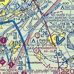
| Sectional chart |
|---|
|
| Airport distance calculator |
|---|
|
|
| Sunrise and sunset |
|---|
|
Times for 08-Jun-2026
| | Local
(UTC-4) | | Zulu
(UTC) |
|---|
| Morning civil twilight | | 04:58 | | 08:58 |
| Sunrise | | 05:31 | | 09:31 |
| Sunset | | 20:25 | | 00:25 |
| Evening civil twilight | | 20:57 | | 00:57 |
|
| Current date and time |
|---|
| Zulu (UTC) | 09-Jun-2026 02:41:23 |
|---|
| Local (UTC-4) | 08-Jun-2026 22:41:23 |
|---|
|
| METAR |
|---|
KWRI
5nm E | 090155Z AUTO 18004KT 10SM CLR 14/08 A3029 RMK AO2 SLP256 T01440077 $
|
KVAY
9nm SW | ASOS 119.325 609-267-1176
090154Z AUTO A3030 RMK AO2 SLPNO PWINO $
|
KPNE
15nm W | 090154Z VRB03KT 10SM CLR 19/06 A3031 RMK AO2 SLP262 T01890061 $
|
KTTN
16nm N | ASOS 133.70 609-538-8690
090153Z 19004KT 10SM CLR 17/07 A3028 RMK AO2 SLP247 T01670067
|
KMJX
19nm E | AWOS-3 119.875 732-244-4450
090156Z AUTO 00000KT 10SM CLR 12/07 A3030 RMK AO2 SLP265 T01220067 $
|
|
| TAF |
|---|
KWRI
5nm E | 090200Z 0902/1008 VRB06KT 9999 FEW200 QNH3029INS BECMG 0917/0918 17010G15KT 9999 SCT050 BKN200 QNH3013INS BECMG 1005/1006 VRB05KT 9999 BKN040 OVC120 QNH3009INS TX27/0918Z TN09/0909Z
|
KPNE
15nm W | 081720Z 0818/0918 10007KT P6SM SCT045 FM082200 13009KT P6SM SKC FM090200 16005KT P6SM SKC FM090400 VRB03KT P6SM FEW250 FM091500 21007KT P6SM FEW190
|
KTTN
16nm N | 082156Z 0822/0918 19012KT P6SM SKC FM090000 15008KT P6SM SKC FM090200 VRB04KT P6SM FEW250 FM091400 21007KT P6SM FEW190
|
|
| NOTAMs |
|---|
NOTAMs are issued by the DoD/FAA and will open in a separate window not controlled by AirNav.
|
|

