FAA INFORMATION EFFECTIVE 15 MAY 2025
Location
| FAA Identifier: | AAO |
| Lat/Long: | 37-44-51.2670N 097-13-16.0240W
37-44.854450N 097-13.267067W
37.7475742,-97.2211178
(estimated) |
| Elevation: | 1420.8 ft. / 433.1 m (surveyed) |
| Variation: | 06E (2000) |
| From city: | 9 miles NE of WICHITA, KS |
| Time zone: | UTC -5 (UTC -6 during Standard Time) |
| Zip code: | 67226 |
Airport Operations
| Airport use: | Open to the public |
| Activation date: | 07/1944 |
| Control tower: | no |
| ARTCC: | KANSAS CITY CENTER |
| FSS: | WICHITA FLIGHT SERVICE STATION |
| NOTAMs facility: | AAO (NOTAM-D service available) |
| Attendance: | CONTINUOUS |
| Wind indicator: | lighted |
| Segmented circle: | yes |
| Lights: | APT LGT SKED: ACTVT MIRL RY 18/36, MALSR RY 18, REIL RY 36 - CTAF. PAPI RYS 18 & 36 OPR CONT. |
| Beacon: | white-green (lighted land airport)
Operates sunset to sunrise. |
Airport Communications
| CTAF/UNICOM: | 122.7 |
| WX ASOS: | 134.025 (316-636-2541) |
| WICHITA APPROACH: | 134.8 |
| WICHITA DEPARTURE: | 134.8 |
| CLEARANCE DELIVERY: | 125.0 |
| WX AWOS-3PT at BEC (3 nm S): | 119.45 (316-515-7116) |
| WX AWOS-2 at 1K1 (5 nm E): | 118.3 (316-530-6004) |
| WX AWOS-3P at 3AU (8 nm SE): | 124.175 (316-733-6696) |
| WX ASOS at ICT (12 nm SW): | PHONE 316-800-1006 |
| WX AWOS-3PT at EWK (19 nm N): | 123.875 (316-283-8789) |
| WX AWOS-3P at EQA (19 nm E): | 120.875 (316-322-8095) |
Nearby radio navigation aids
| VOR radial/distance | | VOR name | | Freq | | Var |
|---|
| ICTr083/17.2 | | WICHITA VORTAC | | 113.80 | | 07E |
| HUTr110/36.9 | | HUTCHINSON VOR/DME | | 116.80 | | 04E |
Airport Services
| Fuel available: | 100LL JET-A
100LL:FOR 24 HOUR FUEL CONTACT FBO |
| Parking: | hangars and tiedowns |
| Airframe service: | MAJOR |
| Powerplant service: | MAJOR |
| Bottled oxygen: | NONE |
| Bulk oxygen: | NONE |
Runway Information
Runway 18/36
| Dimensions: | 6101 x 100 ft. / 1860 x 30 m |
| Surface: | concrete/grooved, in good condition |
| Weight bearing capacity: | | PCN 15 /R/B/X/T | | Single wheel: | 40.0 | | Double wheel: | 62.0 |
|
| Runway edge lights: | medium intensity |
| RUNWAY 18 | | RUNWAY 36 |
| Latitude: | 37-45.353470N | | 37-44.355437N |
| Longitude: | 097-13.191685W | | 097-13.342427W |
| Elevation: | 1401.2 ft. | | 1420.8 ft. |
| Traffic pattern: | right | | left |
| Runway heading: | 181 magnetic, 187 true | | 001 magnetic, 007 true |
| Markings: | precision, in good condition | | nonprecision, in good condition |
| Visual slope indicator: | 4-light PAPI on left (3.00 degrees glide path) | | 4-light PAPI on left (3.00 degrees glide path) |
| Approach lights: | MALSR: 1,400 foot medium intensity approach lighting system with runway alignment indicator lights | | |
| Runway end identifier lights: | no | | yes |
| Touchdown point: | yes, no lights | | yes, no lights |
| Instrument approach: | ILS/DME | | |
Airport Ownership and Management from official FAA records
| Ownership: | Publicly-owned |
| Owner: | WICHITA AIRPORT AUTHORITY
2173 AIR CARGO RD
WICHITA, KS 67209
Phone 316-946-4700 |
| Manager: | MR. JESSE R ROMO, A.A.E.
2173 AIR CARGO ROAD
WICHITA, KS 67209
Phone 316-946-4700 |
Additional Remarks
| - | ATTENDED CONTINUOUSLY. |
| - | USE CTN FOR MCCONNELL AFB 9 MILES S AND BEECH FACTORY ARPT 3 MILES S. |
| - | BEECH FACTORY ARPT CLASS D ASP BEGINS 1 MILE S RWY 18. |
| - | SOUTHERLY AND SOUTHEASTERLY VFR ARR AND DEP NOT RCMDD WO ATC RADAR SVCS DUE TO BEECH FACTORY ARPT AND MCCONNELL AFB CLASS D AFB ASP. |
| - | VFR ARR AND DEP RECOMMENDED TO RMN AT OR BLW 2,500 MSL WITHIN 5 MILES DUE TO HEAVY MIL TFC 3,000 MSL. |
| - | DUE TO 20 RWY END ELEV DIFFERENTIAL, PILOTS MAY LOSE LINE OF SIGHT OF OTR ACFT ON OPPOSING RWY ENDS. |
| - | RWY 18 NSTD TFC PAT. |
| - | ALL TFC PATS W OF FLD. |
| - | RWY 36 DSGND CALM WIND RWY. |
| - | ACFT ENGINE RUNS ABOVE IDLE NOT APPROVED ON ACFT PRKG RAMPS. |
| - | PPR FOR ACFT CARRYING CLASS 1?DIVISION 1.1, 1.2 OR 1.3 EXPLOSIVES AS DEFINED BY 49 CFR 173.50 OR AS AMENDED. |
| - | MIGRATORY BIRDS ON AND IN VCNTY OF ARPT, ALL QUADS. |
Instrument Procedures
NOTE: All procedures below are presented as PDF files. If you need a reader for these files, you should download the free Adobe Reader.NOT FOR NAVIGATION. Please procure official charts for flight.
FAA instrument procedures published for use from 15 May 2025 at 0901Z to 13 June 2025 at 0900z.
IAPs - Instrument Approach Procedures |
|---|
| ILS OR LOC RWY 18 | |
download (232KB) |
| RNAV (GPS) RWY 18 | |
download (244KB) |
| RNAV (GPS) RWY 36 | |
download (253KB) |
| RNAV (GPS)-E | |
download (190KB) |
| NOTE: Special Alternate Minimums apply | |
download (140KB) |
| NOTE: Special Take-Off Minimums/Departure Procedures apply | |
download (147KB) |
Other nearby airports with instrument procedures:
KBEC - Beech Factory Airport (3 nm S)
1K1 - Lloyd Stearman Field Airport (5 nm E)
KCEA - Cessna Aircraft Field Airport (6 nm S)
KIAB - Mc Connell Air Force Base (8 nm S)
3AU - Augusta Municipal Airport (8 nm SE)
K50 - Cook Airfield (11 nm S)
KICT - Wichita Dwight D Eisenhower National Airport (12 nm SW)
KEWK - Newton City/County Airport (19 nm N)
KEQA - El Dorado/Capt Jack Thomas Memorial Airport (19 nm E)
|
|

Road maps at:
MapQuest
Bing
Google
| Aerial photo |
|---|
WARNING: Photo may not be current or correct
 Photo by Matthew Bell
Photo taken 19-Feb-2013
looking south.
Photo by Matthew Bell
Photo taken 19-Feb-2013
looking south.
Do you have a better or more recent aerial photo of Colonel James Jabara Airport that you would like to share? If so, please send us your photo.
|
| Sectional chart |
|---|
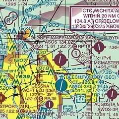
|
| Airport distance calculator |
|---|
|
|
| Sunrise and sunset |
|---|
|
Times for 18-May-2025
| | Local
(UTC-5) | | Zulu
(UTC) |
|---|
| Morning civil twilight | | 05:48 | | 10:48 |
| Sunrise | | 06:18 | | 11:18 |
| Sunset | | 20:33 | | 01:33 |
| Evening civil twilight | | 21:03 | | 02:03 |
|
| Current date and time |
|---|
| Zulu (UTC) | 19-May-2025 00:55:27 |
|---|
| Local (UTC-5) | 18-May-2025 19:55:27 |
|---|
|
| METAR |
|---|
| KAAO | 182354Z AUTO 14020G35KT 10SM OVC017 19/17 A2964 RMK AO2 PK WND 13035/2349 RAB06E25 SLP029 P0000 60000 T01890167 10250 20189 56019 $
|
KBEC
3nm S | 190035Z AUTO 13018G27KT 10SM OVC017 19/16 A2964 RMK AO2 LTG DSNT N AND E T01910161
|
KIAB
8nm S | 182355Z AUTO 16025G31KT 10SM OVC017 21/17 A2962 RMK AO2 PK WND 15038/18 CIG 016 RWY01 SLP024 60001 T02060166 10251 20201 57024
|
KICT
12nm SW | 182353Z 14020G37KT 10SM OVC018 20/16 A2961 RMK AO2 PK WND 12038/2256 SLP019 60007 T02000161 10239 20200 56024 $
|
KEWK
17nm N | 182356Z AUTO 12020G28KT 10SM OVC006 18/ A2965 RMK AO2 PK WND 15033/2311 LTG DSNT NE AND E TSE16 CIG 004V011 SLP029 P0001 60013 T0178 10256 20178 55014
|
KEQA
19nm E | 190035Z AUTO 13019G33KT 10SM SCT011 OVC027 19/18 A2965 RMK AO2
|
|
| TAF |
|---|
KIAB
8nm S | 182009Z 1820/1924 15025G35KT 9999 VCTS OVC020CB QNH2963INS TEMPO 1820/1822 VRB35G45KT 6000 TSRA OVC015CB BECMG 1821/1822 15025G35KT 9999 VCTS OVC020CB QNH2952INS TEMPO 1822/1906 VRB40G50KT 3200 TSRA OVC015CB BECMG 1906/1907 17025G35KT 9999 NSW OVC020 530002 530308 QNH2953INS BECMG 1911/1912 18015G25KT 9999 SCT030 520003 QNH2946INS BECMG 1919/1920 20012G18KT 9999 SKC QNH2943INS TX24/1821Z TN20/1912Z
|
KICT
12nm SW | 181734Z 1818/1918 14018G26KT P6SM SCT015 OVC025 TEMPO 1818/1821 -TSRA OVC025CB FM182100 14020G28KT P6SM SCT009 OVC015 PROB30 1900/1905 VRB20G40KT 2SM +TSRA OVC015CB
|
|
| NOTAMs |
|---|
NOTAMs are issued by the DoD/FAA and will open in a separate window not controlled by AirNav.
|
|


