FAA INFORMATION EFFECTIVE 22 JANUARY 2026
Location
| FAA Identifier: | MFV |
| Lat/Long: | 37-38-48.7640N 075-45-39.7630W
37-38.812733N 075-45.662717W
37.6468789,-75.7610453
(estimated) |
| Elevation: | 47.6 ft. / 14.5 m (surveyed) |
| Variation: | 11W (2000) |
| From city: | 1 mile W of MELFA, VA |
| Time zone: | UTC -5 (UTC -4 during Daylight Saving Time) |
| Zip code: | 23410 |
Airport Operations
| Airport use: | Open to the public |
| Activation date: | 11/1943 |
| Control tower: | no |
| ARTCC: | WASHINGTON CENTER |
| FSS: | LEESBURG FLIGHT SERVICE STATION |
| NOTAMs facility: | MFV (NOTAM-D service available) |
| Attendance: | 0830-1730
AFT HRS ACES TO RESTROOMS. |
| Pattern altitude: | TPA LGT ACFT 850 FT, HVY ACFT 1500 FT. |
| Wind indicator: | lighted |
| Segmented circle: | yes |
| Lights: | MIRL RWY 03/21 PRESET LOW INTST; INCR INTST & ACTVT REIL RWYS 03 & 21 - CTAF. |
| Beacon: | white-green (lighted land airport)
Operates sunset to sunrise. |
Airport Communications
| CTAF/UNICOM: | 122.8 |
| WX AWOS-3: | 118.175 (757-787-5660) |
| PATUXENT APPROACH: | 127.95 |
| POTOMAC APPROACH: | 127.2 ;WHEN NHK APCH CLSD |
| PATUXENT DEPARTURE: | 127.95 |
| POTOMAC DEPARTURE: | 127.2 ;WHEN NHK APCH CLSD |
| WX AWOS-3 at TGI (16 nm NW): | 119.8 (757-891-2246) |
- APCH/DEP SVC PRVDD BY POTOMAC TRACON ON 127.2/281.475 WHEN PATUXENT APCH CTL CLSD.
Nearby radio navigation aids
| VOR radial/distance | | VOR name | | Freq | | Var |
|---|
| CCVr042/21.2 | | CAPE CHARLES VORTAC | | 112.20 | | 10W |
Airport Services
| Fuel available: | 100LL JET-A
100LL:SELF-SERVE FUEL (100LL AND A) AVBL 24HRS. |
| Parking: | tiedowns |
| Airframe service: | NONE |
| Powerplant service: | NONE |
| Bottled oxygen: | NONE |
| Bulk oxygen: | NONE |
Runway Information
Runway 3/21
| Dimensions: | 5000 x 100 ft. / 1524 x 30 m |
| Surface: | asphalt, in excellent condition |
| Weight bearing capacity: | |
| Runway edge lights: | medium intensity |
| RUNWAY 3 | | RUNWAY 21 |
| Latitude: | 37-38.433472N | | 37-39.192005N |
| Longitude: | 075-45.864995W | | 075-45.460420W |
| Elevation: | 46.6 ft. | | 47.6 ft. |
| Traffic pattern: | left | | left |
| Runway heading: | 034 magnetic, 023 true | | 214 magnetic, 203 true |
| Markings: | nonprecision, in good condition | | nonprecision, in good condition |
| Visual slope indicator: | 2-light PAPI on left (3.00 degrees glide path) | | 2-light PAPI on left (3.00 degrees glide path) |
| Runway end identifier lights: | yes | | yes |
| Touchdown point: | yes, no lights | | yes, no lights |
| Instrument approach: | LOC/DME | | |
| Obstructions: | 74 ft. tree, 2570 ft. from runway, 229 ft. left of centerline, 32:1 slope to clear | | 94 ft. tree, 1747 ft. from runway, 318 ft. left of centerline, 16:1 slope to clear |
Airport Ownership and Management from official FAA records
| Ownership: | Publicly-owned |
| Owner: | COUNTY OF ACCOMACK
29194 PARKWAY NORTH
MELFA, VA 23410
Phone 757-787-4600 |
| Manager: | BRUCE HERBERT
29194 PARKWAY NORTH
MELFA, VA 23410
Phone 757-787-4600 |
Additional Remarks
| A25 | SUBJECT TO EXCLUSIVE RIGHTS PROHIBITION OF SECTION 308A (CONSTRUCTED BY BPR). |
| - | DEER ON & INVOF ARPT. |
| - | FOR CD CTC PATUXENT APCH AT 301-342-3740, WHEN PATUXENT APCH IS CLSD CTC POTOMAC APCH AT 866-640-4124. |
Instrument Procedures
NOTE: All procedures below are presented as PDF files. If you need a reader for these files, you should download the free Adobe Reader.NOT FOR NAVIGATION. Please procure official charts for flight.
FAA instrument procedures published for use from 22 January 2026 at 0901Z to 19 February 2026 at 0900z.
IAPs - Instrument Approach Procedures |
|---|
| RNAV (GPS) RWY 03 | |
download (202KB) |
| RNAV (GPS) RWY 21 | |
download (184KB) |
| LOC RWY 03 | |
download (197KB) |
| NOTE: Special Alternate Minimums apply | |
download (169KB) |
| NOTE: Special Take-Off Minimums/Departure Procedures apply | |
download (140KB) |
Other nearby airports with instrument procedures:
KTGI - Tangier Island Airport (16 nm NW)
KWAL - Wallops Flight Facility (22 nm NE)
W41 - Crisfield-Somerset County Airport (22 nm N)
W75 - Hummel Field Airport (33 nm W)
KSBY - Salisbury-Ocean City Wicomico Regional Airport (43 nm N)
|
|

Road maps at:
MapQuest
Bing
Google
| Aerial photo |
|---|
WARNING: Photo may not be current or correct
 Photo by David Newcomer
Photo taken 06-Sep-2010
looking south.
Photo by David Newcomer
Photo taken 06-Sep-2010
looking south.
Do you have a better or more recent aerial photo of Accomack County Airport that you would like to share? If so, please send us your photo.
|
| Sectional chart |
|---|
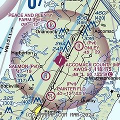
|
| Airport distance calculator |
|---|
|
|
| Sunrise and sunset |
|---|
|
Times for 03-Feb-2026
| | Local
(UTC-5) | | Zulu
(UTC) |
|---|
| Morning civil twilight | | 06:39 | | 11:39 |
| Sunrise | | 07:06 | | 12:06 |
| Sunset | | 17:28 | | 22:28 |
| Evening civil twilight | | 17:55 | | 22:55 |
|
| Current date and time |
|---|
| Zulu (UTC) | 03-Feb-2026 16:59:34 |
|---|
| Local (UTC-5) | 03-Feb-2026 11:59:34 |
|---|
|
| METAR |
|---|
| KMFV | 031655Z AUTO 30006KT 10SM CLR 03/M13 A3025 RMK AO2 T00281133
|
KTGI
16nm NW | 031635Z AUTO 31004KT 10SM CLR A3026 RMK AO1
|
|
| TAF |
|---|
KSBY
43nm N | 031120Z 0312/0412 VRB02KT P6SM SCT070 FM031400 28005KT P6SM SCT250 FM032000 25004KT P6SM BKN100 FM040500 VRB03KT 2SM -SN BR OVC015 FM041000 VRB03KT P6SM OVC007
|
KLFI
45nm SW | 021509Z 0218/0400 31012G18KT 9999 FEW250 QNH3020INS BECMG 0221/0222 28012KT 9999 FEW250 QNH3020INS BECMG 0309/0310 24009KT 9999 FEW030 FEW250 QNH3024INS TX04/0317Z TNM02/0312Z
|
KPHF
47nm SW | 031120Z 0312/0412 VRB03KT P6SM SKC FM031500 25007KT P6SM SCT250 FM032100 20004KT P6SM BKN100 FM040400 21003KT P6SM OVC050 FM040700 22004KT 5SM -RA BR OVC020 FM040900 24004KT 5SM -RA BR OVC010
|
KNHK
48nm NW | 0315/0415 VRB06KT 9999 FEW050 SCT250 QNH3017INS BECMG 0317/0318 12007KT 9999 SCT060 BKN250 QNH3015INS BECMG 0322/0323 12004KT 9999 BKN050 BKN250 QNH3014INS BECMG 0403/0405 VRB04KT 9999 VCSH BKN015 BKN040 QNH3013INS TEMPO 0407/0413 -SN OVC009 TX03/0320Z TNM03/0310Z FN20065
|
KORF
49nm SW | 031120Z 0312/0412 22004KT P6SM SKC FM031500 25007KT P6SM SCT250 FM032100 21004KT P6SM BKN100 FM040800 23004KT 5SM -RA BR OVC025 FM041100 26004KT 5SM -RA BR OVC012
|
|
| NOTAMs |
|---|
NOTAMs are issued by the DoD/FAA and will open in a separate window not controlled by AirNav.
|
|

