FAA INFORMATION EFFECTIVE 16 APRIL 2026
Location
| FAA Identifier: | MYF |
| Lat/Long: | 32-48-56.6000N 117-08-22.4000W
32-48.943333N 117-08.373333W
32.8157222,-117.1395556
(estimated) |
| Elevation: | 427.3 ft. / 130.2 m (surveyed) |
| Variation: | 14E (1980) |
| From city: | 6 miles N of SAN DIEGO, CA |
| Time zone: | UTC -7 (UTC -8 during Standard Time) |
| Zip code: | 92123 |
Airport Operations
| Airport use: | Open to the public |
| Activation date: | 07/1940 |
| Control tower: | yes |
| ARTCC: | LOS ANGELES CENTER |
| FSS: | SAN DIEGO FLIGHT SERVICE STATION |
| NOTAMs facility: | MYF (NOTAM-D service available) |
| Attendance: | M-S 0700-1800 |
| Pattern altitude: | TPA RWYS 10R/28L, 10L/28R, AND 05/23 - MULTI ENG/TURBO PWRD 1600 FT; SNGL ENG 1000 FT. |
| Wind indicator: | lighted |
| Segmented circle: | yes |
| Lights: | ATC CTL. WHEN ATCT CLSD ACTVT PAPI RWY 10L & 28R; MALSR RWY 28R - CTAF, MIRL RWY 10L/28R OPER CONSLY. |
| Beacon: | white-green (lighted land airport)
Operates sunset to sunrise. |
Airport Communications
| CTAF: | 119.2 |
| UNICOM: | 123.075 |
| ATIS: | 126.9 |
| WX ASOS: | 126.9 (858-576-4337) |
| MONTGOMERY GROUND: | 118.225 [0600-2100] |
| MONTGOMERY TOWER: | 119.2 ;ALL RYS, EXCEPT RY 28R BTW 1800-0200Z++ 125.7 ;RY 28R BTW 1800-0200Z++ 269.4 [0600-2100] |
| SOCAL APPROACH: | 124.35 |
| SOCAL DEPARTURE: | 119.6 |
| CLEARANCE DELIVERY: | 123.725 |
| CLASS B: | 119.6 ;225-293 SAN 17,000 FT & BLW 124.35 ;062-109 SAN 14,000 FT & BLW 132.2 ;029-061 SAN 14,000 FT & BLW 132.2 ;333-028 SAN 7,000 FT-11,000 F |
| CWARD DP: | 119.6 |
| PADRZ DP: | 119.6 |
| WX ASOS at SAN (6 nm SW): | PHONE 619-607-3429 |
| WX AWOS-3P at SEE (8 nm E): | 125.45 (619-449-1228) |
| WX ASOS at NRS (15 nm S): | PHONE 619-437-9890 |
| WX ASOS at SDM (17 nm SE): | 132.35 (619-333-1055) |
| WX ASOS at RNM (18 nm NE): | PHONE 760-239-7043 |
- FREQ 125.7 ALSO USED FOR TOUCH AND GO LANDINGS RWY 10L-28R.
- SAID IN USE. OPERATE TRANSPONDERS WITH ALTITUDE REPORTING MODE AND ADS-B (IF EQUIPPED) ENABLED ON ALL AIRPORT SURFACES.
Nearby radio navigation aids
| VOR radial/distance | | VOR name | | Freq | | Var |
|---|
| MZBr050/4.8 | | MISSION BAY VORTAC | | 117.80 | | 15E |
| PGYr313/14.7 | | POGGI VORTAC | | 116.45 | | 14E |
| TIJr318/19.0 | | TIJUANA VOR/DME | | 116.50 | | 12E |
| OCNr136/29.1 | | OCEANSIDE VORTAC | | 115.30 | | 15E |
| JLIr220/34.0 | | JULIAN VORTAC | | 113.75 | | 15E |
Airport Services
| Fuel available: | 100LL JET-A JET-A+ UL94 |
| Parking: | tiedowns |
| Airframe service: | MAJOR |
| Powerplant service: | MAJOR |
| Bottled oxygen: | LOW |
| Bulk oxygen: | HIGH |
Runway Information
Runway 10L/28R
| Dimensions: | 4598 x 150 ft. / 1401 x 46 m |
| Surface: | asphalt/rubberized friction seal coat, in good condition |
| Weight bearing capacity: | | PCN 35 /F/C/Y/T | | Single wheel: | 12.0 |
|
| Runway edge lights: | medium intensity |
| RUNWAY 10L | | RUNWAY 28R |
| Latitude: | 32-49.090008N | | 32-48.769667N |
| Longitude: | 117-08.681030W | | 117-07.867110W |
| Elevation: | 414.2 ft. | | 427.3 ft. |
| Traffic pattern: | left | | right |
| Runway heading: | 101 magnetic, 115 true | | 281 magnetic, 295 true |
| Displaced threshold: | no | | 1199 ft. |
| Markings: | nonprecision, in good condition | | precision, in good condition |
| Visual slope indicator: | 4-light PAPI on left (3.40 degrees glide path) | | 4-light PAPI on right (3.00 degrees glide path) |
| Approach lights: | | | MALSR: 1,400 foot medium intensity approach lighting system with runway alignment indicator lights |
| Runway end identifier lights: | no | | no |
| Touchdown point: | yes, no lights | | yes, no lights |
| Instrument approach: | | | ILS/DME |
Runway 10R/28L
| Dimensions: | 3401 x 60 ft. / 1037 x 18 m |
| Surface: | asphalt/rubberized friction seal coat, in fair condition |
| Weight bearing capacity: | | PCN 43 /F/C/Y/T | | Single wheel: | 12.0 |
|
| RUNWAY 10R | | RUNWAY 28L |
| Latitude: | 32-49.015305N | | 32-48.778380N |
| Longitude: | 117-08.722272W | | 117-08.120297W |
| Elevation: | 414.0 ft. | | 421.2 ft. |
| Traffic pattern: | right | | left |
| Runway heading: | 101 magnetic, 115 true | | 281 magnetic, 295 true |
| Markings: | basic, in good condition | | basic, in fair condition |
| Runway end identifier lights: | no | | yes |
| Touchdown point: | yes, no lights | | yes, no lights |
Runway 5/23
| Dimensions: | 3400 x 75 ft. / 1036 x 23 m |
| Surface: | asphalt/treated/rubberized friction seal coat, in excellent condition |
| Weight bearing capacity: | | PCN 55 /F/B/Y/T | | Single wheel: | 12.0 |
|
| RUNWAY 5 | | RUNWAY 23 |
| Latitude: | 32-48.891410N | | 32-49.128383N |
| Longitude: | 117-08.760575W | | 117-08.158805W |
| Elevation: | 415.8 ft. | | 425.4 ft. |
| Traffic pattern: | left | | left |
| Runway heading: | 051 magnetic, 065 true | | 231 magnetic, 245 true |
| Displaced threshold: | 390 ft. | | no |
| Markings: | basic, in good condition | | basic, in good condition |
| Runway end identifier lights: | no | | no |
| Touchdown point: | yes, no lights | | yes, no lights |
Helipad H1
| Dimensions: | 48 x 48 ft. / 15 x 15 m |
| Surface: | asphalt, in good condition |
| Latitude: | 32-48.947000N | | |
| Longitude: | 117-08.834333W | | |
| Elevation: | 414.0 ft. | | |
| Traffic pattern: | left | | left |
| Markings: | basic, in good condition | | |
Airport Ownership and Management from official FAA records
| Ownership: | Publicly-owned |
| Owner: | CITY OF SAN DIEGO
3750 JOHN J MONTGOMERY DR
SAN DIEGO, CA 92123
Phone 858-573-1440 |
| Manager: | CHARLES BROADBENT
3750 JOHN J MONTGOMERY DR
SAN DIEGO, CA 92123
Phone 858-573-1430 |
Additional Remarks
| A57-28R | 50:1 APCH SLOPE TO DSPLCD THLD. |
| - | BE ALERT HVY ACFT ACTIVITY IN THE VICINITY OF LAKE MURRAY & MT SOLEDAD. PILOTS ARE URGED TO BE VIGILANT FOR OTHER ACFT IN THESE AREAS & TO CTC THE TWR EARLY ENOUGH FOR TIMELY TFC ADVISORIES IF PROCEDING EAST BOUND ADVISE TWR OF DESTINATION ARPT. |
| - | SIMULATED ENGINE FAILURES ARE PROHIBITED OVER RESIDENTIAL AREAS. NO JET TOUCH AND GO OPNS. |
| - | FOR NOISE ABATEMENT REGULATIONS CONTACT THE NOISE ABATEMENT OFFICE AT 858-573-1436. |
| - | ACFT WITH HIGH NOISE LEVELS ARE REQUESTED TO USE RY 10L/28R |
| - | LDG FEES FOR OPS BY NON-BASED PART 91 AND PART 135 CERTIFIED ACFT. |
| - | TWY K RSTRD TO WINGSPAN NO GREATER THAN 58 FT. |
| - | NO ACFT OVR 20,000 LBS ON TWY J RSTRD BY FBO. |
| - | FOR CD WHEN ATCT CLSD CTC SOCAL APCH AT 800-448-3724. |
| - | TXL E NON-STD, ACFT WITH WINGSPAN GTR THAN 35.5 FT. USE CAUTION. |
| - | PPR FOR MIL AND CIV HELS OVER 6000 LBS MAX TKOF WT LDG AT MID-PORT; CTC ARPT MGR. |
| - | RWY 23 USED AS RWY EXIT FOR RWY 28R. |
| - | BE ALERT TO MILITARY JET ACFT INVOF OF ARPT & 4.7 NM NW OF ARPT BEARING 312 INVOF MISSION BAY VORTAC. |
| - | EXTRM NOISE SENSITIVE AREAS W & S OF ARPT. NOISE MONITORING IN EFFECT. MAX NOISE LMT 2330-0630 70 DB OVER RESIDENTIAL AREAS. MAX NOISE LMT 0630-2330 88 DB. |
| - | BE ALERT BIRDS ON AND INVOF ARPT; COYOTE ACTIVITY ON RYS & TWYS. |
Instrument Procedures
NOTE: All procedures below are presented as PDF files. If you need a reader for these files, you should download the free Adobe Reader.NOT FOR NAVIGATION. Please procure official charts for flight.
FAA instrument procedures published for use from 16 April 2026 at 0901Z to 14 May 2026 at 0900Z.
IAPs - Instrument Approach Procedures |
|---|
| ILS OR LOC RWY 28R | |
download (322KB) |
| RNAV (GPS) RWY 28R | |
download (245KB) |
| NOTE: Special Alternate Minimums apply | |
download (115KB) |
Departure Procedures |
|---|
| CWARD TWO (RNAV) | |
download (232KB) |
| PADRZ TWO (RNAV) | |
download (274KB) |
| NOTE: Special Take-Off Minimums/Departure Procedures apply | |
download (350KB) |
Other nearby airports with instrument procedures:
KNKX - Miramar MCAS (Joe Foss Field) Airport (3 nm N)
KSAN - San Diego International Airport (6 nm SW)
KNZY - North Island Naval Air Station (Halsey Field) Airport (8 nm SW)
KSEE - Gillespie Field Airport (8 nm E)
KNRS - Imperial Beach Naval Outlying Field (Ream Field) (15 nm S)
KSDM - Brown Field Municipal Airport (17 nm SE)
KRNM - Ramona Airport (18 nm NE)
|
|

Road maps at:
MapQuest
Bing
Google
| Aerial photo |
|---|
WARNING: Photo may not be current or correct
 Photo taken 14-Jan-2017
looking west.
Photo taken 14-Jan-2017
looking west.
Do you have a better or more recent aerial photo of Montgomery-Gibbs Executive Airport that you would like to share? If so, please send us your photo.
|
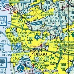
| Sectional chart |
|---|
|
CAUTION: Diagram may not be current
 Download PDF
of official airport diagram from the FAA
| Airport distance calculator |
|---|
|
|
| Sunrise and sunset |
|---|
|
Times for 02-May-2026
| | Local
(UTC-7) | | Zulu
(UTC) |
|---|
| Morning civil twilight | | 05:35 | | 12:35 |
| Sunrise | | 06:01 | | 13:01 |
| Sunset | | 19:30 | | 02:30 |
| Evening civil twilight | | 19:56 | | 02:56 |
|
| Current date and time |
|---|
| Zulu (UTC) | 02-May-2026 22:17:33 |
|---|
| Local (UTC-7) | 02-May-2026 15:17:33 |
|---|
|
| METAR |
|---|
| KMYF | 022153Z AUTO 30009KT 10SM CLR 21/14 A2990 RMK AO2 SLP121 T02060139
|
KNKX
3nm N | 022155Z 27010KT 10SM CLR 20/14 A2990 RMK AO2 SLP119 T02000139 $
|
KSAN
5nm SW | 022151Z 29011KT 10SM BKN018 BKN250 20/14 A2992 RMK AO2 SLP130 T02000139 $
|
KNZY
8nm SW | 022152Z 29013KT 10SM BKN017 BKN250 20/14 A2990 RMK AO2 SLP124 T02000139
|
KSEE
9nm E | 022147Z 28010KT 10SM SKC 24/15 A2989
|
KNRS
15nm S | 022053Z AUTO 27015KT 10SM CLR 20/14 A2993 RMK AO2 SLP135 T02000144 55013 $
|
KSDM
16nm SE | 022153Z 28009KT 10SM FEW015 21/14 A2989 RMK AO2 SLP119 T02060139 $
|
KRNM
17nm NE | 022153Z 27013G17KT 10SM CLR 26/14 A2989 RMK AO2 SLP109 T02560144
|
MMTJ
19nm SE | 022140Z 27013KT 8SM SCT200 21/14 A2993 RMK 8/008 HZY SC-W
|
|
| TAF |
|---|
KNKX
3nm N | 021500Z 0215/0315 VRB04KT 9999 SKC QNH2997INS FM021800Z 29005KT 9999 SCT018 QNH2994INS FM031200Z VRB02KT 9999 BKN025 OVC250 QNH2990INS TX23/0221 TN13/0309Z
|
KSAN
5nm SW | 021737Z 0218/0324 VRB04KT P6SM BKN015 FM021900 30010KT P6SM SCT020 SCT250 FM030200 VRB04KT P6SM BKN018 FM031200 VRB03KT P6SM OVC025 FM031900 30010KT P6SM SCT020 SCT250
|
KNZY
8nm SW | 021500Z 0215/0315 VRB06KT 9999 OVC012 QNH2988INS BECMG 0219/0221 29010KT 9999 SCT010 SCT250 QNH2985INS FM030300 30005KT 8000 BR BKN016 QNH2986INS TX21/0222Z TN16/0313Z FS30175
|
MMTJ
19nm SE | 021946Z 0218/0318 27010KT P6SM SCT017 OVC200 TX20/0220Z TN14/0310Z FM030200 00000KT 6SM HZ BKN015 BKN200 BECMG 0303/0304 5SM HZ BKN012 TEMPO 0310/0314 4SM HZ BKN008 OVC012 FM031600 25005KT 5SM HZ BKN015 OVC020 BECMG 0317/0318 6SM HZ BKN020
|
|
| NOTAMs |
|---|
NOTAMs are issued by the DoD/FAA and will open in a separate window not controlled by AirNav.
|
|


