FAA INFORMATION EFFECTIVE 23 JANUARY 2025
Location
| FAA Identifier: | 1B1 |
| Lat/Long: | 42-17-28.7000N 073-42-37.2000W
42-17.478333N 073-42.620000W
42.2913056,-73.7103333
(estimated) |
| Elevation: | 198.1 ft. / 60.4 m (surveyed) |
| Variation: | 13W (1965) |
| From city: | 4 miles NE of HUDSON, NY |
| Time zone: | UTC -5 (UTC -4 during Daylight Saving Time) |
| Zip code: | 12075 |
Airport Operations
| Airport use: | Open to the public |
| Control tower: | no |
| ARTCC: | BOSTON CENTER |
| FSS: | BURLINGTON FLIGHT SERVICE STATION |
| NOTAMs facility: | BTV (NOTAM-D service available) |
| Attendance: | 0700-1800 |
| Wind indicator: | yes |
| Segmented circle: | yes |
| Lights: | ACTVT REIL RWY 03 & 21; MIRL RWY 03/21 - CTAF. |
| Beacon: | white-green (lighted land airport)
Operates sunset to sunrise. |
| International operations: | customs landing rights airport |
Airport Communications
| CTAF/UNICOM: | 123.05 |
| WX AWOS-3: | 133.525 (518-828-2577) |
| ALBANY APPROACH: | 132.825 |
| ALBANY DEPARTURE: | 132.825 |
Nearby radio navigation aids
| VOR radial/distance | | VOR name | | Freq | | Var |
|---|
| ALBr184/27.7 | | ALBANY VORTAC | | 115.30 | | 13W |
| PWLr003/31.7 | | PAWLING VOR/DME | | 114.30 | | 12W |
| CTRr283/33.8 | | CHESTER VOR/DME | | 115.10 | | 13W |
| IGNr020/37.9 | | KINGSTON VOR/DME | | 117.60 | | 12W |
| NDB name | | Hdg/Dist | | Freq | | Var | | ID |
|---|
| HUNTER | | 178/35.2 | | 356 | | 14W | | HEU | .... . ..- |
Airport Services
| Fuel available: | 100 100LL JET-A1+
100LL:100LL SELF-SVC AVBL 24 HRS. |
| Parking: | hangars and tiedowns |
| Airframe service: | MAJOR |
| Powerplant service: | MINOR |
| Bottled oxygen: | HIGH |
| Bulk oxygen: | HIGH |
Runway Information
Runway 3/21
| Dimensions: | 5350 x 100 ft. / 1631 x 30 m |
| Surface: | asphalt/grooved, in excellent condition |
| Weight bearing capacity: | | PCN 29 /F/C/X/T | | Single wheel: | 69.0 | | Double wheel: | 111.0 | | Double tandem: | 358.0 |
|
| Runway edge lights: | medium intensity |
| RUNWAY 3 | | RUNWAY 21 |
| Latitude: | 42-17.046325N | | 42-17.909072N |
| Longitude: | 073-42.738582W | | 073-42.500060W |
| Elevation: | 198.1 ft. | | 194.0 ft. |
| Traffic pattern: | left | | left |
| Runway heading: | 024 magnetic, 011 true | | 204 magnetic, 191 true |
| Displaced threshold: | no | | 160 ft. |
| Markings: | nonprecision, in good condition | | nonprecision, in good condition |
| Visual slope indicator: | 4-light PAPI on left (3.00 degrees glide path) | | 4-light PAPI on right (3.52 degrees glide path) |
| Runway end identifier lights: | yes | | yes |
| Touchdown point: | yes, no lights | | yes, no lights |
| Obstructions: | 55 ft. tree, 610 ft. from runway, 107 ft. left of centerline, 7:1 slope to clear | | 39 ft. tree, 412 ft. from runway, 238 ft. right of centerline, 5:1 slope to clear |
Airport Ownership and Management from official FAA records
| Ownership: | Publicly-owned |
| Owner: | COUNTY OF COLUMBIA
401 STATE STREET
HUDSON, NY 12534
Phone 518-828-7011 |
| Manager: | BRIAN MCDONALD
401 STATE STREET, 178 ROUTE 23B
HUDSON, NY 12534
Phone 518-828-0871 |
Additional Remarks
| - | FOR CD CTC ALBANY APCH AT 518-862-2299. |
| - | RWY 21 DSGND CALM WIND RWY. |
| - | WILDLIFE ON AND INVOF ARPT. |
Instrument Procedures
NOTE: All procedures below are presented as PDF files. If you need a reader for these files, you should download the free Adobe Reader.NOT FOR NAVIGATION. Please procure official charts for flight.
FAA instrument procedures published for use from 23 January 2025 at 0901Z to 20 February 2025 at 0900z.
IAPs - Instrument Approach Procedures |
|---|
| RNAV (GPS) RWY 03 | |
download (249KB) |
| RNAV (GPS) RWY 21 | |
download (284KB) |
| NOTE: Special Take-Off Minimums/Departure Procedures apply | |
download (275KB) |
Other nearby airports with instrument procedures:
KGBR - Walter J Koladza Airport (15 nm SE)
4B0 - South Albany Airport (17 nm N)
KPSF - Pittsfield Municipal Airport (20 nm NE)
20N - Kingston-Ulster Airport (22 nm SW)
KALB - Albany International Airport (28 nm N)
|
|

Road maps at:
MapQuest
Bing
Google
| Aerial photo |
|---|
WARNING: Photo may not be current or correct
 Photo by Cathy Vajtay
Photo taken 25-Aug-2013
looking southeast from 4500'.
Photo by Cathy Vajtay
Photo taken 25-Aug-2013
looking southeast from 4500'.
Do you have a better or more recent aerial photo of Columbia County Airport that you would like to share? If so, please send us your photo.
|
| Sectional chart |
|---|
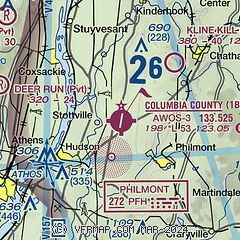
|
| Airport distance calculator |
|---|
|
|
| Sunrise and sunset |
|---|
|
Times for 16-Feb-2025
| | Local
(UTC-5) | | Zulu
(UTC) |
|---|
| Morning civil twilight | | 06:22 | | 11:22 |
| Sunrise | | 06:51 | | 11:51 |
| Sunset | | 17:27 | | 22:27 |
| Evening civil twilight | | 17:56 | | 22:56 |
|
| Current date and time |
|---|
| Zulu (UTC) | 16-Feb-2025 11:58:49 |
|---|
| Local (UTC-5) | 16-Feb-2025 06:58:49 |
|---|
|
| METAR |
|---|
KPSF
21nm NE | 161154Z AUTO 05009G18KT 3SM UP BR OVC015 M04/M06 A2969 RMK AO2 SLP070 P0006 60019 70057 I6008 T10391061 11039 21061 58053
|
KALB
28nm N | 161153Z 34004KT 2SM +PLSN BR BKN007 OVC013 M02/M04 A2970 RMK AO2 SFC VIS 3 P0000 T10221039
|
KAQW
34nm NE | 161152Z AUTO 11020G28KT 3SM UP FEW038 OVC055 M03/M06 A2973 RMK AO2 PK WND 12034/1134 UPE04B25 SLP076 P0006 60010 70029 I6004 T10281061 11028 21050 58058
|
KSCH
35nm N | 160158Z 06004KT 1SM SN BKN012 OVC018 M06/M07 A3009 RMK LAST
|
KPOU
40nm S | 161153Z AUTO 00000KT 3SM FZRA BR BKN009 OVC012 00/00 A2968 RMK AO2 SLP050 P0009 60026 70055 I1005 I6019 T00000000 10000 21017 56048
|
KDDH
41nm NE | 161154Z AUTO 09011G22KT 3SM FZRA SCT036 OVC050 M02/M06 A2966 RMK AO2 PRESFR SLP054 P0007 60012 70025 I1003 I6005 T10221061 11017 21039 56048
|
|
| TAF |
|---|
KPSF
21nm NE | 160738Z 1608/1706 07009KT 2SM -FZRAPL BR SCT009 OVC015 TEMPO 1608/1610 3SM -FZRA BR OVC009 FM161000 09010KT 2SM -FZRA BR OVC006 WS020/12040KT FM161500 10011G18KT 2SM -FZRA BR OVC008 FM170000 28011G20KT P6SM VCSH SCT012 OVC025 FM170300 28020G35KT P6SM OVC035
|
|
| NOTAMs |
|---|
NOTAMs are issued by the DoD/FAA and will open in a separate window not controlled by AirNav.
|
|


