FAA INFORMATION EFFECTIVE 22 JANUARY 2026
Location
| FAA Identifier: | 5D6 |
| Lat/Long: | 40-38-53.0900N 081-04-10.3000W
40-38.884833N 081-04.171667W
40.6480806,-81.0695278
(estimated) |
| Elevation: | 1270 ft. / 387 m (estimated) |
| Variation: | 07W (1985) |
| From city: | 5 miles N of CARROLLTON, OH |
| Time zone: | UTC -5 (UTC -4 during Daylight Saving Time) |
| Zip code: | 44615 |
Airport Operations
| Airport use: | Open to the public |
| Activation date: | 05/1959 |
| Control tower: | no |
| ARTCC: | CLEVELAND CENTER |
| FSS: | CLEVELAND FLIGHT SERVICE STATION |
| NOTAMs facility: | CLE (NOTAM-D service available) |
| Attendance: | IREG |
| Wind indicator: | yes |
| Segmented circle: | no |
Airport Communications
| CTAF: | 122.9 |
| WX ASOS at PHD (19 nm SW): | 121.425 (330-339-1125) |
Nearby radio navigation aids
| VOR radial/distance | | VOR name | | Freq | | Var |
|---|
| BSVr113/17.4 | | BRIGGS VOR/DME | | 114.05 | | 04W |
| ACOr172/28.2 | | AKRON VOR/DME | | 114.40 | | 04W |
| HLGr323/32.6 | | WHEELING VOR/DME | | 114.25 | | 07W |
| AIRr350/39.6 | | BELLAIRE VOR/DME | | 117.10 | | 07W |
| NDB name | | Hdg/Dist | | Freq | | Var | | ID |
|---|
| CADIZ | | 001/24.8 | | 239 | | 07W | | CFX | -.-. ..-. -..- |
| CASTLE | | 242/37.2 | | 272 | | 09W | | UCP | ..- -.-. .--. |
Airport Services
| Parking: | tiedowns |
| Airframe service: | MINOR |
| Powerplant service: | MINOR |
| Bottled oxygen: | NONE |
| Bulk oxygen: | NONE |
Runway Information
Runway 10/28
| Dimensions: | 2570 x 75 ft. / 783 x 23 m |
| Surface: | turf, in good condition
UPSLP FM EAST TO WEST; SOFT WHEN WET. |
| Runway edge markings: | RWY MKD WITH WHITE PANELS FLAT TO THE GND & ORANGE & YELLOW VER SIGNS; THR MKD WITH YELLOW TIRES. |
| Operational restrictions: | NO LINE OF SIGHT BTN RWY ENDS. |
| RUNWAY 10 | | RUNWAY 28 |
| Latitude: | 40-38.890500N | | 40-38.879167N |
| Longitude: | 081-04.449500W | | 081-03.894000W |
| Elevation: | 1269.0 ft. | | 1220.0 ft. |
| Traffic pattern: | left | | left |
| Runway heading: | 099 magnetic, 092 true | | 279 magnetic, 272 true |
| Touchdown point: | yes, no lights | | yes, no lights |
| Obstructions: | 60 ft. trees, 417 ft. from runway, 6:1 slope to clear | | 65 ft. trees, 334 ft. from runway, 91 ft. right of centerline, 5:1 slope to clear
ALSO +25 FT BLDG, 126 FT DIST, 95 FT R, 5:1. |
Airport Ownership and Management from official FAA records
| Ownership: | Privately-owned |
| Owner: | DONNA M PARSONS
5043 KENSINGTON RD NE
CARROLLTON, OH 44615-9744
Phone 330-627-5794 |
| Manager: | LEE PARSONS
5043 KENSINGTON RD NE
CARROLLTON, OH 44615-9744
Phone 330-627-5794 |
Additional Remarks
| - | DEER, BIRDS, & WILDLIFE ON & INVOF ARPT. |
| - | FOR CD CTC CLEVELAND APCH AT 216-352-2323, WHEN APCH CLSD CTC CLEVELAND ARTCC AT 440-774-0223/0490. |
Instrument Procedures
There are no published instrument procedures at 5D6.
Some nearby airports with instrument procedures:
KTSO - Carroll County/Tolson Airport (5 nm S)
3G6 - Tri-City Airport (16 nm N)
KPHD - Harry Clever Field Airport (19 nm SW)
02G - Columbiana County Airport (20 nm E)
38D - Salem Airpark (20 nm NE)
|
|

Road maps at:
MapQuest
Bing
Google
| Aerial photo |
|---|
WARNING: Photo may not be current or correct
 Photo by Rick Hunt
Photo taken 19-Oct-2014
looking east.
Photo by Rick Hunt
Photo taken 19-Oct-2014
looking east.
Do you have a better or more recent aerial photo of Parsons Airport that you would like to share? If so, please send us your photo.
|
| Sectional chart |
|---|
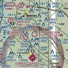
|
| Airport distance calculator |
|---|
|
|
| Sunrise and sunset |
|---|
|
Times for 29-Jan-2026
| | Local
(UTC-5) | | Zulu
(UTC) |
|---|
| Morning civil twilight | | 07:09 | | 12:09 |
| Sunrise | | 07:38 | | 12:38 |
| Sunset | | 17:37 | | 22:37 |
| Evening civil twilight | | 18:06 | | 23:06 |
|
| Current date and time |
|---|
| Zulu (UTC) | 29-Jan-2026 07:26:34 |
|---|
| Local (UTC-5) | 29-Jan-2026 02:26:34 |
|---|
|
| METAR |
|---|
KPHD
19nm SW | 290653Z AUTO 00000KT 10SM OVC044 M14/M19 A3017 RMK AO2 SLP238 T11441189
|
KCAK
24nm NW | 290651Z 24008KT 4SM -SN FEW029 OVC040 M15/M18 A3011 RMK AO2 SLP223 P0000 T11501178 $
|
KAKR
29nm NW | 290654Z AUTO 22007KT 8SM OVC041 M14/M18 A3011 RMK AO2 SLP218 T11391178
|
KBVI
31nm E | 290715Z AUTO 26005KT 10SM OVC040 M14/M17 A3011 RMK AO2 T11361175
|
KHLG
35nm SE | 290653Z AUTO 24008KT 10SM OVC034 M14/M19 A3014 RMK AO2 SLP235 T11441189
|
KPOV
35nm N | 290715Z AUTO 25006KT 10SM SCT028 OVC038 M14/M17 A3010 RMK AO2 T11401168
|
KUCP
37nm NE | 290656Z AUTO 22005KT 8SM -SN FEW013 BKN042 OVC060 M17/M20 A3012 RMK AO2 SNB46 SLP240 P0000 T11721200
|
KPIT
38nm E | 290651Z 25006KT 10SM FEW026 SCT040 BKN080 M16/M19 A3012 RMK AO2 SLP234 T11561189
|
|
| TAF |
|---|
KCAK
24nm NW | 290544Z 2906/3006 25007KT 6SM -SHSN SCT025 BKN040 FM291000 25006KT P6SM BKN040 FM291500 28006KT P6SM BKN030 FM300000 VRB03KT P6SM SCT030
|
|
| NOTAMs |
|---|
NOTAMs are issued by the DoD/FAA and will open in a separate window not controlled by AirNav.
|
|


