FAA INFORMATION EFFECTIVE 25 DECEMBER 2025
Location
| FAA Identifier: | 8G8 |
| Lat/Long: | 40-52-57.6994N 080-52-51.6816W
40-52.961657N 080-52.861360W
40.8826943,-80.8810227
(estimated) |
| Elevation: | 1327 ft. / 404 m (estimated) |
| Variation: | 07W (1985) |
| From city: | 2 miles SW of SALEM, OH |
| Time zone: | UTC -5 (UTC -4 during Daylight Saving Time) |
| Zip code: | 44460 |
Airport Operations
| Airport use: | Open to the public |
| Control tower: | no |
| ARTCC: | CLEVELAND CENTER |
| FSS: | CLEVELAND FLIGHT SERVICE STATION |
| NOTAMs facility: | CLE (NOTAM-D service available) |
| Attendance: | UNATNDD |
| Wind indicator: | yes |
| Segmented circle: | no |
Airport Communications
Nearby radio navigation aids
| VOR radial/distance | | VOR name | | Freq | | Var |
|---|
| ACOr137/19.8 | | AKRON VOR/DME | | 114.40 | | 04W |
| BSVr075/26.4 | | BRIGGS VOR/DME | | 114.05 | | 04W |
| EWCr285/30.6 | | ELLWOOD CITY VOR/DME | | 115.80 | | 08W |
| HLGr346/40.0 | | WHEELING VOR/DME | | 114.25 | | 07W |
| NDB name | | Hdg/Dist | | Freq | | Var | | ID |
|---|
| CASTLE | | 257/22.7 | | 272 | | 09W | | UCP | ..- -.-. .--. |
| CADIZ | | 016/39.2 | | 239 | | 07W | | CFX | -.-. ..-. -..- |
Airport Services
| Airframe service: | NONE |
| Powerplant service: | NONE |
| Bottled oxygen: | NONE |
| Bulk oxygen: | NONE |
Runway Information
Runway 9/27
| Dimensions: | 1821 x 100 ft. / 555 x 30 m |
| Surface: | turf, in good condition |
| Runway edge markings: | THR & EDGES MKD WITH ORANGE TFC CONES. |
| RUNWAY 9 | | RUNWAY 27 |
| Latitude: | 40-52.967693N | | 40-52.955613N |
| Longitude: | 080-53.058738W | | 080-52.663980W |
| Elevation: | 1317.7 ft. | | 1326.9 ft. |
| Traffic pattern: | left | | right |
| Runway heading: | 099 magnetic, 092 true | | 279 magnetic, 272 true |
| Runway end identifier lights: | no | | no |
| Touchdown point: | yes, no lights | | yes, no lights |
| Obstructions: | 33 ft. tree, 406 ft. from runway, 54 ft. left of centerline, 12:1 slope to clear | | 90 ft. trees, 101 ft. from runway, 110 ft. left of centerline
ALSO 16 FT ROAD, 0 FT DIST, 250 FT L/R. |
Airport Ownership and Management from official FAA records
| Ownership: | Privately-owned |
| Owner: | DAVID & HARRY KOONS
1760 STATE ROUTE 9
SALEM, OH 44460-9583
Phone 330-337-7303
330-337-1780. |
| Manager: | DAVID & HARRY KOONS
1760 STATE ROUTE 9
SALEM, OH 44460-9583
Phone 330-337-7303
CELL 234-564-5827. |
Additional Remarks
| - | FOR CD CTC CLEVELAND APCH AT 216-352-2323, WHEN APCH CLSD CTC CLEVELAND ARTCC AT 440-774-0223/0490. |
| - | DEER, BIRDS, & WILDLIFE ON & INVOF ARPT. |
Instrument Procedures
There are no published instrument procedures at 8G8.
Some nearby airports with instrument procedures:
38D - Salem Airpark (4 nm N)
3G6 - Tri-City Airport (6 nm W)
4G4 - Youngstown Elser Metro Airport (10 nm NE)
02G - Columbiana County Airport (17 nm SE)
KTSO - Carroll County/Tolson Airport (21 nm SW)
|
|

Road maps at:
MapQuest
Bing
Google
| Aerial photo |
|---|
WARNING: Photo may not be current or correct
 Photo by Rick Hunt
Photo taken 22-Mar-2015
looking south.
Photo by Rick Hunt
Photo taken 22-Mar-2015
looking south.
Do you have a better or more recent aerial photo of Koons Airport that you would like to share? If so, please send us your photo.
|
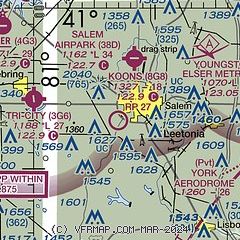
| Sectional chart |
|---|
|
| Airport distance calculator |
|---|
|
|
| Sunrise and sunset |
|---|
|
Times for 16-Jan-2026
| | Local
(UTC-5) | | Zulu
(UTC) |
|---|
| Morning civil twilight | | 07:16 | | 12:16 |
| Sunrise | | 07:47 | | 12:47 |
| Sunset | | 17:20 | | 22:20 |
| Evening civil twilight | | 17:50 | | 22:50 |
|
| Current date and time |
|---|
| Zulu (UTC) | 17-Jan-2026 00:10:03 |
|---|
| Local (UTC-5) | 16-Jan-2026 19:10:03 |
|---|
|
| METAR |
|---|
KUCP
23nm E | 162356Z AUTO VRB06KT 10SM OVC039 M02/M09 A2979 RMK AO2 SLP119 60000 T10221094 11022 21039 53013
|
KBVI
23nm E | 162355Z AUTO 22008KT 10SM OVC038 00/M10 A2979 RMK AO2 T00001096
|
KYNG
24nm NE | 162351Z 20008KT 10SM -SN BKN041 OVC075 M03/M09 A2976 RMK AO2 SNB50 SLP094 4/002 P0000 60000 T10281094 11028 21056 53015 $
|
KPOV
26nm NW | 162355Z AUTO 20006KT 10SM OVC030 M02/M09 A2975 RMK AO2 T10221090
|
KCAK
26nm W | 162351Z 21017KT 10SM OVC030 M02/M09 A2975 RMK AO2 SLP092 4/001 60000 T10221089 11022 21050 53018 $
|
KAKR
28nm W | 162354Z AUTO 20012KT 10SM OVC030 M02/M09 A2974 RMK AO2 SLP084 T10221089 11022 21050 53020
|
KPJC
33nm E | 162355Z AUTO 15003KT 10SM OVC044 M01/M10 A2981 RMK AO2
|
KPHD
35nm SW | 162353Z AUTO 20008KT 150V230 10SM FEW037 SCT048 OVC080 M01/M09 A2979 RMK AO2 SLP100 T10061094 11006 21039 53020
|
KPIT
36nm SE | 162351Z 19004KT 10SM FEW033 OVC045 M02/M11 A2979 RMK AO2 SLP113 60000 T10171111 11017 21039 53012
|
KBTP
43nm E | 162356Z AUTO 19011G16KT 10SM BKN045 OVC050 M02/M09 A2980 RMK AO2 SLP116 60000 T10221094 11022 21044 53013 FZRANO $
|
|
| TAF |
|---|
KBVI
23nm E | 162031Z 1621/1718 19012KT P6SM OVC050 FM162300 21008KT 5SM -SN OVC045 WS020/21040KT PROB30 1700/1703 2SM -SN OVC030 FM170300 21007KT 2SM -SN OVC010 FM170700 21006KT 2SM -SN OVC007 FM171600 23008G16KT 3SM -SN OVC015
|
KYNG
24nm NE | 161734Z 1618/1718 18012G20KT P6SM OVC035 FM162200 19012G22KT 6SM -SHSN OVC035 TEMPO 1623/1701 3SM -SHSN OVC025 FM170100 21008KT P6SM VCSH OVC022 FM170500 21008KT 2SM -SN BKN012 FM171000 21008KT P6SM VCSH OVC008 FM171500 23010KT P6SM OVC012
|
KCAK
26nm W | 162325Z 1623/1724 20010G18KT P6SM VCSH OVC035 FM170300 20010KT P6SM OVC025 FM170500 21008KT 1 1/2SM -SN OVC008 FM170900 21008KT P6SM -SHSN OVC005 FM171500 22010KT 4SM -SHSN OVC015 FM171700 24012G20KT 4SM -SHSN OVC015
|
|
| NOTAMs |
|---|
NOTAMs are issued by the DoD/FAA and will open in a separate window not controlled by AirNav.
|
|


